Contributory members are able to log private notes and comments about each site
Sites Anne T has logged on trip number: 124 (View all trips)
View this log as a table or view the most recent logs from everyone
Wamphray Place
Trip No.124 Entry No.5 Date Added: 11th Apr 2019
Site Type: Misc. Earthwork
Country: Scotland (Dumfries and Galloway)
Visited: Saw from a distance on 4th Apr 2019. My rating: Condition 1 Ambience 3 Access 4

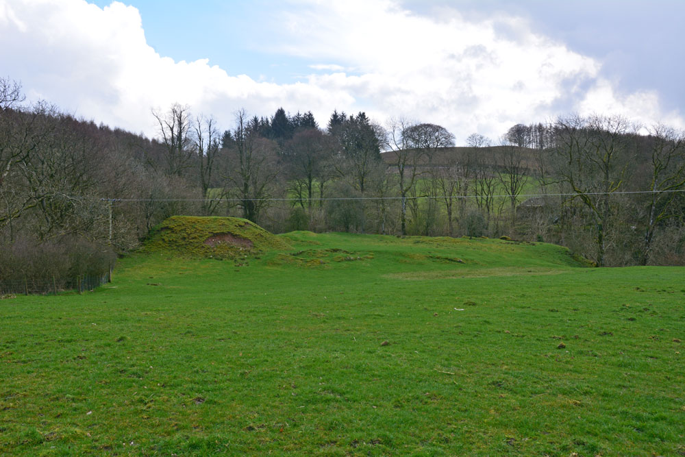
Wamphray Place submitted by Anne T on 11th Apr 2019. Having seen the cross slab at Wamphray Church, we stopped by the side of the road to photograph this picturesque motte and bailey castle, high above Wamphray Water, but as we had a rendezvous, didn't stop to explore further. This site was known to be occupied in the 12th century and was still in use until the mid 18th century. Possibly, the motte is built upon a more ancient site.
(View photo, vote or add a comment)
Log Text: Wamphray Place Motte & Bailey: Continuing down the hill (north west) from Wamphray Church, past the mill and over the narrow bridge, as we climbed the hill at the other side of the river, we spotted this small, compact motte and bailey and stopped to take a few quick photos. Wish we’d had more time to explore and photograph this site from the river, but we wanted to try and find the cairn cemetery at Pumplaburn before heading off to meet our daughter at Annandale Water services.
St Cuthbert's Church (Wamphray)
Trip No.124 Entry No.4 Date Added: 5th Apr 2019
Site Type: Ancient Cross
Country: Scotland (Dumfries and Galloway)
Visited: Yes on 4th Apr 2019. My rating: Condition 3 Ambience 3 Access 4

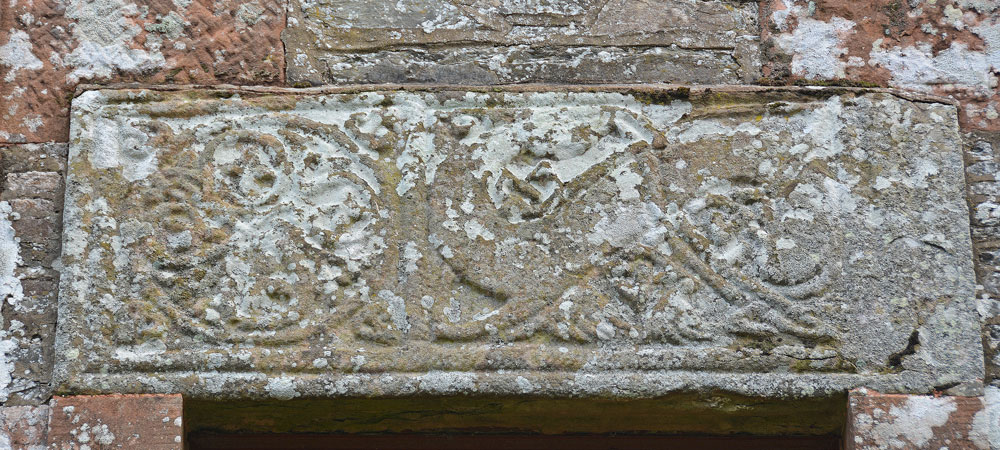
St Cuthbert's Church (Wamphray) submitted by Anne T on 5th Apr 2019. The Anglo Scandinavian cross slab above the west door of Wamphray Parish church, which is dedicated to St Cuthbert. Canmore tells us: "The front of the slab is divided into two panels by a cable moulding. The left panel is filled with a symmetrical knot formed by the interlacing of four plant scrolls, and that on the right by a backward-biting quadruped".
(View photo, vote or add a comment)
Log Text: Anglo Scandinavian Cross Slab, St Cuthbert's Church, Wamphray: This seemed far too modern a church to incorporate any old stones, but I was to be surprised. The churchyard was quite spectacular, with a large walled mausoleum and two very large monuments, one being a replica of a churchyard cross.
We found the stone over the west door of the church. It was an interesting exercise to photograph this, as the ground sloped down very steeply to the river. The stone was carved on its wide face, and also some interlacing on its underside, next to the door.
Sadly, the church was very firmly padlocked and doors locked, so we were unable to get to see the reverse side of the slab. There was a modern, recreation of a churchyard cross at the south side of the church, near the gate into the churchyard.
Skip Knowe
Trip No.124 Entry No.1 Date Added: 4th Apr 2019
Site Type: Standing Stone (Menhir)
Country: Scotland (Dumfries and Galloway)
Visited: Yes on 4th Apr 2019. My rating: Condition 3 Ambience 4 Access 4

Skip Knowe submitted by Apocryphus on 20th Jan 2019. On a minor road south of Moffat.
Located under trees and over a fence but close to the road. A substantial stone shown on OS maps
(View photo, vote or add a comment)
Log Text: Skip Knowe Standing Stone: Our first stop of the day, which nearly wasn’t, as we got caught in a SSE convoy putting up new poles and wires. We stopped by what looked like a community hall and I asked permission to park there for 10 minutes whilst we walked back 100m to look at the standing stone. We were told that was OK, but we needed to move within half an hour otherwise they would be stringing a cable over our car. No sooner had we spoken to one helpful worker, than another appeared and we went through the same exercise!
We were quickly able to walk back to the stone, hop over the fence into the field, take a few photos and back to the car just as a new pole was being craned into position in front of the neighbouring house.
This is a huge standing stone, just opposite Skip Cottage, with the River Annan just to the west. There were no discernible features on the stone that we could see, and we had a good look around. There were a couple of large boulders in the bank just to the west of the stone, but these looked like just part of the bank, but the Canmore entry from 1906 mentions a possible second stone.
Pumplaburn
Trip No.124 Entry No.6 Date Added: 11th Apr 2019
Site Type: Cairn
Country: Scotland (Dumfries and Galloway)
Visited: Saw from a distance on 4th Apr 2019. My rating: Condition 1 Ambience 2 Access 4

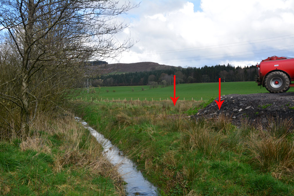
Pumplaburn submitted by Anne T on 11th Apr 2019. The two arrows show approximately where the two cairns should be - one buried (almost buried?) by the new hardstanding area; the other further back in the field. Photograph taken from the corner of the field at NY 11832 96456.
(View photo, vote or add a comment)
Log Text: Pumplaburn Cairns: Making our way back towards Annandale Water, we went under the smallest railway bridge we’d ever travelled under – 7ft tall and 7ft wide! We didn’t find these cairns, despite wandering up and down the road. Looks like they may have been buried by the large hardstanding for tractors next to Pumplaburn Steading. From plotting the ngrs on UK Grid Reference Finder, the cairn at NY 1191 9650 may still be there, but we only saw it from a distance.
Poldean menhir
Trip No.124 Entry No.3 Date Added: 5th Apr 2019
Site Type: Standing Stone (Menhir)
Country: Scotland (Dumfries and Galloway)
Visited: Yes on 4th Apr 2019. My rating: Condition 3 Ambience 3 Access 4

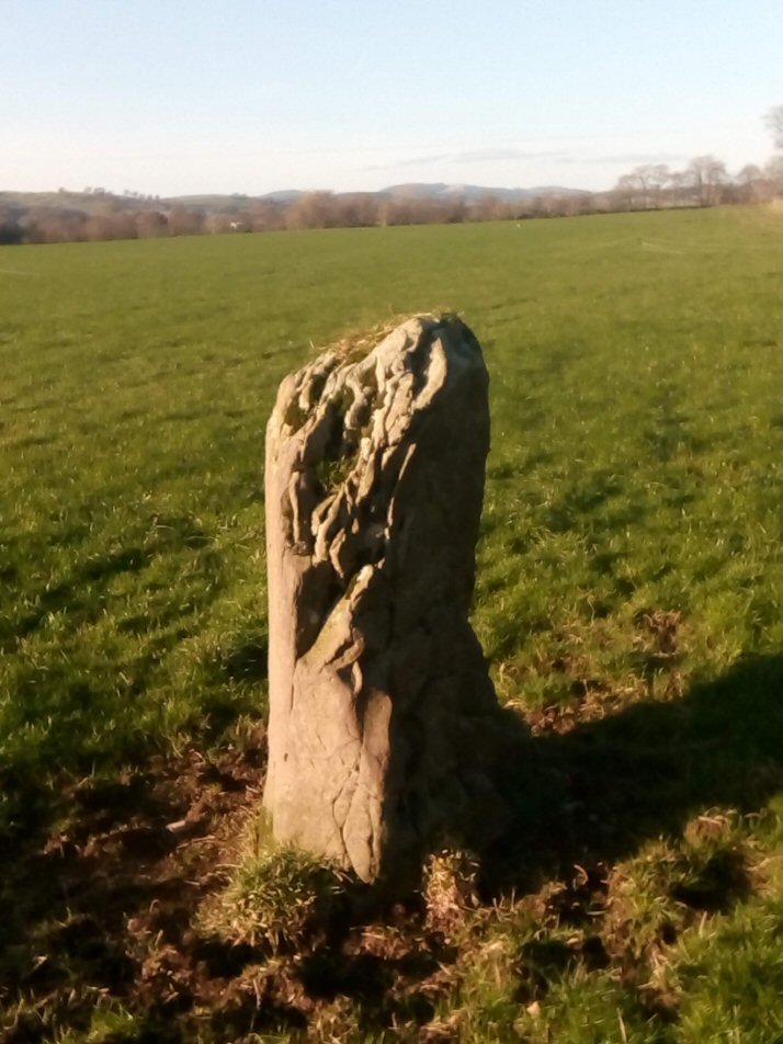
Poldean submitted by Apocryphus on 20th Jan 2019. A smaller stone located opposite Poldean Farm on a minor road south of Moffat
(View photo, vote or add a comment)
Log Text: Poldean Standing Stone: The third stop of the day with this stone easily visible just to the west of the road, towards the eastern edge of a large field of pasture.
We let ourselves in through the gate NY 10424 99981, walking over a small stream, again with the River Annan to its west and the busy A754(M) in the distance.
The eastern side of the stone is very craggy, as if bedding planes have been worn/broken away. There appears to have been a cup low down on its western side, but this could be a solution hole, if the stone had been lying flat for some considerable time in the past.
Chapman's Stone
Trip No.124 Entry No.2 Date Added: 5th Apr 2019
Site Type: Standing Stone (Menhir)
Country: Scotland (Dumfries and Galloway)
Visited: Yes on 4th Apr 2019. My rating: Condition 3 Ambience 3 Access 5

Chapman's Stone submitted by Anne T on 5th Apr 2019. Standing just to the west of stone, looking eastwards. The end of the stone nearest us is the tapered end, which would have been the top of the stone when it stood upright.
(View photo, vote or add a comment)
Log Text: Chapman's Stone: Our second stop of the day, and easy to stop alongside the road where it widens slightly, at NY 10746 99049 and walked back the short way to the stone. The stone has a fence built right over the middle of it (it looks like it could be used as a stile). It’s eastern side looks as if it has been knocked and broken by farm equipment. Looking at where the stone is placed in the landscape, it is along an old drover’s road, with the River Annan to its western side; to the NE, there are two flat topped hills in the distance.
