


<< Our Photo Pages >> Pumplaburn - Cairn in Scotland in Dumfries and Galloway
Submitted by Anne T on Thursday, 11 April 2019 Page Views: 729
Neolithic and Bronze AgeSite Name: PumplaburnCountry: Scotland County: Dumfries and Galloway Type: Cairn
Nearest Town: Moffat Nearest Village: Johnstonebridge
Map Ref: NY11869644
Latitude: 55.254228N Longitude: 3.388197W
Condition:
| 5 | Perfect |
| 4 | Almost Perfect |
| 3 | Reasonable but with some damage |
| 2 | Ruined but still recognisable as an ancient site |
| 1 | Pretty much destroyed, possibly visible as crop marks |
| 0 | No data. |
| -1 | Completely destroyed |
| 5 | Superb |
| 4 | Good |
| 3 | Ordinary |
| 2 | Not Good |
| 1 | Awful |
| 0 | No data. |
| 5 | Can be driven to, probably with disabled access |
| 4 | Short walk on a footpath |
| 3 | Requiring a bit more of a walk |
| 2 | A long walk |
| 1 | In the middle of nowhere, a nightmare to find |
| 0 | No data. |
| 5 | co-ordinates taken by GPS or official recorded co-ordinates |
| 4 | co-ordinates scaled from a detailed map |
| 3 | co-ordinates scaled from a bad map |
| 2 | co-ordinates of the nearest village |
| 1 | co-ordinates of the nearest town |
| 0 | no data |
Internal Links:
External Links:
I have visited· I would like to visit
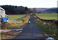
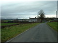
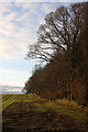
Anne T saw from a distance on 4th Apr 2019 - their rating: Cond: 1 Amb: 2 Access: 4 Pumplaburn Cairns: Making our way back towards Annandale Water, we went under the smallest railway bridge we’d ever travelled under – 7ft tall and 7ft wide! We didn’t find these cairns, despite wandering up and down the road. Looks like they may have been buried by the large hardstanding for tractors next to Pumplaburn Steading. From plotting the ngrs on UK Grid Reference Finder, the cairn at NY 1191 9650 may still be there, but we only saw it from a distance.
")
These cairns, recorded as Canmore ID 89727 are located at NY 1186 9644 and NY 1191 9650 near Pumplaburn Steading, just off the eastern side of the public road.
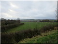
Whilst the site appears to be pasture on aerial photographs, there is a recently constructed large hardstanding area for heavy farm machinery in most of the field in which these cairns are located. The cairn at NY 1186 9644 appears to be obscured by the 1m high gravelled area; the second cairn at NY 1191 9650 may still be there. We looked very closely from the road but were unable to see any mounds; with the farm machinery in use, we didn't venture closer.
Canmore says: "A cairn (at NY 1186 9644) measuring about 20m in diameter and 0.5m in height is situated in pasture immediately E of the public road a short distance N of Pumplaburn steading … A second cairn (at NY 1191 9650 measuring 14m in diameter and 0.3m in height) is situated 55m to the NE".
You may be viewing yesterday's version of this page. To see the most up to date information please register for a free account.
Do not use the above information on other web sites or publications without permission of the contributor.
Nearby Images from Geograph Britain and Ireland:
©2009(licence)
©2006(licence)
©2017(licence)
©2009(licence)
©2017(licence)
The above images may not be of the site on this page, they are loaded from Geograph.
Please Submit an Image of this site or go out and take one for us!
Click here to see more info for this site
Nearby sites
Key: Red: member's photo, Blue: 3rd party photo, Yellow: other image, Green: no photo - please go there and take one, Grey: site destroyed
Download sites to:
KML (Google Earth)
GPX (GPS waypoints)
CSV (Garmin/Navman)
CSV (Excel)
To unlock full downloads you need to sign up as a Contributory Member. Otherwise downloads are limited to 50 sites.
Turn off the page maps and other distractions
Nearby sites listing. In the following links * = Image available
958m E 86° Wamphray Place* Misc. Earthwork (NY12829648)
1.2km E 88° St Cuthbert's Church (Wamphray)* Ancient Cross (NY1307096462)
2.1km SSW 198° Skip Knowe* Standing Stone (Menhir) (NY1118094430)
2.2km ESE 102° Kirkhill* Stone Circle (NY1397895929)
2.8km NNW 336° Chapman's Stone* Standing Stone (Menhir) (NY1078398986)
3.9km NNW 336° Poldean menhir* Standing Stone (Menhir) (NT1037900011)
6.2km WSW 243° Crunzierton Wood Scooped Settlement* Ancient Village or Settlement (NY0625093750)
7.5km SSW 197° Lochbrow Cursus* Cursus (NY0951489350)
7.7km SSW 197° Lochbrow Prehistoric Landscape* Ancient Village or Settlement (NY0942389153)
8.0km WNW 286° Stiddrig* Cairn (NY04139877)
8.2km NNW 334° Dyke Row* Stone Row / Alignment (NT0837503820)
8.5km SSW 198° Archwood Hill* Hillfort (NY0911488380)
9.9km WNW 287° Lonnachie Rig Cairn (NY024995)
11.1km NNW 345° Moffat Well* Holy Well or Sacred Spring (NT0924007200)
12.8km ESE 105° Castle O'er Fort* Hillfort (NY2419092850)
13.0km ESE 102° Over Rig* Misc. Earthwork (NY2455693475)
13.0km E 93° Bessie's Hill Fort* Hillfort (NY2490095540)
13.0km E 93° Bessie's Hill Settlement Ancient Village or Settlement (NY249955)
13.1km SE 126° Kirkslight Rig Stone Circle (NY223885)
13.2km ENE 73° Naga Stupa(cairn)* Modern Stone Circle etc (NT246001)
13.4km SE 127° Whitcastles* Stone Circle (NY22408806)
13.5km E 90° Girdle Stanes* Stone Circle (NY2535196153)
13.5km ESE 107° The Knowe* Ancient Village or Settlement (NY24799226)
13.8km E 88° Loupin' Stanes NW* Stone Circle (NY25709663)
13.8km E 88° Loupin' Stanes SE* Stone Row / Alignment (NY25729660)
View more nearby sites and additional images


 We would like to know more about this location. Please feel free to add a brief description and any relevant information in your own language.
 Wir möchten mehr über diese Stätte erfahren. Bitte zögern Sie nicht, eine kurze Beschreibung und relevante Informationen in Deutsch hinzuzufügen.
 Nous aimerions en savoir encore un peu sur les lieux. S'il vous plaît n'hesitez pas à ajouter une courte description et tous les renseignements pertinents dans votre propre langue.
 Quisieramos informarnos un poco más de las lugares. No dude en añadir una breve descripción y otros datos relevantes en su propio idioma.