Contributory members are able to log private notes and comments about each site
Sites Anne T has logged. View this log as a table or view the most recent logs from everyone
Warrior's Rest
Date Added: 29th Jun 2015
Site Type: Standing Stone (Menhir)
Country: Scotland (Scottish Borders)
Visited: Yes on 27th Jun 2015. My rating: Condition 3 Ambience 4 Access 4
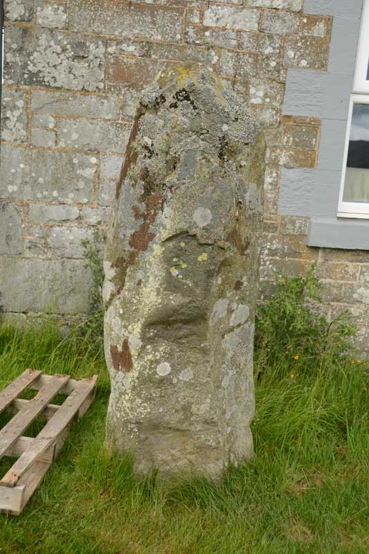
Warrior's Rest submitted by Anne T on 29th Jun 2015. A close up of the Warrior's Rest east face, but no cup marks that I can see. I wonder if the report of these cups got muddled with the Glebe Stone, just down the road, as I could see two cups on its eastern face.
(View photo, vote or add a comment)
Log Text: Warrior Stone, Yarrow, Scottish Borders: The Canmore Site (no. 53054) notes say that this stone is “at the south east corner of the cottage known as Warrior’s Rest, 300 yards west of Yarrow Church, there is a standing stone measuring 5ft 3ins in height, 5ft 9ins round the base and 4ft around the shoulder. The top is pointed.”
As the crow flies, it is just over 700 metres east of the Yarrow Stone, back towards Yarrow village. We spotted the small white signpost to Warrior’s Rest cottage at the left hand side of the road and stopped at the entrance. We couldn’t see any standing stone in the vicinity at all, even climbing the steps to the nearby war memorial just to the west of the cottage to see if we could spot anything. In the end, I walked up the track towards the cottage and spotted what appeared to be the top of a small standing stone peeking out above one of the two cars parked on the driveway.
Having come all this way, I was disappointed not to be able to see the stone, so decided to walk up and knock on the door. The curtains were drawn and the door to the garage was open, but despite knocking and calling out, I got no response, so decided to be cheeky and take a couple of photographs (and if anyone came, I’d explain). The stone literally stand a couple of feet away from the front bedroom window – whether its still in its original place and the cottage was built next to it, or the stone has been relocated next to the cottage was difficult to tell.
The Canmore notes also say there are two, previously unreported, cup marks on the eastern side of the stone, although I did quickly examine the stone for any cup marks, but didn’t see any. Usually my camera can pick up on things the eye finds difficult to differentiate at the time, but examining the photos this morning, I couldn’t see anything. I wonder now, at the time of writing, if this has been confused with the Glebe Stone, as I did see two cup marks on the eastern face of this stone.
The Yarrow Stone
Date Added: 29th Jun 2015
Site Type: Standing Stone (Menhir)
Country: Scotland (Scottish Borders)
Visited: Yes on 27th Jun 2015. My rating: Condition 3 Ambience 4 Access 4
The Yarrow Stone submitted by mafenty on 28th Mar 2007. The Yarrow Stone
(View photo, vote or add a comment)
Log Text: The Yarrow Stone, Yarrow, Scottish Borders: From Selkirk, we took the A708 towards St Mary’s Loch and Moffat. There was a diversion coming out of Selkirk, due to roadworks, so we had to double back to get onto the A708. Passing through the hamlet of Yarrowford, the road runs by Yarrow Water to the left hand side – a very pleasant, fertile valley. Reaching Yarrow, the kirk was signposted to the right hand side of the road, and a small grass-crete area in the centre of a triangle of roads made it possible to stop and get our bearings. Continuing westwards along the A708, we kept our eyes peeled for standing stones which, according to the Canmore notes, were visible from the road, but didn’t see anything. We reached the hamlet of Yarrow Feus before turning back and retracing our steps towards Yarrow.
We found the signpost for Whitefield (a farm) easily enough on the left hand side of the road, and there was a small layby big enough for two cars to park by the side of the A708. From here, a track led up to a gate into a field, where the Yarrow Stone was visible surrounded by a wooden fence to protect it from stock (there were none in the field at the time of our visit). The grid reference was spot on (thank you!) and it was an easy, short walk up the stony track.
There is a small plaque which reads: “The Yarrow Stone. This inscribed stone records the grave of two Christian British princes who lived during the 5th or 6th century AD. It was uncovered around 1803, when up to twenty large stone cairns were removed from a former moor, known as Annan Street, to create arable fields. The inscription is in Latin and can be read as: (+) HIC MEMORIA PE(RP)ETV(A) {I}N LOCO INSIGNISIMI PRINCI PES NVDI DVMNOGENI HIC IACENT IN TVMVLO DVO FILI LIBARALI{S} which translated means “this is the everlasting memorial. In this place lie the most famous princes Nudoss and Dumnogenos. In this tomb lie the two sons of Liberalis.” After the end of Roman Britain, in the 5th century AD, much of the Southern Uplands became part of the British Kingdom of Strathclyde. St. Ninian was the force behind Christian Missionary work in the region, which sought to convert the population through its leaders. This site may already have been a place of ceremonial importance in prehistoric times, but the Yarrow Stone and other burials in stone lined graves (cists) suggest that it was also valued by early Christians.”
From here it was a short hop to find the Warrior’s Rest standing stone.
Great Urswick Burial Chamber
Date Added: 26th Jun 2015
Site Type: Burial Chamber or Dolmen
Country: England (Cumbria)
Visited: Yes on 23rd Jun 2015. My rating: Condition 2 Ambience 3 Access 4
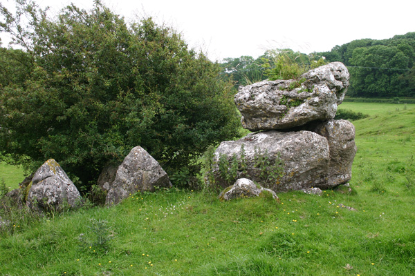
Great Urswick Burial Chamber submitted by ocifant on 26th Jun 2005. Looking south to the road.
(View photo, vote or add a comment)
Log Text: Great Urswick Burial Chamber, Cumbria: There is not much on the web about this site, and nothing (apart from a finger post in the vicinity) on ADS, apart from the fact this site is ‘ruined’ and ‘possibly Bronze age’. Parking on these narrow lanes was dreadful and were also very busy with traffic, so going round a bend you were likely to come bumper to bumper with a vehicle going the other way. When we finally found a grass verge with room for one car there was a large truck and a horse and rider stopped to natter to each other, so we drove around again – it would have been easier to walk from the village (also avoiding the bull in the field - see later).
The first part of the footpath across the meadows from Middle Barrow Lane was easy enough. There was a tumble-down stile, built up by a mound of stones on the far side (at grid reference SD 26018 7483). We then lost the footpath and ended up going through various fields towards the village.
We found a lone gate post sitting in a dip between two small hills. I thought at first it was a standing stone, but it had the remains of a hook embedded in it. Carrying on towards Great Urswick, there is a hill rising to the left hand side with limestone pavement on top. Walking up the slope the chamber comes into view, although I wasn’t convinced at first. The chamber lies within the context of surrounding limestone pavement, on a slope and largely consists of a few larger stones piled on top of each other with a gap between smaller stones lower down the slope. The whole chamber is mostly covered by large hawthorn bushes. I had to call up the photograph on the Portal to make sure we were looking at the right thing!
Walking back to the car, the footpath was clearly visible from this side, walking north westwards along the top of the hill. However, we were stopped dead in our tracks by a very large tan and white bull which splayed its front legs and stared us out. We turned quietly round and went back down into the shallow valley to follow the way we’d come. We found the footpath signs easily on the way back. There was an iron kissing gate in the hedge to our left hand side, followed by a short but steep climb into the field with the bull. Thereafter an easy walk to the burial chamber.
Great Urswick Cross
Date Added: 25th Jun 2015
Site Type: Ancient Cross
Country: England (Cumbria)
Visited: Yes on 23rd Jun 2015. My rating: Condition 3 Ambience 4 Access 5
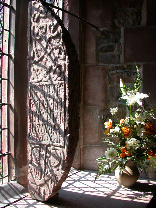
Great Urswick Cross submitted by nicoladidsbury on 5th May 2005. Ancient Cross at St Mary and Michael's Church, Great Urswick.
The stone was found on the site by a turn-of-the-century vicar and was investigated on the site by the respected historian WG Collingwood, and may possibly describe a meeting between two important church leaders, and church rune stone holds the key to a 1600 year-old story that reveals the origins of Christianity in Britain.
(View photo, vote or add a comment)
Log Text: Great Urswick/The Tunwini Cross, Great Urswick, Cumbria: Turning right off the A590 just south of Ulverston/Swarthmoor, along a road signposted only to ‘Urswick’, we headed off on narrow little lanes, just as the sun broke through the clouds. The village of Great Urswick is built round two sides of Urswick Tarn. The church can be found on the left/western side of the tarn, almost at the southern end of the village. A small car park allows visitors to draw up to the gate, where a footpath and stile runs off through the churchyard around the southern side of the tarn. Whilst the church itself is surrounded by trees, walking past the church to the southern boundary of the churchyard gives superb views over to Birkrigg Common.
Inside the church was pretty spooky, as the darkness seemed to suck all the light out. We found the light switches but none worked (must have been on a timer or master switch), so we were left to look around by the light of the few lamps that had been left on at the west end of the church.
Entering the church through the south porch, the Great Urswick/Tunwini Cross is on the first window sill on the south aisle, and is impressive in size. The church guide makes reference to two crosses; we were unable to find another fragment, although there was a drawing of another Viking cross with a knot design on the wall behind the font. The Furness Blog Spot, which I found this morning, tells me that this fragment is not on display in the church, but then doesn’t say where it is housed.
Going through the door to the belfry, we were immediately struck by the thickness of the walls, which was apparently a pele tower used to protect inhabitants and animals in time of war/marauders. In the chancel there are also some fantastic choir stall end carvings, all with cherubs playing different musical instruments.
At the entrance to the south porch there are clear marks on the eastern side where arrows have been sharpened, together with the remains of an old cow chain (the vicar used to apparently have grazing rights in the churchyard, although sheep are kept there now) and the barely visible remains of a mass hour dial on the western side of the porch.
Jarrow
Date Added: 22nd Jun 2015
Site Type: Ancient Cross
Country: England (Tyne and Wear)
Visited: Yes on 10th Jun 2015. My rating: Condition 3 Ambience 4 Access 5
Jarrow submitted by Thorgrim on 25th Oct 2004. Cross fragments
(View photo, vote or add a comment)
Log Text: Anglo Saxon Fragments, St Paul's Church and St Bede's Monastery, Jarrow: We parked at Bede’s World (a couple of hundred yards away from the church and the monastery) and having decided to start off at St Paul’s Church, we followed (or tried to follow) the signs, which took us across the busy main road to another car park. All the paths seemed to lead into the middle of no-where. After 10 minutes wandering around in circles with granddaughter in pushchair, I finally went inside to ask. The girls at the Bede’s World reception had to go and ask. “It’s straight through the park”, they told me. All the posters up in the reception area said the church was open until 15:30 so we thought we had plenty of time.
Not being able to get the pushchair down the ramp into the park (too overgrown) we followed the pavement along the main road down to the church, where we had to manoeuvre round tree cutters to follow the path up to the west porch. We were greeted by the ruins of St Bede’s Monastery on our right hand side – such an ancient building incongruously topped by modern pylons rising up behind.
It turned out the church was only open until 3pm so we only had 10 minutes to go in, wander round, take photographs and try and appreciate the history of what we were seeing. A volunteer came up to us and I waved the Corpus of Anglo Saxon stone sculpture pages that I’d printed off and explained I was on a ‘treasure hunt for Anglo Saxon cross pieces’. Instead, we got drawn into the old monastery chapel for a guided tour. The rest of the church seems, and feels, pretty ordinary, but this old chapel, dating from AD681 with its dedication plaque above the entry arch, was very moody and special. The lady pointed out the two pieces of original Anglo-Saxon glass in the south windows.
It also turns out that the fragments are now in display cases, rather than being displayed in the porches, which made them incredibly difficult to photograph, as the light coming through the church windows reflected in the glass, as did the flash when I tried to use it. By this point, they were turning the lights off in the church to go home, although they very kindly let us stay an extra 10 minutes so I could photograph some of the artefacts. Definitely a second trip needed when there’s more time to wander round the old church and the ruins of the monastery outside.
St Wilfrid (Melling)
Date Added: 18th Jun 2015
Site Type: Ancient Cross
Country: England (Lancashire)
Visited: Yes on 6th Jun 2015. My rating: Condition 3 Ambience 3 Access 4
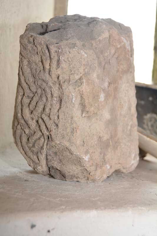
St Wilfrid (Melling) submitted by Anne T on 6th Jun 2015. We turned the stone round very, very carefully to see what the other two sides were like. It has obviously been recut at some point, and the British History Online notes say it was taken out the church wall a few years ago.
(View photo, vote or add a comment)
Log Text: Anglo Saxon Cross, St. Wilfrid's Church, Melling: From seeing the reconstructed cross at Halton, we set off back to Melling, to work our way back towards Levens Park/Sizergh Fell to end the day. Following the A683 back through Hornby, we drove through the village of Melling, with very narrow roads, and with cars and huge trucks trying to pass each other, it was a bit precarious to say the least. The church is on a very narrow section of Main Street, so we ended up parking in Gillison Close, having to turn right just past the church into a road that eventually turns into Lodge Lane. There was no footpath for 200 yards down this small road, which, given the amount of traffic on it, was exciting for pedestrians [note: there are steps up to the church, so disabled access is going to be difficult].
Formerly called St. Peter’s (but I haven’t been able to find out when the dedication changed), this pretty church is Grade 1 listed. The British History Online notes state that the church “stands on the west slope of an elevated plateau, the top of which forms an ancient earthwork known as Castle Mount”. This church looks ancient from outside but deceptively modern inside, apart from the tower. The ADS website was down at the time of writing this, but both Wikipedia and the “A Church Near You” website states that “the earliest fabric in the church dates from around 1300 or earlier ... it is possible that a church has been on the site since the 10th century.”
We found a fragment of Anglo Saxon cross tucked away on a window sill on the west interior wall, alongside a modern ceramic bowl and a piece of medieval grave marker. This short piece of cross shaft has basket-work interlacing which British History Online says was taken out of the churchyard wall a few years ago. Curiously, the on-line records of the Corpus of Anglo Saxon Stone Sculpture has only a one line mention of this stone, saying there are similarities with cross shafts found at Aspatria and Lancaster.
There is apparently a piece of Norman chevron ornament, found below the tower floor, which is now built into the vestry wall, but this was not accessible during our visit.
In the porch there are a couple of medieval grave markers displayed against the east wall. Outside, near the south wall, there is a very tall sundial, which must have been meant to have been read from horseback. It still has it’s (now green) brass plate on the top, but no gnomon. Wikipedia says it probably dates from the 18th century and is Grade II listed.
Sizergh Settlement
Date Added: 9th Jun 2015
Site Type: Ancient Village or Settlement
Country: England (Cumbria)
Visited: Yes on 4th Jun 2015. My rating: Condition 2 Ambience 4 Access 3
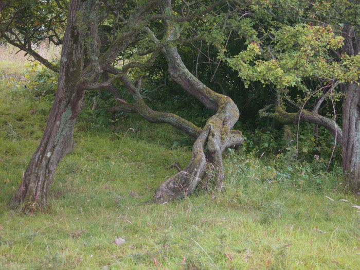
Sizergh Settlement submitted by Alphasmam on 1st Aug 2014. Sizergh Settlement is covered in trees but this tangle of branches adds to the ambience of the place.It is just possible to see the stone outlines in the grass underneath the trees.
(View photo, vote or add a comment)
Log Text: Sizergh Settlement and Cairns, Levens, Cumbria: I’ve spent more time trying to find out more about this intriguing site than all the others we visited today (4th June) as there seems to be so little about it, apart from on the Portal. I’ve tried to visit durhamnature’s ‘archive.org’ to retrieve the “Transactions of the Cumberland Arch Soc” but it’s given me no results (will try again when I’ve got a little more time to spend on this).
Getting here was another challenge for my map-reading skills. It should have been simple enough to reverse directions from Archer’s Hill, returning to the A591 and cutting west towards Levens, but were halted by a ‘no access’ sign. There were plenty of cars coming in the other direction and the road was even two-way, so we took a chance. How wrong could we have been? Almost reaching the end it became apparent that it led onto the dual carriageway heading in the other direction, so a hasty three point turn was made and we ended up following the minor road back past Leven’s Park, through Hincaster and heading back to the A6 to travel north for a short distance before turning off for Levens and heading back east towards Heaves Farm, just north east of Levens.
There was room to park the car by the footpath sign leading up past the western side of Middle Plantation, and we headed up the pleasant grassy track up the hill. To the right hand side there were a couple of gates and footpath signs leading up to the cairns and the circular structure we’d seen on the map. The sign on the first gate told us that the lumps in the grass weren’t grass covering stones as we’d first thought, but ant-hills that were formed on pastures that weren’t mowed. Interesting – never seen these before.
As we walked further up hill, there was a very intriguing (favourite word of the day) circular mound covered in trees (the rest of the fields had no trees at all). As we passed this to our left hand side, the larger of the two cairns rose up at the top of the hillside. There were glorious views over the fells to the north. Heading off to the west, there was a small quarry face with lots of stone chippings. Having photographed this, together with the sheep curled up on the warm limestone, we headed off into the wooded mound. Largely covered in hawthorn trees, it was interesting to navigate the low branches. There was some bedrock peeking through the grass, but also circular structures and also two sides of what had been a rectangular stone building.
Having arranged to meet some friends in Penrith on the way back, we made our way back down the mound to see if we could spot the smaller of the two cairns. Yes, it was there, but rising only 10 to 15 cms above the ground. Our eyes could make out the circular structure but it was difficult to photograph, with no shadows to bring out the mound.
Certainly a lovely spot, and I’m keen to find out more. Getting home and hitting the internet, I ended up getting very confused between this site and a Romano-British Settlement excavated by Oxford Archaeology, but checking the grid references confirmed they were different sites in close proximity. In the end, husband Andrew managed to find the extract below from a free Google book and I found a reference on the British History Online records:Discovering Prehistoric England: A gazetter of prehistoric sites by James Dyer, A Shire Book
Take minor road NE from Levens. The sites are to the N of the road on Sizergh Fell. The site consists of an oval embankment enclosure covering 0.2 hectare, with secondary enclosures to the south. Interior hollows may indicate the sites of hut circles. On the hilltop there is a small round cairn, 7.5 metres across, which contained a collared urn. To the east a further cairn, 9 metres across and 0.9 metres high, covered 5 skeletons."
Leven's Park ringcairn
Date Added: 9th Jun 2015
Site Type: Ring Cairn
Country: England (Cumbria)
Visited: Yes on 4th Jun 2015. My rating: Condition 2 Ambience 4 Access 4
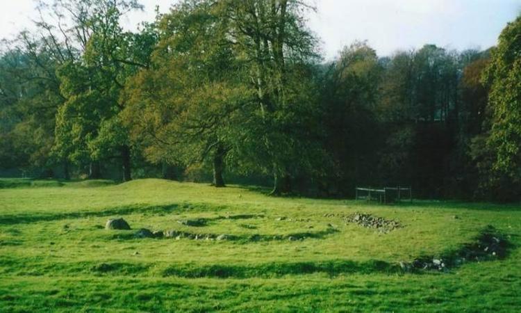
Leven's Park ringcairn submitted by Bladup on 11th Nov 2014. Leven's park (Archers hill) ringcairn.
(View photo, vote or add a comment)
Log Text: Leven's Park/Archer's Hill Ringcairn, Cumbria: This cairn is close to the roundabout where the A590 meets the A591 and A6 just south of Sizergh Castle. My map reading failed, as the junctions were complicated – no proper roundabouts, just adjoining roads with ‘give way’ signs to transfer from one carriageway to the other, which was fun at 5pm with traffic whizzing everywhere as everyone escaped from work to home. After a few wrong turns, eventually we made it onto the minor (brown) road which runs between Sedgwick and Hincaster, stopping at a small car park (enough room for 3-4 cars) outside a stile over a stone wall leading into Leven’s Park. By the stile, a small stream joining the River Kent tumbled over stones downhill and the trees provided welcome shade.
Walking along the dirt track for a couple of hundred yards, the cairn is to your right hand side, not in view from the path, but in a very pleasant spot, next to the River Kent. Between the dirt track and the actual cairn there is a series of four smaller mounds – possibly either cairns in their own right? -but I could find no mention of these anywhere on Pastcape or any other source. We did look for the mentioned field system around the ring cairn, but could find no evidence of it.
Walking round this ring cairn, there are clearly two different rings, which originally intersected, but give the appearance of now being joined into one larger cairn. Trying to capture the two different rings, we headed up the hill to the south west.
Red Well, Barnard Castle
Date Added: 7th Jun 2015
Site Type: Holy Well or Sacred Spring
Country: England (County Durham)
Visited: Yes on 2nd Jun 2015. My rating: Condition 4 Ambience 4 Access 4
Red Well, Barnard Castle submitted by durhamnature on 6th Sep 2012. The stone-built shelter and bench seat.
Site in County Durham England
(View photo, vote or add a comment)
Log Text: Red Well, Barnard Castle: Before leaving home late this afternoon, I'd done a quick trawl of what information could be found on the Red Well on the internet, and come across a curious document entitled: “Archaeo-Environment Ltd: South West Durham Heritage Corridor, Volume II Journeys Part 2” in which page 170 (actually page 3 of the document) talked about “Dr. Edwards’ Health Restoring Walk: a route walking from the rail path into the centre of Barnard Castle viewing Dr. Edwards’ natural springs and former railway building”. It then talks about “this circular route leaves the main railway line behind Glaxo and uses existing rights of way (not bridleways) to visit Barnard Castle via the Red Well. Red Well is an attractive 19th century spring located within its own enclosure. It was popularised by Dr. George Edwards who encouraged the residents of Barnard Castle to make use of its health-giving properties ‘Its valuable laxative qualities has, I know, been ascertained. The Red Well was named from the colour of the stain left on the stone over which the mineral spring flowed (Wilkinson 1998, 46). It no longer stains the stone and is not recommended for drinking .... Access to the enclosure today is by an old metal kissing gate which contributes towards local historic character. Inside the enclosure a stone shelter with seat provides views towards Glaxo buildings, but would had originally viewed the railway line. Overgrown with wildflowers rendering the path virtually invisible, the Town Council are only able to mow it once a year. A path was constructed originally in a horseshoe shape around the edge of the enclosure linking the well with the seating area.”
Leaving Barnard Castle along Galgate (the A688 towards Darlington), then peeling off along Harmire Road (the B6278) we drove past the Glaxo buildings. We had difficulty in spotting the footpath signs, as they were either very tiny rectangular shaped or just below the level of the stone walls/shrubs along the sides of the road. In the end we parked along the road into Montalbo Industrial Estate and walked back, crossing (the now busy road, as it was factory closing time), and easily found the footpath which followed the small stream through the grassy meadows on the opposite side of the road.
By this time, the wind was howling and heads down, we started through the field that had a “Bull In Field” notice on the kissing gate (there wasn’t this time, we checked thoroughly before crossing). In the second field we were mugged by the sheep who came baaing and running at us, probably thinking we’d brought them sheep nuts or some other treat. They were disappointed, and when we crossed back, they pointedly ignored us.
A metal kissing gate leads into the enclosure with the Red Well in it. The well/spring certainly has a good output, water streaming from the outlet pipe. The sign inside the stone shelter is curious – there was obviously a ‘battle’ of some kind over the well in the past. Need to find out more, but most of the internet enquiries come up with ‘Red Well Inns/Hotels/Pubs – will find time to look further soon.
Not the best of locations for the well now, with its views over Glaxo Smith Kline buildings and the wind turbines, but on the edge of town and surrounded by meadows and sheep.
We had to really battle the wind going across the meadows back to the car, and were glad of its shelter once we’d arrived. Shame, because whilst it was sunny, the wind meant we didn’t linger at this spot. It was now early evening, so back home, via Staindrop to find the Anglo Saxon Cross fragment.
St John the Baptist (Tunstall)
Date Added: 7th Jun 2015
Site Type: Early Christian Sculptured Stone
Country: England (Lancashire)
Visited: Yes on 4th Jun 2015. My rating: Condition 3 Ambience 3 Access 5
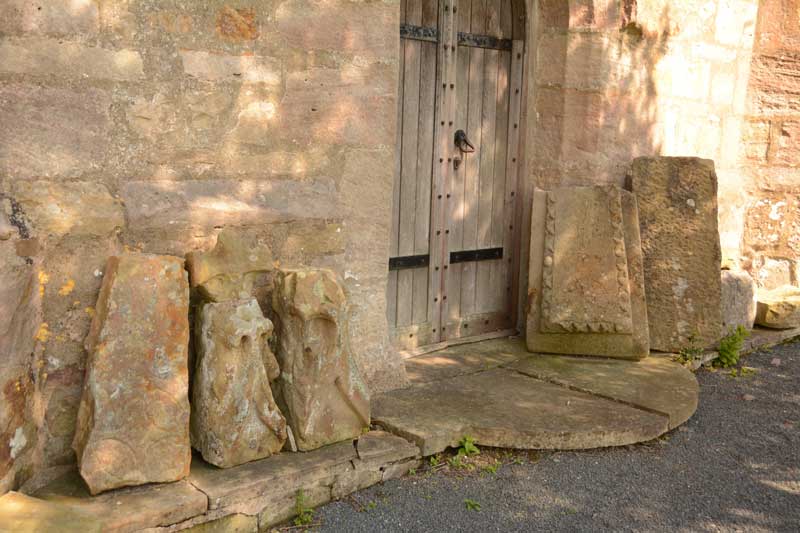
St John the Baptist (Tunstall) submitted by Anne T on 7th Jun 2015. We searched and searched for the Roman altar, but couldn't find it. Outside the west door, there is a display of architectural stones, including medieval grave markers and what looked like a very worn Anglo Saxon Cross Head/Finial.
(View photo, vote or add a comment)
Log Text: Votive Stone, St. John The Baptist, Tunstall: Driving from St. Wilfrid’s, Melling, we continued north along the A683. Just mile or so along the road, the A683 becomes a ‘minor road’ splitting off to the left, whilst the main carriageway continues as the A687. Following the A683 into Tunstall village, Church Lane is the last turn to the right hand side, almost at the end of the village. This road disappears into green fields with a few large houses along the way. After about 600 metres, the church appears to your left hand side, with parking places outside the entry stile. This is a glorious country setting with a beautifully looked after churchyard.
The ADS web site was down at the time of writing, but the British History Online notes are really helpful, telling me that this church, now named St. John The Baptist, used to be dedicated to St. Michael, and is largely of “15th century date .... there are some remains, however, of a 13th century structure, fragments of which have been used in the rebuilding”.
The church guide was £5, so we didn’t buy it, but quickly looked through it to find it mentioned a Roman altar as well as the votive stone, but no clues as to the whereabouts of either - I had to use my phone to find out where the votive stone was; we found no suggestion of the Roman altar, although there was a display of architectural pieces and medieval grave markers by the west door which included what looked like a very worn Anglo Saxon cross head.
To assist future visitors, the votive stone is on the eastern-most of the three windows (nearest to the organ), on the left hand side of the window surround. Curiously, it has been placed on its side.
At the east end of the south aisle there is a small chapel which contains a much broken effigy, said to be of Sir Thomas Tunstall. There is also an ancient chest just outside the south chapel and outside a sundial shaft which stands on three octagonal steps.
Halton St Wilfrid's Churchyard
Date Added: 6th Jun 2015
Site Type: Ancient Cross
Country: England (Lancashire)
Visited: Yes on 4th Jun 2015. My rating: Condition 3 Ambience 3 Access 5
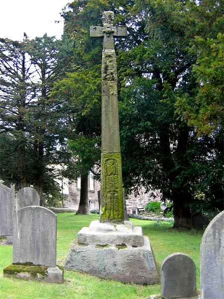
Halton St Wilfrid's Churchyard submitted by LivingRocks on 18th Apr 2005. The partially restored high cross in St Wilfrid's Churchyard.
(View photo, vote or add a comment)
Log Text: Ancient Cross, St. Wilfrid's, Halton: From St. Margaret’s in Horby, we followed the busy A683, turning off onto the road to Halton just south of Caton. Although only a side road, this road seemed busier than the main road.
This must be one of the most dangerous sites I’ve visited. The church is located on a bend on this busy, busy road and the gate into the church is less than a foot from the edge of the road with no pavement, and it’s quite stiff to open – nearly got run over trying to get into the church and had to be very careful exiting, as you couldn’t see what was coming round the bend to the right.
The church looks more like a house with a stone tower, and unfortunately was locked, which was a shame, because the Pastscape record tells us there are pieces of 5 Anglo Saxon stones built into the interior of the tower.
According to the Pastscape record 41153, the pre-Norman cross (restored in 1890) tells the story of the Sigurd legend (which I’ll need to find out about), although to my eye not all the pieces matched and must be several crosses amalgamated together. A bit of a disappointment really.
St Margaret (Hornby)
Date Added: 6th Jun 2015
Site Type: Ancient Cross
Country: England (Lancashire)
Visited: Yes on 4th Jun 2015. My rating: Condition 3 Ambience 4 Access 5

St Margaret (Hornby) submitted by Anne T on 6th Jun 2015. The smaller fragment contains chevron patterns on its upper part and some form of scroll work on its lower section.
(View photo, vote or add a comment)
Log Text: Anglo Saxon Cross Fragments, St. Margaret's Church, Hornby: From Gressingham, we continued east along the twisty-turny Back Lane, over the narrow bridge over the River Lune, to its junction with the A683. Turning right, we were almost immediately in Hornby. St. Margaret’s sits on the left hand side of the road, before the main road takes a right hand turn. There is ample parking on the right hand side of the road opposite the church which is distinctive with its octagonal tower.
Opening the gate from Main Street, you fall into the porch of the church, which is very dark. Inside, the church appears very modern and (to me) without personality, although there is evidence of much older structures such as the traces of old roof lines in the interior west wall; Pastscape records it as having building having started in 1514, with the nave being rebuilt in 1817 with clerestorey being added in 1889.
There was no church guide, just one board with an A4 sheet of notes. This told us that: “Under the tower are two fragments of 9th century crosses, one showing the five loaves and two fishes; this is unique in England, though there are two in Ireland. They both came from the Priory ...”, although the Pastscape record says they are 8th to 9th century and that both fragments had been reused in a 19th century barn wall at Priory Farm before coming to the St. Margaret’s. The church notes continued: “The churchyard contains a huge cross base, which may be pre-Conquest or Norman. The original cross could have been twelve feet high. Its presence is something of a mystery.”
The Anglo Saxon Cross Fragment with the carving of the five loaves and two fishes was impressive, and definitely worth stopping to see. Alongside it, to the right, was a much smaller fragment with chevrons.
The churchyard is beautifully kept, with well mown grass and shrubs being clipped into amazing shapes and kept low to the ground. The cross base is huge in comparison to others that I’ve seen – I had to climb on top of a stone to photograph the top, which has a slot for a cross to go into on top.
St John the Evangelist (Gressingham)
Date Added: 6th Jun 2015
Site Type: Ancient Cross
Country: England (Lancashire)
Visited: Yes on 4th Jun 2015. My rating: Condition 3 Ambience 4 Access 5
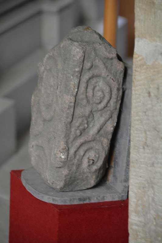
St John the Evangelist (Gressingham) submitted by Anne T on 6th Jun 2015. A photograph showing the side of the cross fragment inside the church. As it was securely fastened to the wall, I was unable to turn it round to photograph the reverse side.
(View photo, vote or add a comment)
Log Text: 9th Century Anglo Saxon Cross Fragments, St John The Evangelist, Gressingham: Having decided upon a day out in Lancashire/Cumbria on an Anglo Saxon Cross hunt, this was our stop of the day. We approached from junction 35 of the M6, taking the B6254 through Over Kellet and taking a right hand turn, named Fall Kirk, down to Gressingham. This is a pretty little village with the church on the junction of Fall Kirk and Back Lane, sited on a hill next to a small stream which joins the River Lune to the south. Not having phoned through before visiting, we were delighted to find the church open, with a lovely Norman arch over the entrance door on the south wall. But whilst it was warm and sunny outside, this Grade 1 listed church was cold inside.
Whilst the Pastscape and Wikipedia notes talk about more than one fragment of 9th cross inside the church, we could only spot one, despite a thorough hunt by both of us. This was strapped into the north-east corner of the nave, just before a large tomb for George Marton, so I was unable to turn it round to photograph the reverse side. The 9th cross shaft built into the external south-west corner of the nave was easy to spot, with the sunlight picking out the decoration nicely [note: having reviewed the Pastscape notes, another fragment might be inside the vestry, which we didn't check].
There was a pulpit of dark wood dated 1714 on the south side of the church, and retained some of the original box pews. There was also a tapestry on hessian against the south wall, opposite the chest tomb and the stone fragment which caught my imagination – someone has put a lot of hard work into this.
Preston Cleugh Fort
Date Added: 3rd Jun 2015
Site Type: Hillfort
Country: Scotland (Scottish Borders)
Visited: Yes on 30th May 2015. My rating: Condition 2 Ambience 4 Access 4
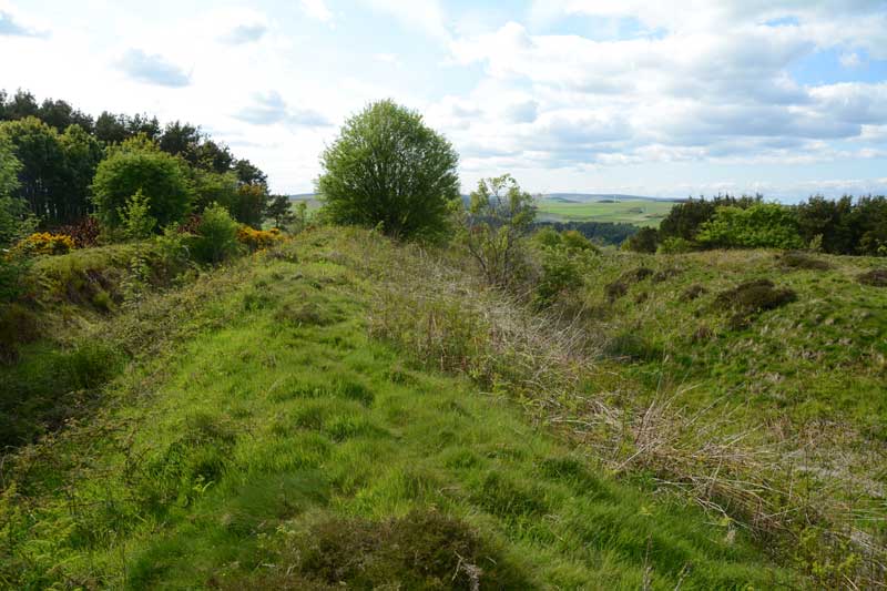
Preston Cleugh Fort submitted by Anne T on 2nd Jun 2015. Standing at the south east corner of the fort looking west.
(View photo, vote or add a comment)
Log Text: Preston Cleugh Fort, Scottish Borders: On our way to Edin’s Hall Hill Fort & Broch, having stopped in Duns for a late lunch, this fort was right next to the road on our way, so we decided to stop and take a closer look. Taking the A6112 through Preston, just after where the B6438 forks off the A6112 on the right hand side, there is a forestry track leading into Preston Plantation, where it’s possible to park against the verge along the edge of the track, close to where it meets the main road. There were signs all along this track saying ‘Entry Prohibited’, ‘Forestry Operations’, ‘Do Not Climb On the Timber Stacks’, but only a short way up this forestry track was a sign saying the ancient monument was 127 metres away. Stepping over a small bank and wading through growing ferns and weeds (which will be knee high in a few weeks), the double bank of the fort rose out of the ground before us. These defensive banks and ditches continue along the west and south sides, the north and east being formed by natural slopes.
There is a clear entrance-way to the north western side. To the north east, Cockburn Law Hill Fort rises high above this fort.
The Canmore site notes (site 58616) say that this fort measures 77m by 57 metres internally, having been built in two phases: the first phase being a double earthern rampart and ditch with its entrance on the western side; the second included the construction of a stone rampart on the line of the inner rampart, continuing along the entire perimeter of the fort, with a new entrance being cut on the eastern side.
A peaceful spot, worth stopping off to visit, particuarly with a print of the plan from the Portal 'Drakemuir Forts' to understand what we were seeing. Thanks, Portal, another good place to visit.
The Sleepy Sheep, Deepdale
Date Added: 3rd Jun 2015
Site Type: Natural Stone / Erratic / Other Natural Feature
Country: England (County Durham)
Visited: Yes on 2nd Jun 2015. My rating: Condition 4 Ambience 4 Access 4
The Sleepy Sheep, Deepdale submitted by durhamnature on 28th Jun 2012. The Sleepy Sheep, a pink granite glacial erratic beside the River Tees.
(View photo, vote or add a comment)
Log Text: The Sleepy Sheep Stone, Natural Erratic near Barnard Castle: Having decided to go to see Egglestone Abbey, I did a quick trawl on the Portal to see what else was nearby around Barnard Castle. The Red Well and this stone looked intriguing so I printed off the pages, and off we set. [Thanks to Durham Nature for this entry – I’ve since looked up his web site and will dip into this again.]
On the way back from Egglestone Abbey, instead of turning right along The Sills to go over the road bridge over the Tees into Barnard Castle by the castle, we went straight on along Lartington Lane. Whilst it’s a relatively minor road, it is wide but busy along its first part, with Hensall Way peeling off and leading up to HM Young Offenders Institute Deerbolt. Not sure which side of the river the stone was on, we parked on a wider section of the road near Deepdale Cottage, just along from the junction with Henshall Way. We walked back along the narrow pavement to Deepdale footbridge over the river to its northern banks, but drew a blank. From the image from the Portal, the stone was most likely to be on the southern side of the river, so we trekked back over the footbridge (distressingly the wooden sheets across the bridge were all rotten and cracking, and plastic reinforcement had been laid across some parts).
Finding the entrance to the park on the southern banks of the Tees between two cottages, we opened (and closed) the gate and followed the metalled road along the grassy meadow. In a couple of hundred yards I said to Andrew, “either that’s a sheep that’s keeping very still, or it’s the stone.” It was the stone.
The shape of this natural erratic is indeed like a sleeping sheep. Made definitely of red Shap granite, it was so cute! We wondered how on earth it had got there. The Durham Nature web site tells us that there are a number of these erratic in the area, pushed over the Pennines by a glacier during the last ice age. I definitely want to go and find the others at Deepdale and The Mortham Stones.
The location is also very pretty, sleeping between the small road and the river with lush, green grass blowing in the breeze and sheep with their photogenic lambs standing watching what we were doing.
The winds were definitely getting stronger by this time (pity my friends walking from John O’Groats to Lands End who are up around Shap today!) so set off to find The Red Well, then onto Staindrop to find the Anglo Saxon Stone Fragment on the way back.
Edin's Hall
Date Added: 2nd Jun 2015
Site Type: Broch or Nuraghe
Country: Scotland (Scottish Borders)
Visited: Yes on 30th May 2015. My rating: Condition 3 Ambience 4 Access 3
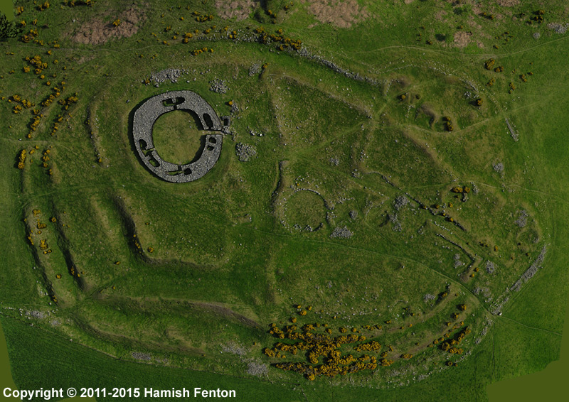
Edin's Hall submitted by h_fenton on 30th Mar 2015. Edin's Hall Broch / Fort / Settlement. Vertical image from 3D model which was created using 75 Kite Aerial Photograph s.
Photos taken: 19 May 2011
3D model created: March 2015
(View photo, vote or add a comment)
Log Text: Edin's Hall Fort & Broch, Scottish Borders: Having stopped at Duns for refreshments, there is a small car park, large enough for 3 to 4 cars just off the A6112 at grid reference NT 78933 60957 which gives access to a forest/river walk. At the car park, there is a signpost for the Broch, saying ‘2 ¼’ but two and a quarter what? Miles, kilometres? This contradicted our map which indicated the walk was just over a mile.
Walking through woodland, along an easy forest track, there is a sign saying: ‘Free range children and animals’ so whoever owns this land has a sense of humour (also try and spot the tree with personality by the car park - it has been given eyes, ears and a nose!).
Down the path, we approach the Whiteadder Water (yes, there is also a Blackadder) we come across the Elba foot suspension bridge, with a sign saying ‘only two people to cross at any one time. No jumping on the bridge’. It indeed moves up and down as you walk over. There are stunning views of vertical bedding planes forming the banks of Whiteadder Water at this point, with water tumbling over the rocks.
Continuing past the house, through its orchard, past the barking dogs and geese and hens, onto the flood plain with a bank to our left hand side which keeps the curious cattle at bay, we followed the river. Climbing up the bank towards the pylons running overhead led onto two stiles (stone steps) over the stone walls. This was somewhat of a challenge for me on the way there, having to sit on top of the wall and swing my legs over, but on the way back, I’d got bored of being frightened and actually managed to walk across them like a normal walker.
A pleasant walk up to the hill fort and broch, with a herd of cattle looking lazily down on us from the top of the hill in the first field and a flock of sheep and their now large lambs in the second. Rather than scramble across a third stile there is a gate in the wall higher up the slope which we used to gain entry to the field with the fort. The Duns History Society describe this walk as ‘slightly strenuous’ but I’d disagree. It’s pleasant enough, although the hillside immediately up to the fort is a little steeper in practice than it looks on the ground.
Following the track into the fort, there are some obvious defensive banks and ditches which rise gently up the hillside as you follow the trackway, with clear hut circles, large and small. There also appears to be the remains of some square stone structures which (according to the interpretation board) indicate later (more recent use of the site). The views down to the river valley were great, as was Cockburn Law Hill Fort rising still high above us – we drove past this on the way back to Abbey St. Bathans and will come back to explore this on another visit [note to self, use the A1 to Berwick then cut across country to Preston rather than use the A697 road from Morpeth – this was very slow].
The broch itself is impressive as you first approach – the entire lower few courses of stone are still in place round the entirety of the circular structure; there is only one entrance into the broch on its eastern side.
It is fascinating to walk around, as there are all sorts of internal chambers, and even the beginnings of a small set of stairs in an internal chamber on the south-western side of the broch. On the north-western side, where the ground starts to slope away towards Whiteadder Water, the walls are particularly thick; we guessed this was either because the walls needed reinforcing at some point to stop them sliding down hill, or it’s an internal chamber that’s been filled in.
The late afternoon/early evening sunshine brought out the contrast between the defensive banks and ditches and I could have spent a lot longer walking around here. If there had been time, we might have followed the footpath through the west-south-western entrance to the fort all the way up to Cockburn Law Hill Fort. The site appears to be really well cared for, with all the bracken being cut back.
Dodlaw Burn
Date Added: 26th May 2015
Site Type: Standing Stone (Menhir)
Country: Scotland (Scottish Borders)
Visited: Yes on 23rd May 2015. My rating: Condition 3 Ambience 4 Access 3

Dodlaw Burn submitted by Anne T on 26th May 2015. Standing behind the 'entrance pair' of stones looking west over the Kale Water valley.
(View photo, vote or add a comment)
Log Text: Dodlaw Burn Standing Stones and Cairns, Scottish Borders (alternative name = Chatto Hill Standing Stone): I guess we’ve become more than a little bit fascinated by this part of the Scottish Borders, probably because it’s easy to get to (about an hour from our house), there are very, very few people around (apart from the odd farmer and cyclist) and there are so many features/sites marked on the map.
Husband Andrew spotted an area marked on the map as having ‘standing stones and cairns’ relatively near to Woden Law hillfort, which we both wanted to see. So, on a sunny Saturday, we set off north.
Taking a different route from Jedburgh through Oxnam, we ended up back at the Pennymuir Roman Camps, continuing past them up towards Chatto Craig and Tronshaw Hill. The minor road passes over a cattle grid near Chatto/Upper Chatto, and immediately over the grid there is a sheep-fold with room for several cars to park without blocking access to the field.
A gate gives access onto the field from here and the track climbs up and off to the left hand side of the field, up past a small wood to the left hand side then levels off in the area between Dod Law hill to the right and Little Heuch Law to the left. Almost immediately, we were struck by what appeared to be cairns on the eastern flank of Dod Law and in the flat area to the left hand side of the track, what could possibly be a large hut circle and a cairn or two. Because of the depth of the tussocked grass, we could walk the bank of the ‘hut’ but couldn’t really capture it in a photograph. More research to done on the RCAHMS site in this area, me-thinks (there are lots of ‘dots’ on Canmore mapping here, but you can’t click on a dot and bring up the information, so it’s going to take some time). We did take grid references, and I’ll look at these when there is more time (and less gardening) to do. (Note: a subsequent look at the Canmore site reveals this circular feature is a most probably a sheepfold).
Continuing up the gently slope between the hills and crossing over the small ford over the Dod Law Burn, the standing stone appears on the brow of the hill just above you. Following the path, it becomes clear on reaching the top that there are three stones; two sit close together as a sort of entrance. The third sits low and flat to the ground to the east.
There are in fact three cairns to the north of the third stone, at grid references NT 77795 16810 (measures 5.6 metres in diameter, 0.4 metres high), NT 77800 16814 (immediately to the north east, 4 metres in diameter and 0.4 metres in height), and NT 77799 16820 (to the north, 4.6 metres in diameter and 1.5 metres in width). I’m glad we had the GPS device. None of the cairns could easily be photographed, but we could definitely see them with the naked eye. Whilst the 1999 record says they stand 0.4 metres above the land surface, I reckoned they were about 20 cms higher, probably because of the tussocks of grass around them. Thank goodness for having taken part in the Davy’s Lee Level 1 and Level 3 surveys recently, as I began to get my eye in to look at lumps and bumps and identify changes in grass height and colour, which gave clues as to the banks surrounding the cairns.
Above us to the east rose a cairn on Little Heuch Law.
Woden Law
Date Added: 26th May 2015
Site Type: Hillfort
Country: Scotland (Scottish Borders)
Visited: Yes on 23rd May 2015. My rating: Condition 3 Ambience 5 Access 3
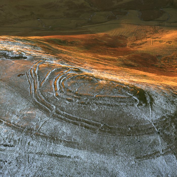
Woden Law submitted by dodomad on 8th Jan 2005. Aerial view of Woden Law fort, Scottish Borders. SC677288
Crown Copyright: RCAHMS
(View photo, vote or add a comment)
Log Text: Woden Law Hillfort, Scottish Borders: Firstly, congratulations are due to husband, Andrew, for getting me up onto this high, remote and very beautiful spot. The climb was certainly very worth it!
Driving back down from Dod Law/Chatto Hill, we arrived back at Pennymuir Roman Camps, turning left down the minor road passing Towford Outdoor Education Centre. Splashing through the ford through the wonderfully meandering Kale Water, we parked just before the t-junction a couple of hundred yards further on (there is room for 2 cars). Dere Street ran in both directions to our right hand side, doing a dog-leg past the camps and back up towards Trestle Cairn to the north-west, and running east-south-east, heading up into the gap between the hills of Hangingshaw Hill/Langside Law to the left with the impressive Woden Law to the right. Those Romans certainly knew a trick or two, as the road followed the lowest angle up the slope.
Setting off, I could hear a dog barking and eventually spotted two people descending the steep western slope of Woden Law with their three dogs. We kept to Dere Street.
At the top of the gap between the hills a small building was visible to the left of Dere Street, and heading towards this it was a slow, steady climb up easy grassy paths with the ditches of the road visible in parts. Just before reaching the building, at this point, it wasn’t clear if we could get through the newly built wire/barbed wire fence across the fields at this point(we've had problems of long stretches of fence lines with no gates before) so rather than go through the gate and follow the path, we trudged straight up the side of Woden Law which was rather steeper than it initially looked. I almost lost my nerve on this slope, having to step between tussocked lumps with holes in between. We soon reached the first bank and ditch of the Roman siege works on the lower slopes of the eastern side of the hill fort – but still about fifty feet below the summit. It became clear we should have kept to the path which was wide, grassy and easy walking!
Passing through a further set of fortifications, we reached the top of the hill. There was clearly a lot going on here – lumps and bumps and banks and ditches everywhere. Since coming home, we found the 1950 Excavation Report by the late Sir Ian Richmond and Professor St. Joseph, which has a plan of the fort in it. It would have been useful to have had this during our visit as we could have interpreted more of what we were seeing at the time, but has helped when cataloguing my photos. We started at the northern-most edge of the fort and worked our way over to the southern edge, taking note of the ramparts and structures on our way. At one point we noticed the rabbits had burrowed into the outer bank of the outer annexe and saw the high built up of turf on top of the stones used to create the wall.
The wind was persistent, and I was too much of wimp to go to the very edge of the fort, so Andrew took a few photographs perched on the outer bank.
Most definitely worth well the climb. Andrew wished he'd had his hang-glider.
Jedburgh Ancient Christian Stones
Date Added: 24th May 2015
Site Type: Ancient Cross
Country: Scotland (Scottish Borders)
Visited: Yes on 4th May 2015. My rating: Condition 3 Ambience 4 Access 5
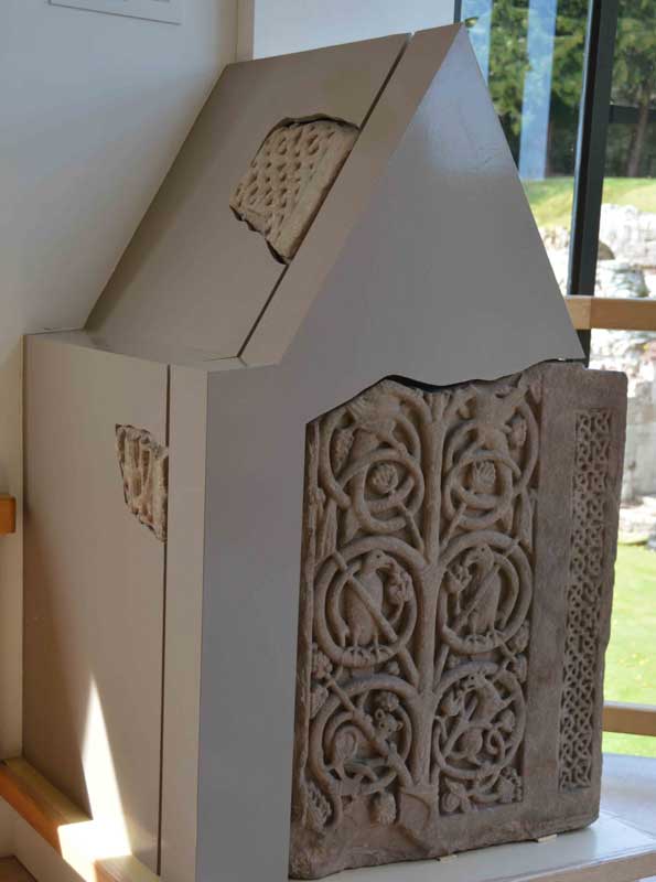
Jedburgh Ancient Christian Stones submitted by Anne T on 8th May 2015. The impressive 8th century shrine with its intricate carvings, displayed on the first floor of the Visitor Centre adjacent to the Jedburgh Comb.
(View photo, vote or add a comment)
Log Text: Jedburgh Early Christian Stones: We've driven past Jedburgh, with the Abbey looming high on the hill to our left, on many an occasion but never stopped to take a closer look.
Turning left into Jedburgh, we were surprised to find that not only was the parking free, but there was free Wi-Fi throughout the town (although the password to connect varies as to the cafe/facility you are using at the time).
Paying the fee to get into the Abbey, we entered the Visitor Centre, and was astonished (and pleased) to find Anglo-Saxon cross fragments displayed on the walls of the stairwell and also on the first floor. These hadn't been mentioned on their website, and were definitely a nice bonus.
Having photographed the early Christian stones (including the wonderful 8th century shrine fragments) we made our way into the Abbey. I love looking at old monasteries and churches and really enjoyed our time here. It was sunny and warm, and we amused ourselves for a little while by trying to re-create a couple of the photographs in the guide book (almost, but not quite - I'm not that talented!).
No refreshments in the Abbey/Visitor Centre but a string of nice cafes opposite.
I would like to come back when the various museums are open. There is a lot to see in and around the town.
We cut the visit reasonably short as we wanted to head out into the hills to look at Standing Stones not too far away.
Would definitely recommend a visit.
Horseshoe Wood Settlement
Date Added: 24th May 2015
Site Type: Ancient Village or Settlement
Country: Scotland (Scottish Borders)
Visited: Yes on 4th May 2015. My rating: Condition 2 Ambience 4 Access 3
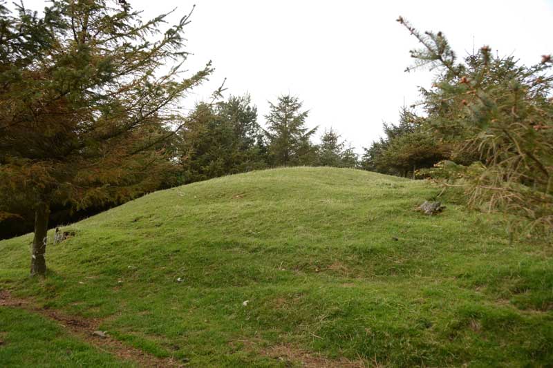
Horseshoe Wood Settlement submitted by Anne T on 9th May 2015. From a different angle the mound appears to have tiered banks which run around it (although always happy to be corrected as to what these features are).
(View photo, vote or add a comment)
Log Text: Horseshoe Wood Settlement, Hownam, Scottish Borders: After having parked in the sleepy little hamlet of Hownam, a footpath called The Street sets off near the village/community hall, leading off to the left of the main road up into the hills.
Just starting up The Street, there is a field to the right hand side of the road which holds what looks like another standing stone, so we stopped to investigate.
Continuing, we then passed a couple of houses on a gravelled roadway the footpath enters farmland which rises reasonably gently up towards Horseshoe Wood. At the time of our visit, the footpath was covered in manure (obviously had a herd of cattle on it recently). The lambs were very curious as to who these strangers were who were walking through their land, only moving from the warm soil of the path at the very last minute.
Horseshoe Wood runs to the left of the footpath, contained within a stone wall. Towards the higher end of the wood the wall has been demolished in two places and through this the mound of the settlement rises distinctly behind it.
Exploring, we found it to be an elongated mound, made even clearer by the fact it has no trees growing on it, with two circular scoops taken out of the left hand side; the first has a small tree growing out of it.
Curious, as this mound is relatively near the Standing Stone (only a couple of hundred metres), we took photographs and tried to find out more after our visit, but couldn't - but the description sounded identical to the RCAHMS/Canmore record of a scooped settlement nearby.
We thought perhaps this mound had been missed because it has been hidden by the wall and the trees within the wood.
If anyone can shed any further light on this mound, I'd be delighted to hear more.
