<< Text Pages >> Gunthorpe Henge - Henge in England in Nottinghamshire
Submitted by Bladup on Thursday, 08 May 2025 Page Views: 385
Neolithic and Bronze AgeSite Name: Gunthorpe HengeCountry: England County: Nottinghamshire Type: Henge
Nearest Town: Nottingham
Map Ref: SK6787044570
Latitude: 52.994168N Longitude: 0.990281W
Condition:
| 5 | Perfect |
| 4 | Almost Perfect |
| 3 | Reasonable but with some damage |
| 2 | Ruined but still recognisable as an ancient site |
| 1 | Pretty much destroyed, possibly visible as crop marks |
| 0 | No data. |
| -1 | Completely destroyed |
| 5 | Superb |
| 4 | Good |
| 3 | Ordinary |
| 2 | Not Good |
| 1 | Awful |
| 0 | No data. |
| 5 | Can be driven to, probably with disabled access |
| 4 | Short walk on a footpath |
| 3 | Requiring a bit more of a walk |
| 2 | A long walk |
| 1 | In the middle of nowhere, a nightmare to find |
| 0 | No data. |
| 5 | co-ordinates taken by GPS or official recorded co-ordinates |
| 4 | co-ordinates scaled from a detailed map |
| 3 | co-ordinates scaled from a bad map |
| 2 | co-ordinates of the nearest village |
| 1 | co-ordinates of the nearest town |
| 0 | no data |
Internal Links:
External Links:
Henge in Nottinghamshire
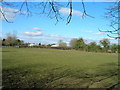
An earthwork enclosure interpreted as possible Late Neolithic/Bronze Age henge or medieval ringwork. A substantial circular enclosure defined by a broad ditch 15 metres wide and 1.5 metres deep, and a possible outer bank 5 metres wide and 0.75 metres high. Approximate diameter (excluding the possible bank) is 85 metres. There is a clearly defined south eastern entrance with very regular, squared ditch terminals. The site is scheduled as a henge, although in the absence of firm evidence, alternative interpretations, such as a medieval ringwork, cannot be ruled out. Immediately outside the ditch there is a possible bank showing as a paler band of grass.
The western side of this site is not visible as it is obscured by a hedge boundary. However, the line of this boundary curves at this point possibly reflecting the original shape of the ditch/bank
You may be viewing yesterday's version of this page. To see the most up to date information please register for a free account.
")
Do not use the above information on other web sites or publications without permission of the contributor.
Nearby Images from Geograph Britain and Ireland:
©2010(licence)
©2007(licence)
©2013(licence)

©2023(licence)
©2010(licence)
The above images may not be of the site on this page, they are loaded from Geograph.
Please Submit an Image of this site or go out and take one for us!
Click here to see more info for this site
Nearby sites
Key: Red: member's photo, Blue: 3rd party photo, Yellow: other image, Green: no photo - please go there and take one, Grey: site destroyed
Download sites to:
KML (Google Earth)
GPX (GPS waypoints)
CSV (Garmin/Navman)
CSV (Excel)
To unlock full downloads you need to sign up as a Contributory Member. Otherwise downloads are limited to 50 sites.
Turn off the page maps and other distractions
Nearby sites listing. In the following links * = Image available
3.3km SSE 150° Shelford and Newton Cursus Cursus (SK696417)
3.6km SSE 149° Old Wark Spring* Holy Well or Sacred Spring (SK698415)
4.5km W 271° Burton Lodge Fort Hillfort (SK63364461)
4.8km SSE 151° Bingham Henge Henge (SK7027140351)
5.0km W 278° The Lambley Spring* Holy Well or Sacred Spring (SK629452)
7.5km S 186° Stragglethorpe Bronze Age ring ditch* Round Barrow(s) (SK6720037057)
7.7km NW 305° King's Well (Calverton) Holy Well or Sacred Spring (SK615489)
8.5km ENE 73° Willow Rundle Spring* Holy Well or Sacred Spring (SK7602047230)
8.7km N 5° St Catherine's Well (Westthorpe)* Holy Well or Sacred Spring (SK68565327)
9.2km WNW 296° Cockpit Hill Hillfort (SK59584850)
9.3km WSW 254° St Ann's Well (Nottingham) Holy Well or Sacred Spring (SK58914191)
9.5km NNE 15° Southwell Minster* Early Christian Sculptured Stone (SK70165378)
9.7km NNW 334° Oldox Camp* Hillfort (SK635532)
10.1km NE 39° Rolleston Cross* Ancient Cross (SK7418052489)
10.1km NE 39° Holy Trinity (Rolleston)* Ancient Cross (SK7418552503)
10.5km NNW 340° Hart's Well* Holy Well or Sacred Spring (SK6415254451)
11.6km NNW 337° Combs Camp Hillfort (SK63145512)
12.1km WSW 246° Nottingham Castle Museum Museum (SK569394)
12.4km ENE 67° Hawton Cursus Cursus (SK79294949)
12.6km WSW 246° Rock Chapel of St Mary* Cave or Rock Shelter (SK56433926)
12.7km W 262° Holy Well (Basford) Holy Well or Sacred Spring (SK553427)
13.4km W 279° Bull's Well Holy Well or Sacred Spring (SK546464)
13.9km ESE 115° Bottesford Cross* Ancient Cross (SK8061638944)
14.1km NE 55° Farndon Fields* Natural Stone / Erratic / Other Natural Feature (SK794528)
14.5km NW 321° Ashwell (Blidworth) Holy Well or Sacred Spring (SK586558)
View more nearby sites and additional images


 We would like to know more about this location. Please feel free to add a brief description and any relevant information in your own language.
 Wir möchten mehr über diese Stätte erfahren. Bitte zögern Sie nicht, eine kurze Beschreibung und relevante Informationen in Deutsch hinzuzufügen.
 Nous aimerions en savoir encore un peu sur les lieux. S'il vous plaît n'hesitez pas à ajouter une courte description et tous les renseignements pertinents dans votre propre langue.
 Quisieramos informarnos un poco más de las lugares. No dude en añadir una breve descripción y otros datos relevantes en su propio idioma.