Featured: Hare and Tabor T Shirts for discerning antiquarians

Hare and Tabor T Shirts for discerning antiquarians

Random Image


Bryn Cader Faner

A New Dimension to Ancient Measures - from many years of research and fieldwork

A New Dimension to Ancient Measures - from many years of research and fieldwork

Who's Online

There are currently, 335 guests and 0 members online.

You are a guest. To join in, please register for free by clicking here

Sponsors

<< Other Photo Pages >> Bryn Alyn - Hillfort in Wales in Wrexham

Submitted by TimPrevett on Saturday, 04 April 2020  Page Views: 18641

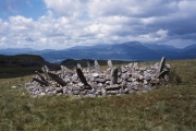
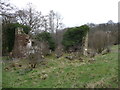
Iron Age and Later PrehistorySite Name: Bryn Alyn Alternative Name: Caer Alyn Project
Country: Wales County: Wrexham Type: Hillfort
Nearest Town: Wrexham  Nearest Village: Gwersyllt
Map Ref: SJ33125370  Landranger Map Number: 117
Latitude: 53.076322N  Longitude: 2.999765W
Condition:
5Perfect
4Almost Perfect
3Reasonable but with some damage
2Ruined but still recognisable as an ancient site
1Pretty much destroyed, possibly visible as crop marks
0No data.
-1Completely destroyed
4 Ambience:
5Superb
4Good
3Ordinary
2Not Good
1Awful
0No data.
3 Access:
5Can be driven to, probably with disabled access
4Short walk on a footpath
3Requiring a bit more of a walk
2A long walk
1In the middle of nowhere, a nightmare to find
0No data.
4 Accuracy:
5co-ordinates taken by GPS or official recorded co-ordinates
4co-ordinates scaled from a detailed map
3co-ordinates scaled from a bad map
2co-ordinates of the nearest village
1co-ordinates of the nearest town
0no data
5

Internal Links:
External Links:

I have visited· I would like to visit

beverlyanddavid visited on 16th Apr 2011 - their rating: Cond: 4 Amb: 4 Beverly and I are volunteer excavators at the site and are there most Saturdays. If you want to see the hill fort and our excavations just pop into Alyn Lodge most Saturdays and we will gladly show you our wonderful site.

Bryn Alyn
Bryn Alyn submitted by dodomad : The southern end of the Caer Alyn hillfort. The green circle marks the southern enclosure, the area excavated in 2010. The brown circle indicates the position of the second trench, over the linear feature. Image Credit: Natural Resources Wales, with annotations by Alan Brown (Vote or comment on this photo)
Hillfort in Wrexham. This site is being investigated as part of the Caer Alyn community archaeology Project. Image: The southern end of the Caer Alyn hillfort. The green circle marks the southern enclosure, the area excavated in 2010. The brown circle indicates the position of the second trench, over the linear feature. Credit: Natural Resources Wales, with annotations by Alan Brown

Their web site contains lots of information on the site, including dig diaries and photos.

2010 update: Summer school, Geophysical Survey, GIS project, possible neolithic burial chamber, and photo of the rock art found at Bryn Alyn, see the comments below for more.

Note: Caer Alyn: Wat’s Going On? A presentation by Alan Brown from Saturday's Special Offa online conference. You can still read and watch the presentations from the Offa’s Dyke Collanboratory blog
You may be viewing yesterday's version of this page. To see the most up to date information please register for a free account.


Bryn Alyn
Bryn Alyn submitted by dodomad : Reconstructed roundhouse 2. The CaerAlyn Archaeology project is looking for volunteers to help replace the roof. Source: https://twitter.com/caeralyn/media (Vote or comment on this photo)

Bryn Alyn
Bryn Alyn submitted by dodomad : The path down from Caer Alyn’s southern entrance, with a possible section of bank on the right side of the picture. Photo Credit: Alan Brown (Vote or comment on this photo)

Do not use the above information on other web sites or publications without permission of the contributor.

coldrum has found this location on Google Street View:

Nearby Images from Geograph Britain and Ireland:
SJ3353 : Car under trees near Wilderness Mill Farm, Wrexham by Jeremy Bolwell
by Jeremy Bolwell
©2012(licence)
SJ3353 : Part of Wilderness Mill Farm near Wrexham by Jeremy Bolwell
by Jeremy Bolwell
©2012(licence)
SJ3353 : Footbridge over the River Alyn / Afon Alun by Jeremy Bolwell
by Jeremy Bolwell
©2012(licence)
SJ3353 : Ruined building above the River Alyn / Afon Alun near Gwersyllt by Jeremy Bolwell
by Jeremy Bolwell
©2012(licence)
SJ3353 : Ruined building above the River Alyn / Afon Alun near Bradley by Jeremy Bolwell
by Jeremy Bolwell
©2012(licence)

The above images may not be of the site on this page, they are loaded from Geograph.
Please Submit an Image of this site or go out and take one for us!


Click here to see more info for this site

Nearby sites

Click here to view sites on an interactive OS map

Key: Red: member's photo, Blue: 3rd party photo, Yellow: other image, Green: no photo - please go there and take one, Grey: site destroyed

Download sites to:
KML (Google Earth)
GPX (GPS waypoints)
CSV (Garmin/Navman)
CSV (Excel)

To unlock full downloads you need to sign up as a Contributory Member. Otherwise downloads are limited to 50 sites.


Turn off the page maps and other distractions

Nearby sites listing. In the following links * = Image available
 2.0km NE 49° The Atropos Altar Stone* Sculptured Stone (SJ34645497)
 2.1km SE 142° Wrexham Gorsedd Circle Modern Stone Circle etc (SJ3436752064)
 2.6km W 261° Bryn Y Gaer Hillfort and St Paul's Church Hillfort (SJ30585334)
 3.0km ESE 114° Borras Quarry Neolithic Village Ancient Village or Settlement (SJ35855243)
 3.2km S 178° Wrexham County Borough Museum* Museum (SJ3318950455)
 3.6km NW 304° Plas Maen Stone* Rock Art (SJ3015555755)
 3.7km NW 318° Siambr Gladdu Abermorddu* Cairn (SJ30695648)
 4.1km NNW 334° Caer Estyn* Hillfort (SJ314574)
 4.1km S 179° Fairy Oak* Round Barrow(s) (SJ33144962)
 4.3km S 175° Hillbury* Round Barrow(s) (SJ33424939)
 5.2km NNW 335° Hope Church Early Medieval Stones* Ancient Cross (SJ310584)
 5.5km NE 40° St Peter's Well (Denbighshire) Holy Well or Sacred Spring (SJ36735784)
 5.9km NNW 329° Park in the Past* Museum (SJ301588)
 6.1km SSW 203° Croes-Foel* Round Barrow(s) (SJ307481)
 6.4km SSW 199° Hafod-y-bwch* Round Barrow(s) (SJ309477)
 6.4km WSW 256° Minera Cup Stone* Rock Art (SJ26875225)
 8.2km ENE 72° Knowl Plantation Barrow Cemetery (SJ410561)
 8.2km ENE 74° Churton* Long Barrow (SJ411558)
 8.6km NE 56° Poulton Timber Circle* Ancient Village or Settlement (SJ4033558472)
 8.7km SSE 154° Gerwyn Fechan Cursus (SJ36884584)
 9.4km WNW 299° Carreg-y-Llech* Standing Stone (Menhir) (SJ24875835)
 9.7km WNW 296° Bryntirion Round Barrows* Round Barrow(s) (SJ2445058160)
 9.8km WNW 294° Pen Y Stryt Barrow* Round Barrow(s) (SJ2423057830)
 9.8km WNW 292° Pentre Round Barrow* Round Barrow(s) (SJ2401057440)
 9.9km W 263° Maes Maelor* Barrow Cemetery (SJ23275255)
View more nearby sites and additional images

<< Tambo Colorado

Cairn Mude >>

Please add your thoughts on this site

Prehistoric houses at Sumburgh in Shetland

Prehistoric houses at Sumburgh in Shetland

Sponsors

Auto-Translation (Google)

Translate from English into:

"Bryn Alyn" | Login/Create an Account | 16 News and Comments
  
Go back to top of page    Comments are owned by the poster. We aren't responsible for their content.
Special Offa 9: Caer Alyn: Wat’s Going On? – Alan Brown by Andy B on Saturday, 04 April 2020
(User Info | Send a Message)
The Caer Alyn Project is situated on the edge of the village of Llay, 3.8km north of Wrexham. The core area of the project is a plateau of land surrounded on three sides by the River Alyn. This area includes an Iron Age inland promontory fort known as Caer Alyn (or Bryn Alyn Camp), which lies at the southern tip of the plateau, within a hairpin bend in the River Alyn

Sections of Wat’s Dyke have been located both to the north and south of the plateau and the most direct course between these points would be along the western edge of the Caer Alyn plateau and the fort.

There is possible evidence for the dyke at the southern end of the fort, where a depression leading up from the valley appears to be an entrance point into the fort. On the western side of this depression is a small bank and on the western side of that, facing into Wales, is what appears to be a shallow ditch.

This bank and ditch would seem to serve no defensive purpose, as immediately beyond them there is a very steep drop down into the Alyn valley. They might, though, be a section of Wat’s Dyke. However, this bank and ditch are within the fort’s scheduled area, so currently we cannot investigate them.

However, the western edge of the Caer Alyn plateau to the north of the fort is unscheduled and no archaeological investigation has ever been undertaken on any part of it. We had intended to excavate a section of this area in August 2020 but due to the Covid-19 outbreak we may need to postpone this investigation.

In 2006 a geophysical survey was carried out in the area just north of the fort. Fourteen 20m grids were surveyed (Fig 4). The plot is complicated and includes a football pitch in the top left corner. The banks and ditches of the fort (presumed to be Iron Age) are situated just outside the survey area, to the south. The most outstanding anomalies in the survey are the semi-circular ditches running from east to west in the lower section of the plot. The biggest and deepest ditch is the northern one. This ditch seems to cross a linear feature (marked by the yellow line) on the western edge of the plateau: this is the assumed path of Wat’s Dyke. The plan is to put a trench in the area where both features cross, as indicated by the orange circle, with the aim being to ascertain if the linear feature is associated with the large cross ditch and/or with Wat’s Dyke. If this linear feature is associated with the dyke, it may also be possible to obtain dating evidence from it. The two cross ditches may indicate that the fort’s northern defences were reinforced at some point, possibly during the construction of the dyke or after its construction if the fort was being used as a defensible control point on the dyke.

Read More at
https://offaswatsdyke.wordpress.com/2020/04/04/special-offa-9-caer-alyn-wats-going-on-alan-brown/
[ Reply to This ]

Re: Bryn Alyn by Anne T on Monday, 14 August 2017
(User Info | Send a Message)
For more information see Coflein NPRN 94754 which says: "Bryn Alyn Camp is an elongated enclosure, c.178m fron north to south by 62m, set upon the summit of a promontory all but surrounded by a deep meander of the River Alun. It partly incorporates, and makes use of in its own defences, Wat's Dyke (NPRN 91938). It is defined on the north by three banks and an outer ditch, and by double ramparts facing east. The west side rests on steep slopes above the river. There is a south facing entrance. Aerial photographs show a further banked oval enclosure springing from the south-east of Bryn Alyn, c.120m from northwest to south-east by 100m, occupying the nab-end of the promontory."
[ Reply to This ]

Caer Alyn Project on Twitter by Andy B on Tuesday, 02 May 2017
(User Info | Send a Message)
The Caer Alyn Project has its own Twitter page here.
https://twitter.com/caeralyn

They are working on rebuilding their web site at the moment and hope to share more information about their recent work on it. [It looks like someone forgot to renew their Caeralyn domain name as it's been taken over by the Chinese!]
[ Reply to This ]

Caer in the Community: the Caer Alyn Project by Andy B on Tuesday, 02 May 2017
(User Info | Send a Message)
Bryn Alyn Camp/Caer Alyn hillfort occupies a striking and strategic location in regards to movement through the landscape from prehistory to recent times. It is located on a striking defensible promontory overlooking a very tight bend in the River Alyn at the point where it dramatically changes its southerly course to bend a full 180 degrees to flow northwards.

The significance of this location cannot be underestimated. More at
https://howardwilliamsblog.wordpress.com/2016/02/24/caer-in-the-community-the-caer-alyn-project/
[ Reply to This ]

Caer Alyn @ Home, Wrexham, Sat 27th July by Andy B on Friday, 19 July 2013
(User Info | Send a Message)
The Caer Alyn @ Home event welcomes visitors to our project to experience the work of the local community archaeologists working at an Iron Age site near Wrexham. Come along and get your hands dirty, have a look at the work being carried out on the site, or just take one of the tours around the site. For the young archaeologists our CAYA group will explain how the young people can get involved in the project. Car parking and light refreshments available on the day. Caer Alyn Gartref

Mae’r digwyddiad Caer Alyn Gartref yn croesawu ymwelwyr i’n prosiect i brofi gwaith archeolegwyr y gymuned leol sy’n gweithio ar safle o’r Oes Haearn ger Wrecsam. Dewch i ymuno a baeddu’ch dwylo, neu gael golwg ar y gwaith sy’n digwydd ar y safle, neu gallwch fynd ar un o’r teithiau o gwmpas y safle. Ar gyfer yr archeolegwyr ifanc bydd ein grŵp CAYA yn egluro sut y gall pobl ifanc ddod yn rhan o’r prosiect. Bydd meysydd parcio a lluniaeth ysgafn ar gael ar y diwrnod.

Does dim angen archebu ymlaen llaw
Mae’r digwyddiad yma’n rhad ac am ddim

Organiser: Caer Alyn Archaeological Project
You do not need to book this event
This event is free to attend

Dates and times
Sat 27th Jul 2013 10:30-17:00 — Fri 26th Jul 2013 10:30-17:00

Pont y Capel Lane
Llay
Wrexham
LL12 8SA

Tel: 07947 768446
Email: fillcox@yahoo.co.uk
Web: http://www.caeralyn.org/community-archaeology.php

Part of the Festival of British Archaeology 2013
[ Reply to This ]

Bryn Alyn GIS Mapping Project Launched by Andy B on Saturday, 10 July 2010
(User Info | Send a Message)
GIS Mapping Project Launched

The new joint project between the Caer Alyn Project and Holt Local History Society is officially launched this Saturday. The project will use advanced mapping software to open up new research, and reveal two landscapes previously lost to time.

http://www.caeralyn.org/community-archaeology.php?refID=&content=story&storyID=250&fixedmetadataID=
[ Reply to This ]

Report on the Geophysical Survey at Bryn Alyn Fort by Andy B on Saturday, 10 July 2010
(User Info | Send a Message)
As part of the Caer Alyn Archaeological and Heritage Project, Dr Meggen Gondek of the University of Chester was asked to conduct gradiometer surveys within the interior of the hillfort at Bryn Alyn and also in an area to the south of the fort thought to contain a southern enclosure or annexe to the hillfort. Results suggest features within the hillfort interior possibly associated with burning (e.g. hearths) and structures or enclosures. Results from the southern enclosure show the enclosure ditch and potential features within the interior, possibly structural.

http://www.caeralyn.org/free_files/file1Report%20on%20the%20Geophysical%20Survey%20at%20Bryn%20Alyn%20Fort%201.doc
[ Reply to This ]

Caer Alyn Summer School 2010 by Andy B on Saturday, 10 July 2010
(User Info | Send a Message)
CAER ALYN ARCHAEOLOGICAL PROJECT - Wrexham
SUMMER DIG 2010
DATES: 7th August – 21st August 2010

Join the Caer Alyn team in excavating a potential prehistoric enclosure at the southern entrance to the Bryn Alyn hillfort

In 2008, Dr Meggen Gondek, University of Chester, completed a geophysical survey of the interior of the hillfort and an area just outside the southern entrance to the Bryn Hill fort, the results of which indicated that there are possible features in both areas. The objective of the 2010 season is to determine the location, survival, condition, function and date of any structures in the southern enclosure of the hillfort. The results of this excavation will provide the project with new information of the site, building on our previous investigations into the landscape of Caer Alyn.

Summer Dig details

The summer dig is open to all, from university students to private individuals who wish to experience hands on archaeology in the field.

Course fees: £60 for two weeks
Deposit: £25.00

Camping is available on site.(5mins from excavations) Cost £5.00 per night, breakfast extra. Full facilities are available at the site.

Summer dig training content:

The course has been designed as an introduction to Excavation Techniques, Archaeological Planning, Context Recording, Photography, Finds Processing, Surveying Techniques and Geophysical Surveying.

The Caer Alyn Project will supply all tools and equipment, plus all onsite facilities during the course. Participants are to bring their own waterproofs; digging clothes, work boots. Participants will be fully insured during the Summer Dig.

Please register online at http://www.caeralyn.org/community-archaeology.php?refID=&content=bespoke&bespokecontent=summerschool

If you require further information please email:
Phil Cox – Project Archaeologist fillcox@yahoo.co.uk
or call on 07958 937639.
[ Reply to This ]

Caer Alyn Rock Art by Andy B on Saturday, 10 July 2010
(User Info | Send a Message)
There is a photo of the rock art on page 6 of this PDF report
http://www.caeralyn.org/free_files/filetrench%2014%20update%20november%202009.pdf

What still remains hidden under the roots of the tree is the boulder which has
three cup marks finely pecked into the surface of the boulder. This rare example
of “rock art” was a significant find and has implications for the chamber structure,
the retaining wall and the trench as a whole. The rock art is dated to early
bronze age (or even earlier) and was either used as a building stone for the
structure (therefore the rock art was there by coincidence only) or deliberately
placed there. Both these possibilities have implications.

Regarding the rock art, if it was deliberately placed in the retaining wall feature at
its junction with the chamber, then that would suggest that the retaining wall and
chamber are contemporary with the rock art and therefore bronze-age or earlier!.
If it is just a re-used stone that has “rock art” on it, then, as all the stone in the
trench appears to be local, then we have a rock art panel local, which gives us a
bronze age or earlier local landscape. Either way, the “Rock Art” find is
important. There is no other recorded “rock Art” in North East Wales.

(but see http://www.megalithic.co.uk/article.php?sid=26601 meaning that last statement may need to be updated)


[ Reply to This ]

Re:Caer Alyn by coldrum on Wednesday, 28 April 2010
(User Info | Send a Message)
Street View


View Larger Map
[ Reply to This ]

Archaeological dig uncovers the past in Llay by Andy B on Friday, 16 April 2010
(User Info | Send a Message)
Since 2002, archaeologists and local enthusiasts have been digging at the site of an Iron Age hillfort in Llay, Wrexham

Take a walk on the banks of the River Alyn from Bradley to Llay, what we call today the Caer Alyn project area, and you will see few glimpses of its former glory.

Gone are the Iron Age people who built the Caer Alyn hillfort and Watts Dyke, and gone are the wheels that drove Medieval mill machines. Today, we're using the landscape to tell the story of the past.

The Caer Alyn project started with just one test pit as part of the Channel 4 TV programme, Time Team's Big Dig in 2002. Since then the Caer Alyn community archaeological heritage project has gone from strength to strength.

Excavations at the site over the last two years have recovered artefacts and other evidence that have opened up the medieval history of the site.

Also discovered on site has been Bronze Age rock art - the only example recorded in north east Wales to date.

The stone has been deliberately placed in the retaining wall feature at the entrance to dry stonewall chamber of unknown date.

Perhaps the most evocative find to date is a small hand brush about 15cm (5.9in] in length. This little brush was recovered from a late medieval context. What it was used for is still being debated.

The work of the volunteers during 2009 continued to open up new pages of Caer Alyn's history, from a small medieval industrial workshop and associated enclosure, located on the plateau above the River Alyn, to a possible prehistoric enclosure below the Bryn Alyn hillfort.

There are currently 35 volunteers working at Caer Alyn, undertaking different aspects of archaeology, from surveying to research. More volunteers are welcome to join.

For further details visit http://www.caeralyn.org
and
http://news.bbc.co.uk/local/northeastwales/hi/people_and_places/history/newsid_8471000/8471868.stm
[ Reply to This ]

Re: Bryn Alyn by Anonymous on Wednesday, 08 July 2009
Bryn Alyn is located in the village of Llay, therefore Llay is the nearest village!
[ Reply to This ]

Re: Bryn Alyn by Anonymous on Monday, 16 August 2004
The Bryn Alyn Hill Fort is now part of the investigation being carried out by the Caer Alyn Archaeological Research Project (CAARP). The hill fort is on private land and access is by appointment only. The CARRP web page will be available soon. The hill fort is a scheduled site and is part of a CADW management plan for conservation and protection.

It will be possible to make appointments via the web site when it becomes available.
I will post the URL on the comments page as soon as possible.

Alan Brown (CAARP)
[ Reply to This ]
    Re: Bryn Alyn by Anonymous on Monday, 14 March 2005
    The Web page for the Caer Alyn archaeological research project is
    at: http://srs.dl.ac.uk/arch/caeralyn/index.shtml
    [ Reply to This ]
    Re: Bryn Alyn by Anonymous on Monday, 13 June 2005
    The Caer Alyn Archaeological Research Project (CAARP) is holding an open day
    as part of national archaeology week entry is free. The site director will be
    giving guided tours of the site. There will be a display of archaeological field techniques. Visitors will get a chance to get there hands dirty.

    Date 23rd July (10am till 5pm)

    CAARP is located at, Alyn Lodge, Pont y Capel Lane, Llay, near Wrexham
    [ Reply to This ]
    Re: Bryn Alyn by Anonymous on Thursday, 15 February 2007
    New web site for the Caer Alyn project is
    http://www.caeralyn.org
    [ Reply to This ]

Your Name: Anonymous [ Register Now ]
Subject:


Add your comment or contribution to this page. Spam or offensive posts are deleted immediately, don't even bother

<<< What is five plus one as a number? (Please type the answer to this question in the little box on the left)
You can also embed videos and other things. For Youtube please copy and paste the 'embed code'.
For Google Street View please include Street View in the text.
Create a web link like this: <a href="https://www.megalithic.co.uk">This is a link</a>  

Allowed HTML is:
<p> <b> <i> <a> <img> <em> <br> <strong> <blockquote> <tt> <li> <ol> <ul> <object> <param> <embed> <iframe>

We would like to know more about this location. Please feel free to add a brief description and any relevant information in your own language.
Wir möchten mehr über diese Stätte erfahren. Bitte zögern Sie nicht, eine kurze Beschreibung und relevante Informationen in Deutsch hinzuzufügen.
Nous aimerions en savoir encore un peu sur les lieux. S'il vous plaît n'hesitez pas à ajouter une courte description et tous les renseignements pertinents dans votre propre langue.
Quisieramos informarnos un poco más de las lugares. No dude en añadir una breve descripción y otros datos relevantes en su propio idioma.