<< Our Photo Pages >> Clasach Cove - Class I Pictish Symbol Stone in Scotland in Moray
Submitted by alligator on Monday, 24 March 2003 Page Views: 9362
Early Medieval (Dark Age)Site Name: Clasach CoveCountry: Scotland County: Moray Type: Class I Pictish Symbol Stone
Map Ref: NJ16007013 Landranger Map Number: 28
Latitude: 57.713076N Longitude: 3.411523W
Condition:
| 5 | Perfect |
| 4 | Almost Perfect |
| 3 | Reasonable but with some damage |
| 2 | Ruined but still recognisable as an ancient site |
| 1 | Pretty much destroyed, possibly visible as crop marks |
| 0 | No data. |
| -1 | Completely destroyed |
| 5 | Superb |
| 4 | Good |
| 3 | Ordinary |
| 2 | Not Good |
| 1 | Awful |
| 0 | No data. |
| 5 | Can be driven to, probably with disabled access |
| 4 | Short walk on a footpath |
| 3 | Requiring a bit more of a walk |
| 2 | A long walk |
| 1 | In the middle of nowhere, a nightmare to find |
| 0 | No data. |
| 5 | co-ordinates taken by GPS or official recorded co-ordinates |
| 4 | co-ordinates scaled from a detailed map |
| 3 | co-ordinates scaled from a bad map |
| 2 | co-ordinates of the nearest village |
| 1 | co-ordinates of the nearest town |
| 0 | no data |
Be the first person to rate this site - see the 'Contribute!' box in the right hand menu.
Internal Links:
External Links:
")
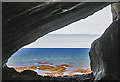
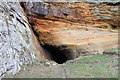
The small depiction of a Crescent and V-rod, on the top of the east wall of the cave at Clashach Cove. (A pale shadow compared to the grandeur of the nearby Sculptor's Cave).
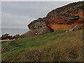
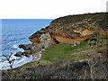
At Clashach Cove, the Eastern edge has a large cave, but it is the small tunnel to the West that houses the symbol, on it's Eastern wall.
For details, visit: http://www.archaeoptics.co.uk/products/ecms/367.html
You may be viewing yesterday's version of this page. To see the most up to date information please register for a free account.
")
Do not use the above information on other web sites or publications without permission of the contributor.
Nearby Images from Geograph Britain and Ireland:
©2020(licence)
©2013(licence)
©2020(licence)
©2013(licence)
©2014(licence)
The above images may not be of the site on this page, they are loaded from Geograph.
Please Submit an Image of this site or go out and take one for us!
Click here to see more info for this site
Nearby sites
Key: Red: member's photo, Blue: 3rd party photo, Yellow: other image, Green: no photo - please go there and take one, Grey: site destroyed
Download sites to:
KML (Google Earth)
GPX (GPS waypoints)
CSV (Garmin/Navman)
CSV (Excel)
To unlock full downloads you need to sign up as a Contributory Member. Otherwise downloads are limited to 50 sites.
Turn off the page maps and other distractions
Nearby sites listing. In the following links * = Image available
1.5km SSW 202° Inverugie* Round Cairn (NJ154687)
1.6km ENE 68° Sculptor's Cave* Class I Pictish Symbol Stone (NJ175707)
1.9km SSW 201° Camus Stone* Standing Stone (Menhir) (NJ15306840)
1.9km SSW 201° Inverugie Cup marked stone* Rock Art (NJ15296838)
2.3km SSW 211° Inverugie Souterrain* Souterrain (Fogou, Earth House) (NJ148682)
2.3km SSW 213° Inverugie Cup and Ring Marked rocks* Rock Art (NJ147682)
2.7km ESE 116° Gordounstoun Class II Pictish Symbol Stone (NJ184689)
3.2km SSW 207° Tappoch of Roseisle Round Cairn (NJ145673)
3.5km ESE 109° Gordonstoun Ogston Cross* Ancient Cross (NJ19276892)
4.1km WSW 254° St Ethan's Well (Burghead) Holy Well or Sacred Spring (NJ12076906)
5.1km WSW 258° Burghead 8 Class III Pictish Cross Slab (NJ11026915)
5.2km WSW 258° Burghead Holy Well* Holy Well or Sacred Spring (NJ109692)
5.2km WSW 257° Burghead Pictish Symbol Stones (class I) and Pictish Fort* Class I Pictish Symbol Stone (NJ109691)
5.2km WSW 258° Burghead* Hillfort (NJ10826918)
5.3km WSW 258° Burghead 5 and 9 Class III Pictish Cross Slab (NJ108691)
5.7km SSW 195° Easterton of Roseisle* Class I Pictish Symbol Stone (NJ144647)
6.3km E 95° Drainie 3, 13, 26 Class III Pictish Cross Slab (NJ223694)
7.3km S 177° Alves Stone Circle* Stone Circle (NJ162628)
7.4km SSE 159° Quarry Wood* Henge (NJ185631)
9.3km SE 141° Elgin Museum* Museum (NJ218628)
9.4km SE 138° Elgin symbol stone* Class II Pictish Symbol Stone (NJ2219263057)
11.8km ESE 117° Urquart Stones* Stone Circle (NJ26456450)
12.3km SSE 157° Birnie Pictish Stone* Class I Pictish Symbol Stone (NJ20645872)
12.6km SSE 156° Birnie Roundhouses* Misc. Earthwork (NJ210585)
12.8km SSE 167° Upper Manbeen* Class I Pictish Symbol Stone (NJ1868957615)
View more nearby sites and additional images


 We would like to know more about this location. Please feel free to add a brief description and any relevant information in your own language.
 Wir möchten mehr über diese Stätte erfahren. Bitte zögern Sie nicht, eine kurze Beschreibung und relevante Informationen in Deutsch hinzuzufügen.
 Nous aimerions en savoir encore un peu sur les lieux. S'il vous plaît n'hesitez pas à ajouter une courte description et tous les renseignements pertinents dans votre propre langue.
 Quisieramos informarnos un poco más de las lugares. No dude en añadir una breve descripción y otros datos relevantes en su propio idioma.