<< Our Photo Pages >> Urquart Stones - Stone Circle in Scotland in Moray
Submitted by lenny on Wednesday, 11 August 2004 Page Views: 10131
Neolithic and Bronze AgeSite Name: Urquart Stones Alternative Name: CappieshillCountry: Scotland County: Moray Type: Stone Circle
Nearest Town: Elgin Nearest Village: Urquart
Map Ref: NJ26456450
Latitude: 57.664351N Longitude: 3.234459W
Condition:
| 5 | Perfect |
| 4 | Almost Perfect |
| 3 | Reasonable but with some damage |
| 2 | Ruined but still recognisable as an ancient site |
| 1 | Pretty much destroyed, possibly visible as crop marks |
| 0 | No data. |
| -1 | Completely destroyed |
| 5 | Superb |
| 4 | Good |
| 3 | Ordinary |
| 2 | Not Good |
| 1 | Awful |
| 0 | No data. |
| 5 | Can be driven to, probably with disabled access |
| 4 | Short walk on a footpath |
| 3 | Requiring a bit more of a walk |
| 2 | A long walk |
| 1 | In the middle of nowhere, a nightmare to find |
| 0 | No data. |
| 5 | co-ordinates taken by GPS or official recorded co-ordinates |
| 4 | co-ordinates scaled from a detailed map |
| 3 | co-ordinates scaled from a bad map |
| 2 | co-ordinates of the nearest village |
| 1 | co-ordinates of the nearest town |
| 0 | no data |
Internal Links:
External Links:
")
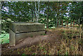
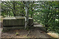
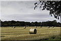
A stone circle on a cross roads about a mile from the village of Urquart.
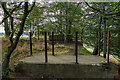
Easily seen from the road, access is through a gap in the fence. Three stones remain upright, two local pink granite stones from the Cairngorms the other is made of sandstone that is naturally pitted. They stand approx 1.5 m tall. Two more are fallen but can be found if you hunt through the undergrowth. The whole site is on a plateau with views through to the Cairngorms. 200m from this site is what is locally known as the witches hill, a very large man made object that stands over 25 ft. high. Documents from the begining of the 20 century indicate that once a stone circle stood atop the mound. The stones have all been robbed to make a local building, whilst part of the NW side has been dug away. The RCHMS files say that although not proven it is a strong candidate for a cairn, if it is you could fit a large town into it, apart from Silbury hill it one of the most massive man made hills I have ever seen. It is well worth a visit.
You may be viewing yesterday's version of this page. To see the most up to date information please register for a free account.
Do not use the above information on other web sites or publications without permission of the contributor.
coldrum has found this location on Google Street View:
Nearby Images from Geograph Britain and Ireland:
©2018(licence)
©2018(licence)
©2018(licence)
©2005(licence)
©2013(licence)
The above images may not be of the site on this page, they are loaded from Geograph.
Please Submit an Image of this site or go out and take one for us!
Click here to see more info for this site
Nearby sites
Key: Red: member's photo, Blue: 3rd party photo, Yellow: other image, Green: no photo - please go there and take one, Grey: site destroyed
Download sites to:
KML (Google Earth)
GPX (GPS waypoints)
CSV (Garmin/Navman)
CSV (Excel)
To unlock full downloads you need to sign up as a Contributory Member. Otherwise downloads are limited to 50 sites.
Turn off the page maps and other distractions
Nearby sites listing. In the following links * = Image available
2.5km E 99° Innesmill* Stone Circle (NJ28956407)
3.8km ENE 76° Binn Hill* Round Cairn (NJ30166532)
3.9km SSE 164° Bogton Mill* Stone Circle (NJ2743060765)
4.5km WSW 250° Elgin symbol stone* Class II Pictish Symbol Stone (NJ2219263057)
4.7km S 173° Errol circle Stone Circle (NJ26905984)
4.9km WSW 249° Elgin Museum* Museum (NJ218628)
6.4km NW 319° Drainie 3, 13, 26 Class III Pictish Cross Slab (NJ223694)
7.4km E 87° Browland* Stone Circle (NJ339647)
8.0km W 259° Quarry Wood* Henge (NJ185631)
8.1km SW 221° Birnie Roundhouses* Misc. Earthwork (NJ210585)
8.2km SW 224° Birnie Pictish Stone* Class I Pictish Symbol Stone (NJ20645872)
8.4km WNW 301° Gordonstoun Ogston Cross* Ancient Cross (NJ19276892)
9.1km WNW 298° Gordounstoun Class II Pictish Symbol Stone (NJ184689)
10.0km SSW 191° Netherglen* Standing Stone (Menhir) (NJ24315476)
10.4km SW 227° Upper Manbeen* Class I Pictish Symbol Stone (NJ1868957615)
10.4km W 260° Alves Stone Circle* Stone Circle (NJ162628)
10.7km E 96° Cowiemuir* Stone Circle (NJ37096310)
10.8km ESE 118° Bellie Round Barrow(s) (NJ359592)
10.9km WNW 304° Sculptor's Cave* Class I Pictish Symbol Stone (NJ175707)
11.0km SSE 147° St Mary's Well (Inchberry)* Holy Well or Sacred Spring (NJ323552)
11.8km WNW 288° Camus Stone* Standing Stone (Menhir) (NJ15306840)
11.8km WNW 288° Inverugie Cup marked stone* Rock Art (NJ15296838)
11.8km WNW 290° Inverugie* Round Cairn (NJ154687)
11.8km WNW 297° Clasach Cove* Class I Pictish Symbol Stone (NJ16007013)
12.0km W 270° Easterton of Roseisle* Class I Pictish Symbol Stone (NJ144647)
View more nearby sites and additional images


 We would like to know more about this location. Please feel free to add a brief description and any relevant information in your own language.
 Wir möchten mehr über diese Stätte erfahren. Bitte zögern Sie nicht, eine kurze Beschreibung und relevante Informationen in Deutsch hinzuzufügen.
 Nous aimerions en savoir encore un peu sur les lieux. S'il vous plaît n'hesitez pas à ajouter une courte description et tous les renseignements pertinents dans votre propre langue.
 Quisieramos informarnos un poco más de las lugares. No dude en añadir una breve descripción y otros datos relevantes en su propio idioma.