


<< Our Photo Pages >> Camus Stone - Standing Stone (Menhir) in Scotland in Moray
Submitted by Klingon on Saturday, 05 February 2005 Page Views: 10584
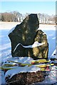
Neolithic and Bronze AgeSite Name: Camus StoneCountry: Scotland County: Moray Type: Standing Stone (Menhir)
Nearest Town: Lossiemouth Nearest Village: Duffus
Map Ref: NJ15306840
Latitude: 57.697410N Longitude: 3.422659W
Condition:
| 5 | Perfect |
| 4 | Almost Perfect |
| 3 | Reasonable but with some damage |
| 2 | Ruined but still recognisable as an ancient site |
| 1 | Pretty much destroyed, possibly visible as crop marks |
| 0 | No data. |
| -1 | Completely destroyed |
| 5 | Superb |
| 4 | Good |
| 3 | Ordinary |
| 2 | Not Good |
| 1 | Awful |
| 0 | No data. |
| 5 | Can be driven to, probably with disabled access |
| 4 | Short walk on a footpath |
| 3 | Requiring a bit more of a walk |
| 2 | A long walk |
| 1 | In the middle of nowhere, a nightmare to find |
| 0 | No data. |
| 5 | co-ordinates taken by GPS or official recorded co-ordinates |
| 4 | co-ordinates scaled from a detailed map |
| 3 | co-ordinates scaled from a bad map |
| 2 | co-ordinates of the nearest village |
| 1 | co-ordinates of the nearest town |
| 0 | no data |
Internal Links:
External Links:
I have visited· I would like to visit
Klingon visited - their rating: Cond: 4 Amb: 5 Access: 3
")
Has two fine rock art spirals at the northern side.
You may be viewing yesterday's version of this page. To see the most up to date information please register for a free account.
")
")
")
Do not use the above information on other web sites or publications without permission of the contributor.
Nearby Images from Geograph Britain and Ireland:
©2010(licence)
©2006(licence)
©2010(licence)
©2020(licence)
©2020(licence)
The above images may not be of the site on this page, they are loaded from Geograph.
Please Submit an Image of this site or go out and take one for us!
Click here to see more info for this site
Nearby sites
Key: Red: member's photo, Blue: 3rd party photo, Yellow: other image, Green: no photo - please go there and take one, Grey: site destroyed
Download sites to:
KML (Google Earth)
GPX (GPS waypoints)
CSV (Garmin/Navman)
CSV (Excel)
To unlock full downloads you need to sign up as a Contributory Member. Otherwise downloads are limited to 50 sites.
Turn off the page maps and other distractions
Nearby sites listing. In the following links * = Image available
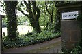
22m SSW 205° Inverugie Cup marked stone* Rock Art (NJ15296838)
316m NNE 17° Inverugie* Round Cairn (NJ154687)
537m WSW 247° Inverugie Souterrain* Souterrain (Fogou, Earth House) (NJ148682)
631m WSW 250° Inverugie Cup and Ring Marked rocks* Rock Art (NJ147682)
1.4km SW 215° Tappoch of Roseisle Round Cairn (NJ145673)
1.9km NNE 21° Clasach Cove* Class I Pictish Symbol Stone (NJ16007013)
3.1km E 80° Gordounstoun Class II Pictish Symbol Stone (NJ184689)
3.2km NE 42° Sculptor's Cave* Class I Pictish Symbol Stone (NJ175707)
3.3km W 280° St Ethan's Well (Burghead) Holy Well or Sacred Spring (NJ12076906)
3.8km SSW 192° Easterton of Roseisle* Class I Pictish Symbol Stone (NJ144647)
4.0km E 81° Gordonstoun Ogston Cross* Ancient Cross (NJ19276892)
4.3km W 279° Burghead 8 Class III Pictish Cross Slab (NJ11026915)
4.4km W 278° Burghead Pictish Symbol Stones (class I) and Pictish Fort* Class I Pictish Symbol Stone (NJ109691)
4.5km W 279° Burghead Holy Well* Holy Well or Sacred Spring (NJ109692)
4.5km W 279° Burghead* Hillfort (NJ10826918)
4.5km W 278° Burghead 5 and 9 Class III Pictish Cross Slab (NJ108691)
5.7km S 170° Alves Stone Circle* Stone Circle (NJ162628)
6.2km SSE 148° Quarry Wood* Henge (NJ185631)
7.0km E 81° Drainie 3, 13, 26 Class III Pictish Cross Slab (NJ223694)
8.6km SE 130° Elgin Museum* Museum (NJ218628)
8.7km SE 127° Elgin symbol stone* Class II Pictish Symbol Stone (NJ2219263057)
11.0km SSE 150° Birnie Pictish Stone* Class I Pictish Symbol Stone (NJ20645872)
11.3km SSE 161° Upper Manbeen* Class I Pictish Symbol Stone (NJ1868957615)
11.4km SSE 149° Birnie Roundhouses* Misc. Earthwork (NJ210585)
11.8km ESE 108° Urquart Stones* Stone Circle (NJ26456450)
View more nearby sites and additional images


 We would like to know more about this location. Please feel free to add a brief description and any relevant information in your own language.
 Wir möchten mehr über diese Stätte erfahren. Bitte zögern Sie nicht, eine kurze Beschreibung und relevante Informationen in Deutsch hinzuzufügen.
 Nous aimerions en savoir encore un peu sur les lieux. S'il vous plaît n'hesitez pas à ajouter une courte description et tous les renseignements pertinents dans votre propre langue.
 Quisieramos informarnos un poco más de las lugares. No dude en añadir una breve descripción y otros datos relevantes en su propio idioma.