

<< Our Photo Pages >> Dolmen du Buisson - Burial Chamber or Dolmen in France in Languedoc:Lozère (48)
Submitted by TheCaptain on Saturday, 16 April 2005 Page Views: 2873
Neolithic and Bronze AgeSite Name: Dolmen du Buisson Alternative Name: Lo Geïon, Chamblon, Pèira Giganta, Pèira dau Geïon,Country: France Département: Languedoc:Lozère (48) Type: Burial Chamber or Dolmen
Nearest Town: Mende Nearest Village: Mas-Saint-Chély
Latitude: 44.330434N Longitude: 3.426847E
Condition:
| 5 | Perfect |
| 4 | Almost Perfect |
| 3 | Reasonable but with some damage |
| 2 | Ruined but still recognisable as an ancient site |
| 1 | Pretty much destroyed, possibly visible as crop marks |
| 0 | No data. |
| -1 | Completely destroyed |
| 5 | Superb |
| 4 | Good |
| 3 | Ordinary |
| 2 | Not Good |
| 1 | Awful |
| 0 | No data. |
| 5 | Can be driven to, probably with disabled access |
| 4 | Short walk on a footpath |
| 3 | Requiring a bit more of a walk |
| 2 | A long walk |
| 1 | In the middle of nowhere, a nightmare to find |
| 0 | No data. |
| 5 | co-ordinates taken by GPS or official recorded co-ordinates |
| 4 | co-ordinates scaled from a detailed map |
| 3 | co-ordinates scaled from a bad map |
| 2 | co-ordinates of the nearest village |
| 1 | co-ordinates of the nearest town |
| 0 | no data |
Internal Links:
External Links:
I have visited· I would like to visit
DrewParsons would like to visit
johnstone visited on 26th Jul 1999 - their rating: Cond: 4 Amb: 4 Access: 4
")
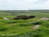
The thick capstone (about 3 x 2,5 m) is broken in 3 pieces.
Chamblon dolmen (also called Buisson dolmen). In the country, it is known as "la Pèira Giganta" or "Pèira dau Geïon"
Base Mérimée (Historic Monument)
You may be viewing yesterday's version of this page. To see the most up to date information please register for a free account.
")
")
Do not use the above information on other web sites or publications without permission of the contributor.
Click here to see more info for this site
Nearby sites
Click here to view sites on an interactive map of the areaKey: Red: member's photo, Blue: 3rd party photo, Yellow: other image, Green: no photo - please go there and take one, Grey: site destroyed
Download sites to:
KML (Google Earth)
GPX (GPS waypoints)
CSV (Garmin/Navman)
CSV (Excel)
To unlock full downloads you need to sign up as a Contributory Member. Otherwise downloads are limited to 50 sites.
Turn off the page maps and other distractions
Nearby sites listing. In the following links * = Image available
828m WSW 237° Dolmen de Petit Batailles Burial Chamber or Dolmen
941m S 173° Menhir des Espougnes* Standing Stone (Menhir)
2.1km SE 141° Dolmen de Vallongue* Burial Chamber or Dolmen
2.8km SW 231° Dolmen de la Marque* Burial Chamber or Dolmen
4.3km NNW 342° Fountain of Burle (Sainte Enimie) Holy Well or Sacred Spring
4.3km NNW 342° Dolmen de Téoulets Burial Chamber or Dolmen
4.8km SSE 157° Moures menhir Standing Stone (Menhir)
4.9km SW 231° Enciente de la Tourelle Ancient Village or Settlement
5.0km SSE 166° Menhir du Fraïsse* Standing Stone (Menhir)
5.1km NNE 25° Tumulus de Jouanas Cairn
5.8km NE 37° Tumulus des Lacs 4 Cairn
5.9km NE 37° Tumulus des Lacs 2 Cairn
5.9km NNW 349° Dolmen de Dignas* Burial Chamber or Dolmen
6.0km NE 36° Tumulus des Lacs 1 Cairn
6.1km SSE 150° Menhir de la plaine de Chanet* Standing Stone (Menhir)
6.1km NE 39° Tumulus des Lacs 3 Cairn
6.5km NW 309° Devez Dolmen Burial Chamber or Dolmen
7.0km NNE 15° Tumulus du Mont Roubio Cairn
7.2km NNW 329° Dolmen de la Baume (Sainte-Enimie)* Burial Chamber or Dolmen
7.4km N 352° Menhir du Bac* Standing Stone (Menhir)
7.4km S 189° Enceinte Protohistorique de la Rode* Ancient Village or Settlement
7.5km NNE 12° Dolmen de Peyrelevade (Sauveterre)* Burial Chamber or Dolmen
7.6km N 10° Tumulus de Chardounio Cairn
7.8km SSW 205° Dolmen des Avens Burial Chamber or Dolmen
8.0km E 88° Dolmen de Condamine Burial Chamber or Dolmen
View more nearby sites and additional images


 We would like to know more about this location. Please feel free to add a brief description and any relevant information in your own language.
 Wir möchten mehr über diese Stätte erfahren. Bitte zögern Sie nicht, eine kurze Beschreibung und relevante Informationen in Deutsch hinzuzufügen.
 Nous aimerions en savoir encore un peu sur les lieux. S'il vous plaît n'hesitez pas à ajouter une courte description et tous les renseignements pertinents dans votre propre langue.
 Quisieramos informarnos un poco más de las lugares. No dude en añadir una breve descripción y otros datos relevantes en su propio idioma.