<< Our Photo Pages >> Abri de Lartet - Cave or Rock Shelter in France in Aquitaine:Dordogne (24)
Submitted by TheCaptain on Saturday, 16 April 2005 Page Views: 5951
Natural PlacesSite Name: Abri de LartetCountry: France Département: Aquitaine:Dordogne (24) Type: Cave or Rock Shelter
Nearest Town: Sarlat-la-Canéda Nearest Village: Les-Eyzies
Latitude: 44.943700N Longitude: 0.997800E
Condition:
| 5 | Perfect |
| 4 | Almost Perfect |
| 3 | Reasonable but with some damage |
| 2 | Ruined but still recognisable as an ancient site |
| 1 | Pretty much destroyed, possibly visible as crop marks |
| 0 | No data. |
| -1 | Completely destroyed |
| 5 | Superb |
| 4 | Good |
| 3 | Ordinary |
| 2 | Not Good |
| 1 | Awful |
| 0 | No data. |
| 5 | Can be driven to, probably with disabled access |
| 4 | Short walk on a footpath |
| 3 | Requiring a bit more of a walk |
| 2 | A long walk |
| 1 | In the middle of nowhere, a nightmare to find |
| 0 | No data. |
| 5 | co-ordinates taken by GPS or official recorded co-ordinates |
| 4 | co-ordinates scaled from a detailed map |
| 3 | co-ordinates scaled from a bad map |
| 2 | co-ordinates of the nearest village |
| 1 | co-ordinates of the nearest town |
| 0 | no data |
Internal Links:
External Links:
I have visited· I would like to visit
TheCaptain visited on 19th May 2005 - their rating: Cond: 2 Amb: 3 Access: 4 This cliff shelter was discovered by Lartet in 1863 and is classed as a National Historic Monument. Its just a few metres up the valley side from its more famous neighbour Abri du Poisson.
")
You may be viewing yesterday's version of this page. To see the most up to date information please register for a free account.
Do not use the above information on other web sites or publications without permission of the contributor.
Nearby Images from Flickr


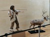
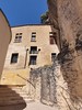
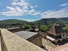
The above images may not be of the site on this page, but were taken nearby. They are loaded from Flickr so please click on them for image credits.
Click here to see more info for this site
Nearby sites
Click here to view sites on an interactive map of the areaKey: Red: member's photo, Blue: 3rd party photo, Yellow: other image, Green: no photo - please go there and take one, Grey: site destroyed
Download sites to:
KML (Google Earth)
GPX (GPS waypoints)
CSV (Garmin/Navman)
CSV (Excel)
To unlock full downloads you need to sign up as a Contributory Member. Otherwise downloads are limited to 50 sites.
Turn off the page maps and other distractions
Nearby sites listing. In the following links * = Image available
39m NE 55° Abri du Poisson* Cave or Rock Shelter
235m SE 130° Grotte de l'Oreille d'Enfer* Cave or Rock Shelter
590m N 2° Grotte de Grand Roc* Cave or Rock Shelter
672m N 3° Abri de Laugerie-Basse* Cave or Rock Shelter
991m ESE 110° Abri de Cro-Magnon* Cave or Rock Shelter
1.1km NNE 22° Abri de Laugerie-Haute* Cave or Rock Shelter
1.3km ESE 120° Gisement du Pataud* Cave or Rock Shelter
1.5km ESE 124° Musée National de Préhistoire* Museum
1.7km NNE 23° Gisement de la Micoque* Cave or Rock Shelter
1.9km SE 126° Grotte d'Abzac Cave or Rock Shelter
1.9km SE 126° Grotte de la Croze* Cave or Rock Shelter
2.6km ESE 111° Font-de-Gaume* Cave or Rock Shelter
2.8km SE 139° Grotte de la Mouthe* Cave or Rock Shelter
3.1km SW 231° Grotte du Sorcier* Cave or Rock Shelter
3.3km SSE 164° La Combe cave* Cave or Rock Shelter
3.5km E 89° Grotte des Combarelles II* Cave or Rock Shelter
3.5km E 90° Grotte des Combarelles 1* Cave or Rock Shelter
3.6km NE 42° Abri de la Madeleine* Cave or Rock Shelter
3.7km N 0° Peyrelevade de Fleurac* Burial Chamber or Dolmen
3.8km NE 43° Source de la Madeleine* Holy Well or Sacred Spring
3.9km NE 44° Village de la Madeleine* Ancient Village or Settlement
4.4km SSW 210° Grotte du Roc de Marsal* Cave or Rock Shelter
4.6km SSW 205° Campagne menhir* Standing Stone (Menhir)
4.8km W 281° Abri de la Ferrassie* Cave or Rock Shelter
5.1km E 93° Roc de Cazelle* Ancient Village or Settlement
View more nearby sites and additional images


 We would like to know more about this location. Please feel free to add a brief description and any relevant information in your own language.
 Wir möchten mehr über diese Stätte erfahren. Bitte zögern Sie nicht, eine kurze Beschreibung und relevante Informationen in Deutsch hinzuzufügen.
 Nous aimerions en savoir encore un peu sur les lieux. S'il vous plaît n'hesitez pas à ajouter une courte description et tous les renseignements pertinents dans votre propre langue.
 Quisieramos informarnos un poco más de las lugares. No dude en añadir una breve descripción y otros datos relevantes en su propio idioma.