

<< Our Photo Pages >> Torget - Standing Stone (Menhir) in Norway in Østfold
Submitted by kenntha88 on Friday, 05 November 2021 Page Views: 229
Iron Age and Later PrehistorySite Name: TorgetCountry: Norway Fylke: Østfold Type: Standing Stone (Menhir)
Nearest Town: Sarpsborg
Latitude: 59.293702N Longitude: 11.035211E
Condition:
| 5 | Perfect |
| 4 | Almost Perfect |
| 3 | Reasonable but with some damage |
| 2 | Ruined but still recognisable as an ancient site |
| 1 | Pretty much destroyed, possibly visible as crop marks |
| 0 | No data. |
| -1 | Completely destroyed |
| 5 | Superb |
| 4 | Good |
| 3 | Ordinary |
| 2 | Not Good |
| 1 | Awful |
| 0 | No data. |
| 5 | Can be driven to, probably with disabled access |
| 4 | Short walk on a footpath |
| 3 | Requiring a bit more of a walk |
| 2 | A long walk |
| 1 | In the middle of nowhere, a nightmare to find |
| 0 | No data. |
| 5 | co-ordinates taken by GPS or official recorded co-ordinates |
| 4 | co-ordinates scaled from a detailed map |
| 3 | co-ordinates scaled from a bad map |
| 2 | co-ordinates of the nearest village |
| 1 | co-ordinates of the nearest town |
| 0 | no data |
Internal Links:
External Links:
")
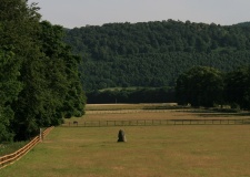
Not far away from the huge barrow cemetery at Opstad is a smaller barrow cemetery with some smaller barrows and a standing stone. The only monument I could find was the standing stone, the area is overgrown with larger trees and smaller brush and very tight vegetation, making the barrows almost invisible.
The barrows consists of four round and one triangular shaped barrow. They are from 8 to 10 metres in diameter but only around 50cm in height. The standing stones is believed to maybe belong to a long row of standing stones stretching from the four standing stones at the Opstad barrow cemetery and all the way westwards to the farm Visterflo.
The standing stone 1,3 metres in height, 70cm wide and 10cm thick. It narrows towards the top and ends in a sharp point, making the stone have an almost triangle shape.
You may be viewing yesterday's version of this page. To see the most up to date information please register for a free account.
")
")
")
Do not use the above information on other web sites or publications without permission of the contributor.
Nearby Images from Flickr


The above images may not be of the site on this page, but were taken nearby. They are loaded from Flickr so please click on them for image credits.
Click here to see more info for this site
Nearby sites
Click here to view sites on an interactive map of the areaKey: Red: member's photo, Blue: 3rd party photo, Yellow: other image, Green: no photo - please go there and take one, Grey: site destroyed
Download sites to:
KML (Google Earth)
GPX (GPS waypoints)
CSV (Garmin/Navman)
CSV (Excel)
To unlock full downloads you need to sign up as a Contributory Member. Otherwise downloads are limited to 50 sites.
Turn off the page maps and other distractions
Nearby sites listing. In the following links * = Image available
393m SSW 212° Visterflo Standing Stone Row* Stone Row / Alignment
489m ESE 114° Opstad barrow cemetery* Barrow Cemetery
527m SE 124° Opstadveien South* Round Barrow(s)
589m E 80° Opstadveien Ratoppen* Stone Circle
1.5km E 92° Villhageveien* Round Barrow(s)
1.5km NNE 22° Sandtangen* Barrow Cemetery
1.7km E 93° Tingstad Steinring* Stone Circle
1.8km E 92° Grålum* Round Barrow(s)
1.9km E 90° Tuneveien* Barrow Cemetery
2.2km E 88° Tune barrow cemetery* Stone Circle
2.3km E 88° Tingvollheimen* Barrow Cemetery
2.4km SW 228° Båthaugen Tuneskipet* Round Barrow(s)
2.5km NNE 14° Kalnes* Carving
2.9km E 94° Tune Runestone* Carving
3.1km ENE 67° Steinrødodden* Hillfort
3.1km E 92° Trompeterhøyden* Barrow Cemetery
3.7km W 262° Hødal Hillfort* Hillfort
4.0km SE 131° Utsikten-Alvim* Rock Art
4.5km ESE 108° Kulåsparken* Barrow Cemetery
4.8km NW 325° Sandbakken* Standing Stone (Menhir)
5.4km ENE 70° Herresal Bygdeborgen* Hillfort
5.4km SE 140° Årumsåsen* Rock Art
5.5km ENE 72° Jomfrusal Bygdeborgen* Hillfort
5.7km S 179° Lilleborge* Rock Art
5.8km SSW 203° Myråsveien* Rock Art
View more nearby sites and additional images


 We would like to know more about this location. Please feel free to add a brief description and any relevant information in your own language.
 Wir möchten mehr über diese Stätte erfahren. Bitte zögern Sie nicht, eine kurze Beschreibung und relevante Informationen in Deutsch hinzuzufügen.
 Nous aimerions en savoir encore un peu sur les lieux. S'il vous plaît n'hesitez pas à ajouter une courte description et tous les renseignements pertinents dans votre propre langue.
 Quisieramos informarnos un poco más de las lugares. No dude en añadir una breve descripción y otros datos relevantes en su propio idioma.