

<< Our Photo Pages >> Herresal Bygdeborgen - Hillfort in Norway in Østfold
Submitted by kenntha88 on Tuesday, 24 September 2019 Page Views: 534
Iron Age and Later PrehistorySite Name: Herresal BygdeborgenCountry: Norway Fylke: Østfold Type: Hillfort
Nearest Town: Sarpsborg
Latitude: 59.310123N Longitude: 11.124390E
Condition:
| 5 | Perfect |
| 4 | Almost Perfect |
| 3 | Reasonable but with some damage |
| 2 | Ruined but still recognisable as an ancient site |
| 1 | Pretty much destroyed, possibly visible as crop marks |
| 0 | No data. |
| -1 | Completely destroyed |
| 5 | Superb |
| 4 | Good |
| 3 | Ordinary |
| 2 | Not Good |
| 1 | Awful |
| 0 | No data. |
| 5 | Can be driven to, probably with disabled access |
| 4 | Short walk on a footpath |
| 3 | Requiring a bit more of a walk |
| 2 | A long walk |
| 1 | In the middle of nowhere, a nightmare to find |
| 0 | No data. |
| 5 | co-ordinates taken by GPS or official recorded co-ordinates |
| 4 | co-ordinates scaled from a detailed map |
| 3 | co-ordinates scaled from a bad map |
| 2 | co-ordinates of the nearest village |
| 1 | co-ordinates of the nearest town |
| 0 | no data |
Internal Links:
External Links:
")
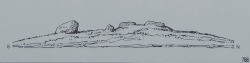
Herresal and Jomfrusal are almost like twin hill forts. They are located on two natural hilltops next to each other with a small valley cutting through between them where the local road is today. They are both very similar in shape of walls and could have been built at the same time but not clear yet since it has been no excavations on these hillforts. Since they are probably two different structures I have choosen to put them in two different sites.
You may be viewing yesterday's version of this page. To see the most up to date information please register for a free account.
")
")
")
")
")
")
")
")
")
")
")
Do not use the above information on other web sites or publications without permission of the contributor.
Click here to see more info for this site
Nearby sites
Click here to view sites on an interactive map of the areaKey: Red: member's photo, Blue: 3rd party photo, Yellow: other image, Green: no photo - please go there and take one, Grey: site destroyed
Download sites to:
KML (Google Earth)
GPX (GPS waypoints)
CSV (Garmin/Navman)
CSV (Excel)
To unlock full downloads you need to sign up as a Contributory Member. Otherwise downloads are limited to 50 sites.
Turn off the page maps and other distractions
Nearby sites listing. In the following links * = Image available
223m ESE 117° Jomfrusal Bygdeborgen* Hillfort
910m NNE 26° Maugesten* Barrow Cemetery
2.3km WSW 255° Steinrødodden* Hillfort
2.7km SW 225° Trompeterhøyden* Barrow Cemetery
3.0km SW 228° Tune Runestone* Carving
3.3km WSW 238° Tingvollheimen* Barrow Cemetery
3.3km SSW 193° Kulåsparken* Barrow Cemetery
3.4km WSW 239° Tune barrow cemetery* Stone Circle
3.7km WSW 240° Tuneveien* Barrow Cemetery
3.8km WSW 240° Grålum* Round Barrow(s)
3.9km WSW 241° Tingstad Steinring* Stone Circle
4.1km WSW 242° Villhageveien* Round Barrow(s)
4.4km S 173° Hafslundparken* Barrow Cemetery
4.5km W 278° Kalnes* Carving
4.5km W 264° Sandtangen* Barrow Cemetery
4.7km S 173° Hafslund helleristninger* Rock Art
4.8km WSW 249° Opstadveien Ratoppen* Stone Circle
4.9km SSW 204° Utsikten-Alvim* Rock Art
5.0km WSW 246° Opstad barrow cemetery* Barrow Cemetery
5.1km WSW 245° Opstadveien South* Round Barrow(s)
5.4km WSW 250° Torget* Standing Stone (Menhir)
5.6km SSE 163° Borgenveien* Rock Art
5.7km WSW 248° Visterflo Standing Stone Row* Stone Row / Alignment
6.2km SSW 195° Årumsåsen* Rock Art
7.0km S 182° Molteberghellene* Rock Art
View more nearby sites and additional images


 We would like to know more about this location. Please feel free to add a brief description and any relevant information in your own language.
 Wir möchten mehr über diese Stätte erfahren. Bitte zögern Sie nicht, eine kurze Beschreibung und relevante Informationen in Deutsch hinzuzufügen.
 Nous aimerions en savoir encore un peu sur les lieux. S'il vous plaît n'hesitez pas à ajouter une courte description et tous les renseignements pertinents dans votre propre langue.
 Quisieramos informarnos un poco más de las lugares. No dude en añadir una breve descripción y otros datos relevantes en su propio idioma.