<< Our Photo Pages >> Shaugh Moor South Cairn Circle - Cairn in England in Devon
Submitted by Anne T on Tuesday, 05 November 2019 Page Views: 942
Neolithic and Bronze AgeSite Name: Shaugh Moor South Cairn Circle Alternative Name: Grinsell Shaugh Prior 41; Turner Stone Cirlce G17Country: England County: Devon Type: Cairn
Nearest Town: Yelverton / Plymouth Nearest Village: Shaugh Prior
Map Ref: SX5541863425
Latitude: 50.452798N Longitude: 4.03798W
Condition:
| 5 | Perfect |
| 4 | Almost Perfect |
| 3 | Reasonable but with some damage |
| 2 | Ruined but still recognisable as an ancient site |
| 1 | Pretty much destroyed, possibly visible as crop marks |
| 0 | No data. |
| -1 | Completely destroyed |
| 5 | Superb |
| 4 | Good |
| 3 | Ordinary |
| 2 | Not Good |
| 1 | Awful |
| 0 | No data. |
| 5 | Can be driven to, probably with disabled access |
| 4 | Short walk on a footpath |
| 3 | Requiring a bit more of a walk |
| 2 | A long walk |
| 1 | In the middle of nowhere, a nightmare to find |
| 0 | No data. |
| 5 | co-ordinates taken by GPS or official recorded co-ordinates |
| 4 | co-ordinates scaled from a detailed map |
| 3 | co-ordinates scaled from a bad map |
| 2 | co-ordinates of the nearest village |
| 1 | co-ordinates of the nearest town |
| 0 | no data |
Be the first person to rate this site - see the 'Contribute!' box in the right hand menu.
Internal Links:
External Links:
I have visited· I would like to visit
Catrinm visited on 15th Sep 2024 - their rating: Amb: 1 Access: 4 The grid ref on the MP app map is incorrect and leads to gorse and bracken... the grid ref here is further north..
TheCaptain have visited here
")
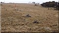
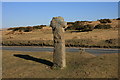
Information about this cairn comes from the Prehistoric Dartmoor Walks website - see their entry for the Shaugh Moor (S) Cairn Circle, which tells us this cairn circle is located at the southern end of the Shaugh Moor Stone row. It is described as an egg-shaped ring of stone uprights, with only four clearly identifiable stones left in the ring, which suggests a diameter of 15.0m.
The cairn is recorded as part of Pastscape Monument No. 439236, as MDV49564 (Retaining circle at south-western end of Shaugh Moor stone row), and scheduled as part of Historic England List ID 1002518 (Stone row NW of Saddlesborough).
For more information about the stone row and its associated cairns, see the Stone Rows of Great Britain's entry for the Shaugh Moor, which includes a plan of the monuments, photographs and links to online resources for more information.
Note: Have you visited this site? Do you have any photographs or information to add?
You may be viewing yesterday's version of this page. To see the most up to date information please register for a free account.
Do not use the above information on other web sites or publications without permission of the contributor.
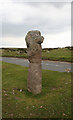
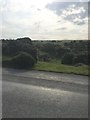
Nearby Images from Geograph Britain and Ireland:
©2020(licence)
©2019(licence)
©2020(licence)
©2010(licence)
©2020(licence)
The above images may not be of the site on this page, they are loaded from Geograph.
Please Submit an Image of this site or go out and take one for us!
Click here to see more info for this site
Nearby sites
Key: Red: member's photo, Blue: 3rd party photo, Yellow: other image, Green: no photo - please go there and take one, Grey: site destroyed
Download sites to:
KML (Google Earth)
GPX (GPS waypoints)
CSV (Garmin/Navman)
CSV (Excel)
To unlock full downloads you need to sign up as a Contributory Member. Otherwise downloads are limited to 50 sites.
Turn off the page maps and other distractions
Nearby sites listing. In the following links * = Image available
22m NNE 32° Shaugh Moor row* Stone Row / Alignment (SX5543063443)
31m SW 214° Shaugh Moor Circle* Stone Circle (SX554634)
65m N 351° Shaugh Moor North Cairn Circle Cairn (SX5541063490)
76m NE 52° Shaugh Moor Platform Cairn Circle Cairn (SX5548063470)
109m WNW 291° Shaugh Moor Cairns* Cairn (SX5531763467)
126m S 187° Shaugh Moor Settlement* Ancient Village or Settlement (SX554633)
202m WNW 281° Shaden Cross* Ancient Cross (SX55226347)
499m ESE 114° Saddlesborough Ring Cairn (SX55876321)
925m S 180° Hawk's Tor (Shaugh Moor)* Cave or Rock Shelter (SX55396250)
1.0km WSW 250° Shaugh Prior Cross Ancient Cross (SX5443363092)
1.1km S 179° Shaugh Moor South Stone Circle (SX554623)
1.3km N 353° Cadover Cross* Ancient Cross (SX553647)
1.4km NW 314° Wigford Down 1* Stone Circle (SX5442464421)
1.4km SSE 162° Collard Tor W* Stone Row / Alignment (SX5583362045)
1.5km SSE 161° Collard Tor E* Stone Row / Alignment (SX55856204)
1.5km SSE 162° Collard Tor circle* Stone Circle (SX5584062030)
1.6km NNW 346° Cadover Cairns Barrow Cemetery (SX55096497)
1.6km WNW 289° Dewerstone* Causewayed Enclosure (SX53876399)
1.7km NNW 334° Wigford Down 5* Cairn (SX5470264962)
1.7km NNW 333° Wigford Down 4* Cairn (SX5469364969)
1.8km NNW 334° Wigford Down 9 Cairn (SX5469065050)
1.8km NNE 16° Brisworthy Cup Stone* Rock Art (SX55986516)
1.8km NNW 334° Wigford Down Summit Cairns* Barrow Cemetery (SX54666510)
2.0km NE 35° Shadyback Tor settlement* Ancient Village or Settlement (SX566650)
2.0km NW 326° Wigford Down Settlement* Ancient Village or Settlement (SX54356509)
View more nearby sites and additional images


 We would like to know more about this location. Please feel free to add a brief description and any relevant information in your own language.
 Wir möchten mehr über diese Stätte erfahren. Bitte zögern Sie nicht, eine kurze Beschreibung und relevante Informationen in Deutsch hinzuzufügen.
 Nous aimerions en savoir encore un peu sur les lieux. S'il vous plaît n'hesitez pas à ajouter une courte description et tous les renseignements pertinents dans votre propre langue.
 Quisieramos informarnos un poco más de las lugares. No dude en añadir una breve descripción y otros datos relevantes en su propio idioma.