 with our Megalithic Portal iPhone app")

<< Our Photo Pages >> White Wells (Ilkley) - Holy Well or Sacred Spring in England in Yorkshire (West)
Submitted by Anne T on Saturday, 13 January 2018 Page Views: 1018
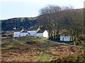
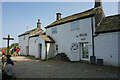
Springs and Holy WellsSite Name: White Wells (Ilkley) Alternative Name: Ilkley Spaw; Mountain Spa (Ilkley); Spa Well (Ilkley)Country: England County: Yorkshire (West) Type: Holy Well or Sacred Spring
Nearest Town: Ilkley
Map Ref: SE11814677
Latitude: 53.916943N Longitude: 1.82168W
Condition:
| 5 | Perfect |
| 4 | Almost Perfect |
| 3 | Reasonable but with some damage |
| 2 | Ruined but still recognisable as an ancient site |
| 1 | Pretty much destroyed, possibly visible as crop marks |
| 0 | No data. |
| -1 | Completely destroyed |
| 5 | Superb |
| 4 | Good |
| 3 | Ordinary |
| 2 | Not Good |
| 1 | Awful |
| 0 | No data. |
| 5 | Can be driven to, probably with disabled access |
| 4 | Short walk on a footpath |
| 3 | Requiring a bit more of a walk |
| 2 | A long walk |
| 1 | In the middle of nowhere, a nightmare to find |
| 0 | No data. |
| 5 | co-ordinates taken by GPS or official recorded co-ordinates |
| 4 | co-ordinates scaled from a detailed map |
| 3 | co-ordinates scaled from a bad map |
| 2 | co-ordinates of the nearest village |
| 1 | co-ordinates of the nearest town |
| 0 | no data |
Internal Links:
External Links:
 (PID:229174)")
The Northern Antiquarian (TNA) features a page for this sacred well - see their entry for White Wells, Ilkley, West Yorkshire, which gives directions for finding this site, an image of the 1851 OS map showing the location of the well (shown as Spa Well), photographs (including an early photograph) and descriptions from 18th, 19th, 20th and 21st century publications.
Pastscape does not record this well (see Pastscape Monument No. 49844), which gives details of a "Possible Roman conduit comprising channel-stones was identified between Ilkley and the spring above White Wells. The channel-stones were reported to be preserved in Spence's Gardens. Field investigations in 1964 failed to locate the precise site of the conduit or the current location of the channel stones."
You may be viewing yesterday's version of this page. To see the most up to date information please register for a free account.
 (PID:231177)")
 (PID:229176)")
 (PID:229175)")
Do not use the above information on other web sites or publications without permission of the contributor.
Nearby Images from Geograph Britain and Ireland:
©2014(licence)
©2021(licence)
©2023(licence)
©2020(licence)
©2023(licence)
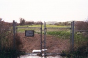
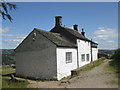
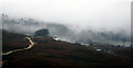
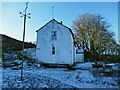
The above images may not be of the site on this page, they are loaded from Geograph.
Please Submit an Image of this site or go out and take one for us!
Click here to see more info for this site
Nearby sites
Key: Red: member's photo, Blue: 3rd party photo, Yellow: other image, Green: no photo - please go there and take one, Grey: site destroyed
Download sites to:
KML (Google Earth)
GPX (GPS waypoints)
CSV (Garmin/Navman)
CSV (Excel)
To unlock full downloads you need to sign up as a Contributory Member. Otherwise downloads are limited to 50 sites.
Turn off the page maps and other distractions
Nearby sites listing. In the following links * = Image available
104m ESE 123° White Wells 07 Rock Art (SE1189846714)
208m S 178° White Wells 05* Rock Art (SE1181646562)
220m S 180° White Wells 04 Rock Art (SE1181046550)
224m S 181° Pepperpot Rock* Rock Art (SE1180746546)
226m S 181° White Wells 02* Rock Art (SE1180746544)
230m S 184° White Wells 01* Rock Art (SE1179446540)
237m S 177° White Wells 06* Rock Art (SE1182246533)
287m SW 232° Willy Hall's Wood Stone* Rock Art (SE1158446592)
491m NE 53° The Tarn 01 Rock Art (SE1220047070)
493m SE 126° Ilkley Crags* Rock Art (SE1221046480)
599m SE 135° Cranshaw Thorn Hill 01* Rock Art (SE1223346344)
602m SE 133° Cranshaw Thorn Hill 04* Rock Art (SE1225646364)
606m SE 135° Cranshaw Thorn Hill 03* Rock Art (SE1224446346)
614m SE 136° Cranshaw Thorn Hill 02 Rock Art (SE1224046330)
617m NNW 327° Panorama Stone* Rock Art (SE1147147287)
620m NNW 327° Panorama Rocks 02* Rock Art (SE1146747287)
620m NNW 327° Panorama Rocks 03* Rock Art (SE1146847288)
622m SE 133° Cranshaw Thorn Hill Rock Art (SE12274635)
683m SE 128° Cranshaw Thorn Hill 07 Rock Art (SE1235046350)
690m SE 132° Cranshaw Thorn Hill 05* Rock Art (SE1232846312)
709m WSW 240° Barmishaw Stone* Rock Art (SE1119246419)
738m E 87° Backstone Beck (Cowpasture Road) Rock Art (SE1254946814)
754m SE 136° Cranshaw Thorn Hill 06* Rock Art (SE1233846230)
776m WSW 247° Barmishaw 01* Rock Art (SE1109746460)
784m SSW 203° Green Gates 06* Rock Art (SE1149946049)
View more nearby sites and additional images


 We would like to know more about this location. Please feel free to add a brief description and any relevant information in your own language.
 Wir möchten mehr über diese Stätte erfahren. Bitte zögern Sie nicht, eine kurze Beschreibung und relevante Informationen in Deutsch hinzuzufügen.
 Nous aimerions en savoir encore un peu sur les lieux. S'il vous plaît n'hesitez pas à ajouter une courte description et tous les renseignements pertinents dans votre propre langue.
 Quisieramos informarnos un poco más de las lugares. No dude en añadir una breve descripción y otros datos relevantes en su propio idioma.