


<< Our Photo Pages >> Maggie Cross - Ancient Cross in England in Devon
Submitted by SMacB on Saturday, 17 June 2017 Page Views: 1072
Early Medieval (Dark Age)Site Name: Maggie Cross Alternative Name: St Margaret’s Cross, Postbridge CrossCountry: England County: Devon Type: Ancient Cross
Nearest Town: Postbridge
Map Ref: SX6516679216
Latitude: 50.597051N Longitude: 3.906463W
Condition:
| 5 | Perfect |
| 4 | Almost Perfect |
| 3 | Reasonable but with some damage |
| 2 | Ruined but still recognisable as an ancient site |
| 1 | Pretty much destroyed, possibly visible as crop marks |
| 0 | No data. |
| -1 | Completely destroyed |
| 5 | Superb |
| 4 | Good |
| 3 | Ordinary |
| 2 | Not Good |
| 1 | Awful |
| 0 | No data. |
| 5 | Can be driven to, probably with disabled access |
| 4 | Short walk on a footpath |
| 3 | Requiring a bit more of a walk |
| 2 | A long walk |
| 1 | In the middle of nowhere, a nightmare to find |
| 0 | No data. |
| 5 | co-ordinates taken by GPS or official recorded co-ordinates |
| 4 | co-ordinates scaled from a detailed map |
| 3 | co-ordinates scaled from a bad map |
| 2 | co-ordinates of the nearest village |
| 1 | co-ordinates of the nearest town |
| 0 | no data |
Internal Links:
External Links:
")
You may be viewing yesterday's version of this page. To see the most up to date information please register for a free account.
")
Do not use the above information on other web sites or publications without permission of the contributor.
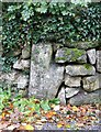
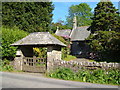
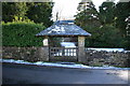
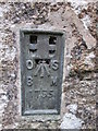
Nearby Images from Geograph Britain and Ireland:
©2019(licence)
©2012(licence)
©2010(licence)
©2014(licence)
©2006(licence)
The above images may not be of the site on this page, they are loaded from Geograph.
Please Submit an Image of this site or go out and take one for us!
Click here to see more info for this site
Nearby sites
Key: Red: member's photo, Blue: 3rd party photo, Yellow: other image, Green: no photo - please go there and take one, Grey: site destroyed
Download sites to:
KML (Google Earth)
GPX (GPS waypoints)
CSV (Garmin/Navman)
CSV (Excel)
To unlock full downloads you need to sign up as a Contributory Member. Otherwise downloads are limited to 50 sites.
Turn off the page maps and other distractions
Nearby sites listing. In the following links * = Image available
509m WNW 300° Ringhill Stone Row / Alignment (SX64737948)
652m SW 233° National Park Visitors Centre Postbridge* Museum (SX6463578836)
791m W 260° Archerton Newtake Cist* Cist (SX6438179105)
966m SSW 209° Lakehead Newtake Cist* Cairn (SX64687838)
1.1km WSW 247° Archerton Settlement* Ancient Village or Settlement (SX6410078800)
1.3km WNW 288° Roundy Park settlement* Ancient Village or Settlement (SX63977964)
1.3km SSW 213° Kraps Ring* Ancient Village or Settlement (SX64427814)
1.3km WNW 289° Roundy Park Cairn* Cairn (SX6392079669)
1.4km WSW 253° Archerton Tennis Court cist* Cist (SX63847886)
1.5km W 278° Chittaford Down Platform Cairn Circle and Cist* Cairn (SX6368779463)
1.7km SSW 208° Lakehead Cairn Circle 1* Ring Cairn (SX6435677766)
1.7km W 268° Chittaford Down cairn circle and cist* Cist (SX6350179193)
1.7km SSW 201° Lakehead Hill E* Stone Row / Alignment (SX6449577603)
1.7km SSW 205° Lakehead Hill W* Stone Row / Alignment (SX6437977653)
1.8km WNW 302° Broadun Ring* Ancient Village or Settlement (SX6369980178)
1.8km WNW 292° Broadun Settlement* Ancient Village or Settlement (SX6354179928)
1.8km SSW 210° Lakehead Hill 2* Cist (SX6425077696)
1.8km SSW 204° Lakehead Hill* Stone Row / Alignment (SX644776)
1.9km N 8° Stannon Newtake cist* Cist (SX65468105)
1.9km SSW 193° Lakehead Hill SE Stone Row* Stone Row / Alignment (SX64707740)
1.9km SSW 192° Lakehead Hill Cairn 7* Cairn (SX6471477389)
1.9km N 3° Stannon Newtake West Cairn and row* Multiple Stone Rows / Avenue (SX65338110)
1.9km SSW 204° Lakehead Hill 5* Stone Circle (SX6434677486)
1.9km SSW 203° Lakehead Hill 6* Cairn (SX6435877467)
2.0km SSW 195° Lakehead Hill South Hut Circle* Ancient Village or Settlement (SX6459177291)
View more nearby sites and additional images


 We would like to know more about this location. Please feel free to add a brief description and any relevant information in your own language.
 Wir möchten mehr über diese Stätte erfahren. Bitte zögern Sie nicht, eine kurze Beschreibung und relevante Informationen in Deutsch hinzuzufügen.
 Nous aimerions en savoir encore un peu sur les lieux. S'il vous plaît n'hesitez pas à ajouter une courte description et tous les renseignements pertinents dans votre propre langue.
 Quisieramos informarnos un poco más de las lugares. No dude en añadir una breve descripción y otros datos relevantes en su propio idioma.