Featured: Hare and Tabor T Shirts for discerning antiquarians

Hare and Tabor T Shirts for discerning antiquarians

A Little History of Astro-Archaeology £4.99+p&p

A Little History of Astro-Archaeology £4.99+p&p

Who's Online

There are currently, 285 guests and 2 members online.

You are a guest. To join in, please register for free by clicking here

Sponsors

<< Our Photo Pages >> Lakehead Hill E - Stone Row / Alignment in England in Devon

Submitted by simonsworn on Tuesday, 01 October 2002  Page Views: 5746

Neolithic and Bronze AgeSite Name: Lakehead Hill E Alternative Name: Lakehead Hill 4; Grinsell Lydford 54; Turner D6; Dixon 68
Country: England County: Devon Type: Stone Row / Alignment
Nearest Town: Princetown  Nearest Village: Postbridge
Map Ref: SX6449577603  Landranger Map Number: 191
Latitude: 50.582398N  Longitude: 3.91535W
Condition:
5Perfect
4Almost Perfect
3Reasonable but with some damage
2Ruined but still recognisable as an ancient site
1Pretty much destroyed, possibly visible as crop marks
0No data.
-1Completely destroyed
4 Ambience:
5Superb
4Good
3Ordinary
2Not Good
1Awful
0No data.
4 Access:
5Can be driven to, probably with disabled access
4Short walk on a footpath
3Requiring a bit more of a walk
2A long walk
1In the middle of nowhere, a nightmare to find
0No data.
3 Accuracy:
5co-ordinates taken by GPS or official recorded co-ordinates
4co-ordinates scaled from a detailed map
3co-ordinates scaled from a bad map
2co-ordinates of the nearest village
1co-ordinates of the nearest town
0no data
5

Internal Links:
External Links:

I have visited· I would like to visit

jimstone would like to visit

Catrinm visited on 12th Feb 2023 - their rating: Cond: 4 Amb: 4 Access: 4

Catrinm visited on 12th Feb 2023 - their rating: Cond: 4 Amb: 4 Access: 4

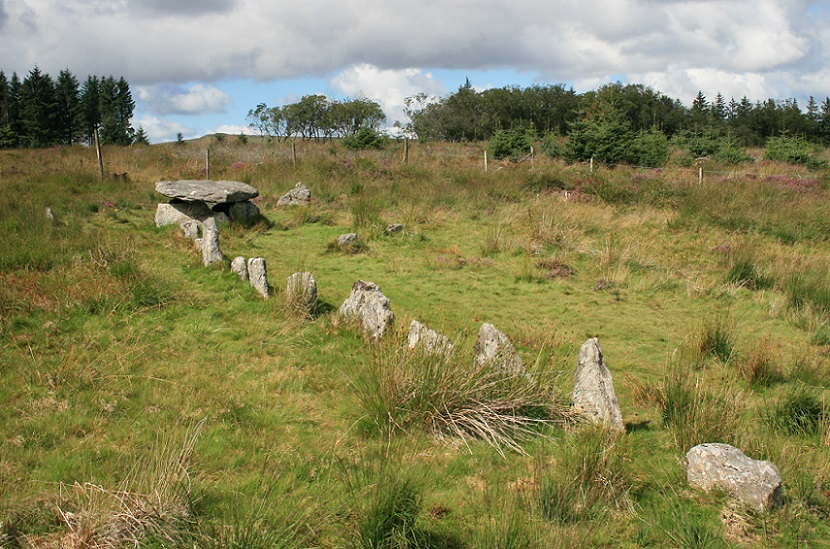
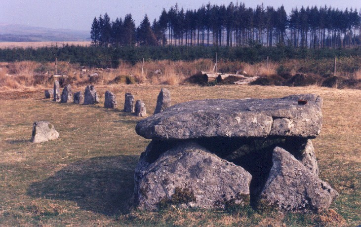
TheCaptain visited on 18th Sep 2020 - their rating: Cond: 4 Amb: 4 Access: 3 Carry on northwards and then left in the scrubby gap between the forest trees to what the OS mark as "Cairn Circle & Cist". A path leads on westwards and then there it is, the coverstar of the Lakehead Hill sites. A short stone row leads westwards to a large rectangular box structure, all in a very nicely tended open area. I suspect this has all been "restored", but it does look very pretty in the afternoon sunshine. These days eleven stones make the row leading westwards to the cist, with a kink in the middle. The cist is a large box structure, much bigger than most of the cists on Dartmoor, and I think could be considered more of a burial chamber. This is partially surrounded by a circle of half a dozen small stones, although this has probably not been reconstructed very accurately. I like it.

graemefield visited on 3rd Aug 2008 - their rating: Cond: 3 Amb: 5 Access: 2

AngieLake cazzyjane have visited here

Average ratings for this site from all visit loggers: Condition: 3.75 Ambience: 4.25 Access: 3.25
Lakehead Hill E
Lakehead Hill E submitted by postman : Stone row, stone circle and big cist, I never told my wife our weekend away was just so I could come here, don't think she would've been dead impressed. (Vote or comment on this photo)
A short stone row leads up a circle of stones surrounding a covered kist. The row has suffered the fate of being excavated and 'restored' in 1895 by the Dartmoor Exploration Committee, so many of the features seen today are unlikely to have been original. Yet the kink in the row as it approaches the circle is similar to many other rows on the moors. There were no finds recovered.

Update November 2019: The Lakehead Hill E stone row is featured on the Stone Rows of Britain website. Their entry includes a description, a plan of the row and its associated cairn, photographs of the alignment and its large cist, access information and a list of online resources for more information.

The row and its cairn are also recorded as Pastscape Monument No. 442599 and as MDV5873 (Stone alignment with cist on Lakehead Hill) on the Devon and Dartmoor HER. The site is also scheduled as part of Historic England List Entry No. 1018510 (Five cairns, two stone alignments and three cists, forming part of a ritual complex on Lakehead Hill).

The row is also featured on the Prehistoric Dartmoor Walks (PDW) website - see their entries for the Lakehead Hill 4 (E of Summit) Stone Row and the Lakehead Hill Cairn Circles, Cists and Settlements. PDW also includes a separate page for the Lakehead Hill 4 (E or Summit) Ring Setting Cairn and Cist, which is also known as Grinsell's Lydford 54, Turner's D6, Dixon's #68 and Butlers Lakehead Hill (Cairn 4, V2 27.19.4). PDW tells us: "(This is) a single stone row of at least 11 stones leading westward towards the cairn and cist. The cairn measures 6.7 metres in diameter and is defined by several edge set stones, which in turn surround a large restored cist formed by five substantial upright slabs supporting a capstone measuring 2.2 metre long by 1.55 metres wide and 0.3 metres thick".
You may be viewing yesterday's version of this page. To see the most up to date information please register for a free account.
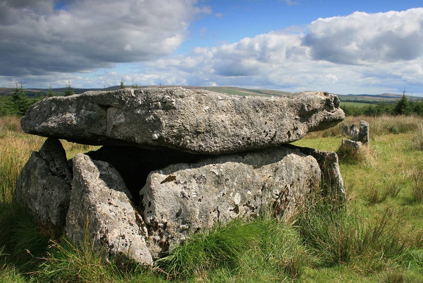
Lakehead Hill E
Lakehead Hill E submitted by cazzyjane : A lovely site but difficult to see the curving stone row behind due to the fog! (3 comments - Vote or comment on this photo)

Lakehead Hill E
Lakehead Hill E submitted by AngieLake : Lakehead Hill in Spring 07. (View to SE?) (Vote or comment on this photo)

Lakehead Hill E
Lakehead Hill E submitted by postman : A very good central cist, well worth the three hundred mile trip, not sure wife would agree. (Vote or comment on this photo)

Lakehead Hill E
Lakehead Hill E submitted by AngieLake : Lakehead Hill and in the distance, the long ridge of Hameldown, with its many barrows. (1 comment - Vote or comment on this photo)

Lakehead Hill E
Lakehead Hill E submitted by TheCaptain : A look round the Lakehead Hill 4 cist and row. The short stone row leads westwards to a large rectangular box structure, all in a very nicely tended open area, and it does look very pretty in the afternoon sunshine. I like it. (1 comment)

Lakehead Hill E
Lakehead Hill E submitted by TheCaptain (1 comment)

Lakehead Hill E
Lakehead Hill E submitted by postman : Blue skies and fluffy white clouds, good stones.

Lakehead Hill E
Lakehead Hill E submitted by AngieLake : Alignment through the centre here: from the pine cone on the capstone, to the fence post, and the highest part of Hameldown's ridge was 68 degs.

Lakehead Hill E
Lakehead Hill E submitted by Bladup : Lakehead Hill E.

Lakehead Hill E
Lakehead Hill E submitted by postman : Definitely a place to linger.

Lakehead Hill E
Lakehead Hill E submitted by postman : Cist and circle

Lakehead Hill E
Lakehead Hill E submitted by AngieLake : Because the two nearest stones were like portals I crouched down to take this shot, trying to see the horizon behind the trees. I made a note of the bearing as '120 degs', where there could be a dip in the distant hills.

Lakehead Hill E
Lakehead Hill E submitted by AngieLake : The kist looks really 'boxy' at this angle.

Lakehead Hill E
Lakehead Hill E submitted by AngieLake : Looking approx East along the row.

Lakehead Hill E
Lakehead Hill E submitted by ernar : Close shot of the covered Kist in Lakehead Hill E. (1 comment)

Lakehead Hill E
Lakehead Hill E submitted by Bladup : Lakehead Hill

Lakehead Hill E
Lakehead Hill E submitted by TheCaptain : A look round the Lakehead Hill 4 cist and row. The short stone row leads westwards to a large rectangular box structure, all in a very nicely tended open area, and it does look very pretty in the afternoon sunshine. I like it.

Lakehead Hill E
Lakehead Hill E submitted by TheCaptain

Lakehead Hill E
Lakehead Hill E submitted by TheCaptain

Lakehead Hill E
Lakehead Hill E submitted by TheCaptain

Lakehead Hill E
Lakehead Hill E submitted by Bladup : Lakehead Hill E.

Lakehead Hill E
Lakehead Hill E submitted by Bladup

Lakehead Hill E
Lakehead Hill E submitted by postman : No this is the central cist.

Lakehead Hill E
Lakehead Hill E submitted by postman : The central cist

These are just the first 25 photos of Lakehead Hill E. If you log in with a free user account you will be able to see our entire collection.

Do not use the above information on other web sites or publications without permission of the contributor.
Click here to see more info for this site

Nearby sites

Click here to view sites on an interactive OS map

Key: Red: member's photo, Blue: 3rd party photo, Yellow: other image, Green: no photo - please go there and take one, Grey: site destroyed

Download sites to:
KML (Google Earth)
GPX (GPS waypoints)
CSV (Garmin/Navman)
CSV (Excel)

To unlock full downloads you need to sign up as a Contributory Member. Otherwise downloads are limited to 50 sites.

Prehistoric Circles and Rows by Ian Honeywood


Turn off the page maps and other distractions

Nearby sites listing. In the following links * = Image available
 95m W 267° Lakehead Hill* Stone Row / Alignment (SX644776)
 126m WNW 292° Lakehead Hill W* Stone Row / Alignment (SX6437977653)
 189m SW 230° Lakehead Hill 5* Stone Circle (SX6434677486)
 193m SW 224° Lakehead Hill 6* Cairn (SX6435877467)
 214m NW 318° Lakehead Cairn Circle 1* Ring Cairn (SX6435677766)
 261m WNW 289° Lakehead Hill 2* Cist (SX6425077696)
 288m SE 133° Lakehead Hill SE Stone Row* Stone Row / Alignment (SX64707740)
 306m SE 133° Lakehead Hill Cairn 7* Cairn (SX6471477389)
 326m SSE 161° Lakehead Hill South Hut Circle* Ancient Village or Settlement (SX6459177291)
 436m SW 225° Lakehead Hill South West Stone Row / Alignment (SX64187730)
 479m SSE 151° Lakehead Hill Cairn 8* Cairn (SX6471777178)
 542m N 351° Kraps Ring* Ancient Village or Settlement (SX64427814)
 783m S 180° Bellever Tor N Settlement* Ancient Village or Settlement (SX64487682)
 798m NNE 12° Lakehead Newtake Cist* Cairn (SX64687838)
 927m SSE 155° Bellever Tor NE Settlement* Ancient Village or Settlement (SX64867675)
 1.2km SSW 198° Bellever Tor Cairn one* Cist (SX6408976465)
 1.2km N 5° National Park Visitors Centre Postbridge* Museum (SX6463578836)
 1.3km NNW 340° Archerton Settlement* Ancient Village or Settlement (SX6410078800)
 1.4km W 279° Arch Tor* Cairn (SX63167784)
 1.4km SSW 193° Bellever Tor 2* Cairn (SX6414076270)
 1.4km NNW 331° Archerton Tennis Court cist* Cist (SX63847886)
 1.5km SSW 211° Black Newtake Enclosure Ancient Village or Settlement (SX63707636)
 1.5km N 354° Archerton Newtake Cist* Cist (SX6438179105)
 1.6km SSW 199° Bellever Tor 3* Cairn (SX63917606)
 1.7km SSW 200° Bellever Tor 4* Ring Cairn (SX63867603)
View more nearby sites and additional images

<< Down Tor stone row

Lakehead Hill W >>

Please add your thoughts on this site

Prehistoric Settlements

Prehistoric Settlements

Archived Web links for Lakehead Hill E

Prehistoric Circles and Rows by Ian Honeywood

Sponsors

Auto-Translation (Google)

Translate from English into:

"Lakehead Hill E" | Login/Create an Account | 4 News and Comments
  
Go back to top of page    Comments are owned by the poster. We aren't responsible for their content.
Re: Lakehead Hill East, or Butler's 'Lakehead Hill 4'. by davep on Wednesday, 13 July 2011
(User Info | Send a Message)
There are numerous sites in close proximity on Lakehead Hill. These are covered in detail in Butler's Atlas of Antiquities Vol 2. Map 27 Site 19 (see pp. 48-52). The stone row, cist and cairn circle (Butler no.4) is marked with a Dartmoor National Park posts 14A & 15A. The precise location on Streetmap UK is SX64537760
[ Reply to This ]

Re: Lakehead Hill East, or Butler's 'Lakehead Hill 4'. by AngieLake on Tuesday, 08 December 2009
(User Info | Send a Message)
If you want to use an alternate name for this site on Lakehead Hill, Butler calls it no. 4. 'Cairn, Cist and Stone Row'.

In his description, he says:
"A muddy track.. [suppose it can be sometimes, but it isn't surrounded by forest these days] .. leads through the plantation to the circle, cist and stone row 4 (fig. 27.13.4) [ref to diagram in his book, Dartmoor Atlas of Antiquities, Vol 2 - The North'].
The row runs downhill from the cist of five slabs topped with a massive capstone and surrounded by a retaining circle of which six stones remain. The cairn material had been entirely removed long before the Dartmoor Exploration Committee re-erected the cist and many of the stones in 1895. The restoration was probably inaccurate and at least one of the circle stones seems to have been misplaced outwards giving the impression that the row starts from within the circumference. The smaller circle shown on the plan best fits the majority of stones (diam. 6.7m) but places the cist well off-centre. In addition to the 11 stones of the row the sockets of two more were uncovered in 1895 but these are no longer visible. An exceptional feature is the marked alteration of course northwards after the fifth stone. Rather surprisingly, although the Committee's description of the cist as 'perfect' must be taken as an exaggeration considering all the stones were flat when found, there was no mention of any artefacts being recovered during the restoration."
[ Reply to This ]

Re: Lakehead Hill 'Metropolis of the Moor' by AngieLake on Wednesday, 25 November 2009
(User Info | Send a Message)
In Butler's 'Dartmoor Atlas of Antiquities - Vol.5 - The Second Millennium BC', he writes about this area:

"The consequences ... [of the forestry plantations] ... in the Lakehead Hill/Bellever/Laughter Tor region are, if anything, even more catastrophic to what could once genuinely be claimed as a site of national importance. Labelled the 'ancient metropolis of the Moor' with good reason, these hills were once crowned with numerous burial cairns and stone alignments, and were surrounded on all sides by a multitude of settlements. The early, rather imprecise, surveys are confused and many settlement sites represented now by isolated hut circles or stray banks disappearing into the trees were not documented at all."
[ Reply to This ]

Re: Lakehead Hill E by AngieLake on Wednesday, 25 November 2009
(User Info | Send a Message)
In 'Guide to Prehistoric England' by Nicholas Thomas, [Book Club Associates, 1977]:
"Lakehead, cairn, cist, row (SX/645776) 2 3/4".. [two and three-quarter].."miles NE of Two Bridges (A384, B3212), N of track to Bellever.
Here is a fine stone cist with its capstone, recently restored. Around it are 6 stones of a circle of diam. about 25ft. Starting within the circle and leading E for 44ft. is a single stone row."
[ Reply to This ]

Your Name: Anonymous [ Register Now ]
Subject:


Add your comment or contribution to this page. Spam or offensive posts are deleted immediately, don't even bother

<<< What is five plus one as a number? (Please type the answer to this question in the little box on the left)
You can also embed videos and other things. For Youtube please copy and paste the 'embed code'.
For Google Street View please include Street View in the text.
Create a web link like this: <a href="https://www.megalithic.co.uk">This is a link</a>  

Allowed HTML is:
<p> <b> <i> <a> <img> <em> <br> <strong> <blockquote> <tt> <li> <ol> <ul> <object> <param> <embed> <iframe>

We would like to know more about this location. Please feel free to add a brief description and any relevant information in your own language.
Wir möchten mehr über diese Stätte erfahren. Bitte zögern Sie nicht, eine kurze Beschreibung und relevante Informationen in Deutsch hinzuzufügen.
Nous aimerions en savoir encore un peu sur les lieux. S'il vous plaît n'hesitez pas à ajouter une courte description et tous les renseignements pertinents dans votre propre langue.
Quisieramos informarnos un poco más de las lugares. No dude en añadir una breve descripción y otros datos relevantes en su propio idioma.