<< Our Photo Pages >> Stannon Newtake West Cairn and row - Multiple Stone Rows / Avenue in England in Devon
Submitted by theCaptain on Monday, 30 September 2002 Page Views: 5862
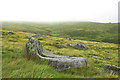
Neolithic and Bronze AgeSite Name: Stannon Newtake West Cairn and row Alternative Name: Butler (map 35.21)Country: England County: Devon Type: Multiple Stone Rows / Avenue
Nearest Town: Moretonhampstead Nearest Village: Postbridge
Map Ref: SX65338110 Landranger Map Number: 191
Latitude: 50.614022N Longitude: 3.904831W
Condition:
| 5 | Perfect |
| 4 | Almost Perfect |
| 3 | Reasonable but with some damage |
| 2 | Ruined but still recognisable as an ancient site |
| 1 | Pretty much destroyed, possibly visible as crop marks |
| 0 | No data. |
| -1 | Completely destroyed |
| 5 | Superb |
| 4 | Good |
| 3 | Ordinary |
| 2 | Not Good |
| 1 | Awful |
| 0 | No data. |
| 5 | Can be driven to, probably with disabled access |
| 4 | Short walk on a footpath |
| 3 | Requiring a bit more of a walk |
| 2 | A long walk |
| 1 | In the middle of nowhere, a nightmare to find |
| 0 | No data. |
| 5 | co-ordinates taken by GPS or official recorded co-ordinates |
| 4 | co-ordinates scaled from a detailed map |
| 3 | co-ordinates scaled from a bad map |
| 2 | co-ordinates of the nearest village |
| 1 | co-ordinates of the nearest town |
| 0 | no data |
Internal Links:
External Links:
I have visited· I would like to visit
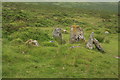
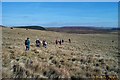
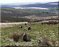
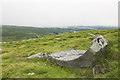
TheCaptain visited on 3rd May 2022 - their rating: Cond: 2 Amb: 3 Access: 2 From the Stannon Newtake cairn with cist, I tried to get to the cairn with possible small stone row which is nearby down the hill. However, I could not get through all the chest height gorse and heather to find it. I do think that I saw a couple of the larger stones further down, standing in a cleared area. I later find out that the whole length of the White Ridge stone row has been cleared and links up with these stones, which are possibly the end of that long row.
")
Possibly associated with this cairn are several stones to the southeast, two of which still stand and may be blocking stones for two short stone rows extending from the cairn.
Update December 2019: This row is featured on the Stone Rows of Great Britain - see their entry for the Stannon Newtake, which tells us: "Following vegetation clearance by the Dartmoor Preservation Association it was found that this line of stones forms part of the White Ridge stone row and is not a row in its own right".
This site is also recorded as Pastscape Monument No. 917480, as MDV54555 (Alignment) on the Devon and Dartmoor HER, and scheduled as part of Historic England List Entry No. 1021339 (Coaxial fields, prehistoric settlement, two cairns and a stone alignment in Little Stannon Newtake, 900m south east of Stannon Tor).
You may be viewing yesterday's version of this page. To see the most up to date information please register for a free account.
")
Do not use the above information on other web sites or publications without permission of the contributor.
Nearby Images from Geograph Britain and Ireland:
©2009(licence)
©2006(licence)
©2020(licence)
©2010(licence)
©2010(licence)
The above images may not be of the site on this page, they are loaded from Geograph.
Please Submit an Image of this site or go out and take one for us!
Click here to see more info for this site
Nearby sites
Key: Red: member's photo, Blue: 3rd party photo, Yellow: other image, Green: no photo - please go there and take one, Grey: site destroyed
Download sites to:
KML (Google Earth)
GPX (GPS waypoints)
CSV (Garmin/Navman)
CSV (Excel)
To unlock full downloads you need to sign up as a Contributory Member. Otherwise downloads are limited to 50 sites.
![]()
![]()
Turn off the page maps and other distractions
Nearby sites listing. In the following links * = Image available
139m ESE 110° Stannon Newtake cist* Cist (SX65468105)
465m N 7° White Ridge stone row* Stone Row / Alignment (SX65408156)
1.1km NNW 343° White Ridge cairn* Round Cairn (SX65028218)
1.3km WNW 292° White Ridge SW cairn* Round Cairn (SX64158162)
1.3km WNW 302° White Ridge SW settlements* Ancient Village or Settlement (SX64258181)
1.4km WNW 283° Lade Hill Brook Beehive Hut* Ancient Mine, Quarry or other Industry (SX63938145)
1.7km NNE 24° Assycombe* Multiple Stone Rows / Avenue (SX66058260)
1.7km NNE 25° Assycombe Hill* Cairn (SX66108264)
1.7km SSW 199° Ringhill Stone Row / Alignment (SX64737948)
1.8km E 83° Water hill cairn* Cairn (SX67158128)
1.9km WSW 239° Broadun Ring* Ancient Village or Settlement (SX6369980178)
1.9km S 183° Maggie Cross* Ancient Cross (SX6516679216)
1.9km NW 322° White Ridge pound* Ring Cairn (SX6416882656)
1.9km NW 322° White Ridge Standing Stone* Standing Stone (Menhir) (SX6416282653)
2.0km NW 317° Sittaford Marsh Hut Circles* Ancient Village or Settlement (SX6402982560)
2.0km SW 221° Roundy Park settlement* Ancient Village or Settlement (SX63977964)
2.0km SW 223° Roundy Park Cairn* Cairn (SX6392079669)
2.1km SW 235° Broadun Settlement* Ancient Village or Settlement (SX6354179928)
2.1km NW 323° South Teignhead* Cairn (SX64088284)
2.2km SSW 204° Archerton Newtake Cist* Cist (SX6438179105)
2.2km NW 322° Sittaford Tor pound* Misc. Earthwork (SX64018288)
2.3km SW 224° Chittaford Down Platform Cairn Circle and Cist* Cairn (SX6368779463)
2.4km SSW 196° National Park Visitors Centre Postbridge* Museum (SX6463578836)
2.4km NE 53° Hurston Ridge* Multiple Stone Rows / Avenue (SX67308251)
2.4km NW 308° Sittaford Tor Cairn* Cairn (SX6346182650)
View more nearby sites and additional images


 We would like to know more about this location. Please feel free to add a brief description and any relevant information in your own language.
 Wir möchten mehr über diese Stätte erfahren. Bitte zögern Sie nicht, eine kurze Beschreibung und relevante Informationen in Deutsch hinzuzufügen.
 Nous aimerions en savoir encore un peu sur les lieux. S'il vous plaît n'hesitez pas à ajouter une courte description et tous les renseignements pertinents dans votre propre langue.
 Quisieramos informarnos un poco más de las lugares. No dude en añadir una breve descripción y otros datos relevantes en su propio idioma.