<< Our Photo Pages >> Fox Tor Newtake South - Cairn in England in Devon
Submitted by Anne T on Thursday, 06 October 2016 Page Views: 1004
Neolithic and Bronze AgeSite Name: Fox Tor Newtake South Alternative Name: Butler Ter Hill NW 2; Dixon 20; Grinsell Lydford 98Country: England County: Devon Type: Cairn
Nearest Town: Plymouth Nearest Village: Whiteworks
Map Ref: SX62867097
Latitude: 50.522400N Longitude: 3.935986W
Condition:
| 5 | Perfect |
| 4 | Almost Perfect |
| 3 | Reasonable but with some damage |
| 2 | Ruined but still recognisable as an ancient site |
| 1 | Pretty much destroyed, possibly visible as crop marks |
| 0 | No data. |
| -1 | Completely destroyed |
| 5 | Superb |
| 4 | Good |
| 3 | Ordinary |
| 2 | Not Good |
| 1 | Awful |
| 0 | No data. |
| 5 | Can be driven to, probably with disabled access |
| 4 | Short walk on a footpath |
| 3 | Requiring a bit more of a walk |
| 2 | A long walk |
| 1 | In the middle of nowhere, a nightmare to find |
| 0 | No data. |
| 5 | co-ordinates taken by GPS or official recorded co-ordinates |
| 4 | co-ordinates scaled from a detailed map |
| 3 | co-ordinates scaled from a bad map |
| 2 | co-ordinates of the nearest village |
| 1 | co-ordinates of the nearest town |
| 0 | no data |
Be the first person to rate this site - see the 'Contribute!' box in the right hand menu.
Internal Links:
External Links:
")
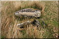
Sitting 200 metres from Fox Tor Newtake North, this site is featured on the Prehistoric Dartmoor Walks website as the Fox Tor Newtake, South Cist . It is described as "the turf-covered cairn is, at maximum, 3.9m in diameter and 0.3m in height. The cist, oriented NW/SE, is approximately 1.3m by 0.55m, and 0.75m deep, and now almost hidden by the SW side stone which has fallen inwards. The NE end stone is not evident but an 0.7m high upright granite post retains part of the mound on this NE side. There is no trace of the coverstone."
Further information can also be found on the Pastscape website, see Monument Number 443325, which tells us that "Investigations by Mr Burnard in 1905 were abandoned when a broken beer bottle was found at the base of a side stone."
The Heritage Gateway for Devon & Dartmoor HER number MDV6279, dates the cairn with cist to the Bronze Age (2200 BC to 701 BC). The scheduling information (Historic England List ID 1002592 (Two cairns with cists E of Whiteworks tin mine buildings)) also covers its neighbour, Fox Tor Newtake North Cist.
You may be viewing yesterday's version of this page. To see the most up to date information please register for a free account.
Do not use the above information on other web sites or publications without permission of the contributor.
Nearby Images from Geograph Britain and Ireland:
©2009(licence)
©2007(licence)
©2009(licence)
©2014(licence)

©2014(licence)
The above images may not be of the site on this page, they are loaded from Geograph.
Please Submit an Image of this site or go out and take one for us!
Click here to see more info for this site
Nearby sites
Key: Red: member's photo, Blue: 3rd party photo, Yellow: other image, Green: no photo - please go there and take one, Grey: site destroyed
Download sites to:
KML (Google Earth)
GPX (GPS waypoints)
CSV (Garmin/Navman)
CSV (Excel)
To unlock full downloads you need to sign up as a Contributory Member. Otherwise downloads are limited to 50 sites.
Turn off the page maps and other distractions
Nearby sites listing. In the following links * = Image available
190m N 359° Fox Tor Newtake North* Cist (SX62867116)
730m SSW 202° Childe’s Tomb* Cairn (SX62577030)
1.1km NNE 16° Joan Ford Newtake row* Multiple Stone Rows / Avenue (SX6318071989)
1.1km WSW 239° Goldsmith Cross E1 Cist (SX61877040)
1.2km NNE 12° Joan Ford Newtake E* Cairn (SX63147216)
1.2km ESE 105° Ter Hill Cross Ancient Cross (SX6403670623)
1.2km N 7° Joan Ford Newtake W* Cairn (SX63047218)
1.2km WSW 237° Rha cairn circle and cist* Cist (SX6180470321)
1.3km N 3° Tor Royal Cairn (SX62967224)
1.4km SW 234° Goldsmith's Cross E3 Cist (SX6174170204)
1.4km NW 321° Royal Hill Cairns (SX620721)* Cairn (SX6201872079)
1.4km NW 312° Royal Hill Cairns (SX618719)* Cairn (SX6181271945)
1.5km NW 324° Royal Hill Cairns* Cairn (SX620722)
1.6km NNW 329° Royal Hill Cairns (SX621723)* Cairn (SX6208272334)
1.6km SW 225° Whealam cist* Cist (SX61666985)
1.6km NNW 331° Royal Hill Cairns (SX621724)* Cairn (SX6210872434)
2.1km NNE 11° Swincombe cairn circle and cist* Cist (SX63327298)
2.2km WSW 255° Whiteworks Cairn Circle* Cairn (SX60767047)
2.2km E 96° Skir Hill* Cairn (SX65097068)
2.4km NW 318° Royal Hill Summit* Cairn (SX61307279)
2.5km NNE 25° Sherberton circle* Stone Circle (SX6394073173)
2.5km NNW 346° Tor Royal Newtake Stone Row / Alignment (SX623734)
2.6km NNW 346° Moorlands Farm stone row Stone Row / Alignment (SX623735)
2.6km NNE 22° Sherberton Row* Stone Row / Alignment (SX63917336)
2.6km WSW 246° Siward's Cross* Ancient Cross (SX60456995)
View more nearby sites and additional images


 We would like to know more about this location. Please feel free to add a brief description and any relevant information in your own language.
 Wir möchten mehr über diese Stätte erfahren. Bitte zögern Sie nicht, eine kurze Beschreibung und relevante Informationen in Deutsch hinzuzufügen.
 Nous aimerions en savoir encore un peu sur les lieux. S'il vous plaît n'hesitez pas à ajouter une courte description et tous les renseignements pertinents dans votre propre langue.
 Quisieramos informarnos un poco más de las lugares. No dude en añadir una breve descripción y otros datos relevantes en su propio idioma.