

<< Our Photo Pages >> Anloo Galgenberg - Round Barrow(s) in Netherlands in Drenthe
Submitted by hamilton on Monday, 28 April 2014 Page Views: 1753
Neolithic and Bronze AgeSite Name: Anloo Galgenberg Alternative Name: Gallows HillCountry: Netherlands Province: Drenthe Type: Round Barrow(s)
Nearest Town: Annen Nearest Village: Anloo
Latitude: 53.060800N Longitude: 6.696400E
Condition:
| 5 | Perfect |
| 4 | Almost Perfect |
| 3 | Reasonable but with some damage |
| 2 | Ruined but still recognisable as an ancient site |
| 1 | Pretty much destroyed, possibly visible as crop marks |
| 0 | No data. |
| -1 | Completely destroyed |
| 5 | Superb |
| 4 | Good |
| 3 | Ordinary |
| 2 | Not Good |
| 1 | Awful |
| 0 | No data. |
| 5 | Can be driven to, probably with disabled access |
| 4 | Short walk on a footpath |
| 3 | Requiring a bit more of a walk |
| 2 | A long walk |
| 1 | In the middle of nowhere, a nightmare to find |
| 0 | No data. |
| 5 | co-ordinates taken by GPS or official recorded co-ordinates |
| 4 | co-ordinates scaled from a detailed map |
| 3 | co-ordinates scaled from a bad map |
| 2 | co-ordinates of the nearest village |
| 1 | co-ordinates of the nearest town |
| 0 | no data |
Internal Links:
External Links:
I have visited· I would like to visit
Podovsky visited on 4th May 2021 - their rating: Cond: 4 Amb: 4 Access: 5
")
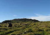
The Galgenberg (Gallows Hill), is believed to date from the Late Neolithic or early Bronze Age, and stands on a crossing point of ancient routes through the sandy Hondsrug region of Drenthe just over a kilometre to the west of the town of Annen. Although this burial mound is not particularly high, it was very much a landmark for traffic crossing this level terrain. The single large stone on its crest is one of the very few old mediaeval boundary markers that remains today. Until 1900, when the region was planted with trees, this was an area of open heathland.
During the Middle Ages, a gallows was set up on this burial mound (hence its name) and the bodies of those hanged were displayed as a warning to travellers.
You may be viewing yesterday's version of this page. To see the most up to date information please register for a free account.
")
")
")
Do not use the above information on other web sites or publications without permission of the contributor.
Nearby Images from Flickr


The above images may not be of the site on this page, but were taken nearby. They are loaded from Flickr so please click on them for image credits.
Click here to see more info for this site
Nearby sites
Click here to view sites on an interactive map of the areaKey: Red: member's photo, Blue: 3rd party photo, Yellow: other image, Green: no photo - please go there and take one, Grey: site destroyed
Download sites to:
KML (Google Earth)
GPX (GPS waypoints)
CSV (Garmin/Navman)
CSV (Excel)
To unlock full downloads you need to sign up as a Contributory Member. Otherwise downloads are limited to 50 sites.
Turn off the page maps and other distractions
Nearby sites listing. In the following links * = Image available
218m ESE 117° D8 Kniphorstbos* Passage Grave
282m SE 127° D8a Kniphorstbos* Passage Grave
304m SE 124° D8b Kniphorstbos* Passage Grave
351m N 356° Grafheuvel Driemarkenpunt Round Barrow(s)
798m W 273° D7 Kniphorstbos* Passage Grave
1.3km E 86° D9 Annen* Passage Grave
1.8km N 351° Grafheuvel Zuidlaren (46190) Round Barrow(s)
2.3km SSE 152° Grafheuvel Annen (45012)* Round Barrow(s)
2.7km SSE 163° Grafheuvels Annen (45013)* Round Barrow(s)
2.9km WSW 238° Grafheuvel Gasteren (45014) Round Barrow(s)
3.3km SW 232° D10 Gasteren* Passage Grave
3.5km SSW 204° Grafheuvel Gasteren (45016) Round Barrow(s)
3.5km SSE 167° D11 Anloo* Passage Grave
3.6km SSE 166° Grafheuvel Anloo* Round Barrow(s)
3.9km SSE 150° Grafheuvel Eext (45020)* Round Barrow(s)
4.2km SSE 148° Grafheuvel Eext (45021)* Round Barrow(s)
4.6km SE 133° Grafheuvel Eext (45033) Round Barrow(s)
4.7km WNW 289° D6 Tynaarlo* Passage Grave
5.1km SSE 162° Grafheuvel Eext (45023) Round Barrow(s)
5.2km S 173° Grafheuvel Eext (45022) Round Barrow(s)
5.4km NNW 329° Grafheuvels Midlaren (45399) Round Barrow(s)
5.4km SSE 151° Zwerfsteen Eext* Natural Stone / Erratic / Other Natural Feature
5.4km SSE 160° D12 Eext* Passage Grave
5.5km NNW 343° D4 Midlaren* Passage Grave
5.5km NNW 342° D3 Midlaren* Passage Grave
View more nearby sites and additional images


 We would like to know more about this location. Please feel free to add a brief description and any relevant information in your own language.
 Wir möchten mehr über diese Stätte erfahren. Bitte zögern Sie nicht, eine kurze Beschreibung und relevante Informationen in Deutsch hinzuzufügen.
 Nous aimerions en savoir encore un peu sur les lieux. S'il vous plaît n'hesitez pas à ajouter une courte description et tous les renseignements pertinents dans votre propre langue.
 Quisieramos informarnos un poco más de las lugares. No dude en añadir una breve descripción y otros datos relevantes en su propio idioma.