Featured: Explore Scotland (and everywhere else) with our Megalithic Portal iPhone app

Explore Scotland (and everywhere else) with our Megalithic Portal iPhone app

Random Image


Hell Gap

Stonehenge Tea Towels - Worldwide delivery

 Stonehenge Tea Towels - Worldwide delivery

Who's Online

There are currently, 432 guests and 0 members online.

You are a guest. To join in, please register for free by clicking here

Sponsors

<< Our Photo Pages >> Leskernick Hill Settlement - Ancient Village or Settlement in England in Cornwall

Submitted by TheCaptain on Wednesday, 14 June 2017  Page Views: 9358

Neolithic and Bronze AgeSite Name: Leskernick Hill Settlement
Country: England County: Cornwall Type: Ancient Village or Settlement
Nearest Town: Launceston  Nearest Village: Bolventor
Map Ref: SX18358000
Latitude: 50.591396N  Longitude: 4.567705W
Condition:
5Perfect
4Almost Perfect
3Reasonable but with some damage
2Ruined but still recognisable as an ancient site
1Pretty much destroyed, possibly visible as crop marks
0No data.
-1Completely destroyed
4 Ambience:
5Superb
4Good
3Ordinary
2Not Good
1Awful
0No data.
4 Access:
5Can be driven to, probably with disabled access
4Short walk on a footpath
3Requiring a bit more of a walk
2A long walk
1In the middle of nowhere, a nightmare to find
0No data.
2 Accuracy:
5co-ordinates taken by GPS or official recorded co-ordinates
4co-ordinates scaled from a detailed map
3co-ordinates scaled from a bad map
2co-ordinates of the nearest village
1co-ordinates of the nearest town
0no data
5

Internal Links:
External Links:

I have visited· I would like to visit

Vandora would like to visit

TheCaptain has visited here

Leskernick Hill Settlement
Leskernick Hill Settlement submitted by dodomad : ...a series of tests were undertaken using different parameters from both viewing areas, where the participants were asked to count the number of houses they thought they could see without augmentation, with augmentation using small white spheres, and finally with fully rendered Bronze Age house reconstructions being augmented via the iPad screen, sized to fit the traces of the houses on the groun... (Vote or comment on this photo)
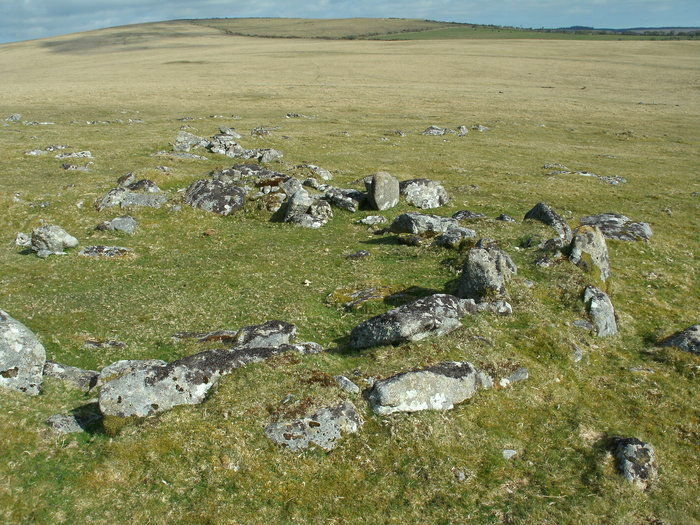
Remains of a well defined settlement can be seen on the southern slopes of Leskernick Hill, on the eastern side of Bodmin Moor, where the remains of several dozen huts can be found amongst the walls of small holdings and enclosures.

There are also several cairns, some with kerbs and cists.

Note: Exploring multi-sensory archaeological landscapes - virtual reality roundhouses at Leskernick Settlement, a kind of experimental location-based 'smellyvision' at Moesgård Museum and lots more digital creativity in the latest issue of Internet Archaeology, see the comments on our page
You may be viewing yesterday's version of this page. To see the most up to date information please register for a free account.


Leskernick Hill Settlement
Leskernick Hill Settlement submitted by Bladup : A hut circle at Leskernick Hill Settlement. (Vote or comment on this photo)

Leskernick Hill Settlement
Leskernick Hill Settlement submitted by theCaptain : Enjoying a pleasure flight in an old DH89 Rapide biplane, the settlement on the slopes of Leskernick Hill was clearly visible from my side of the aeroplane. (Vote or comment on this photo)

Leskernick Hill Settlement
Leskernick Hill Settlement submitted by Bladup : The cairn on top of the hill at Leskernick Hill Settlement. (Vote or comment on this photo)

Leskernick Hill Settlement
Leskernick Hill Settlement submitted by Bladup : A hut circle at Leskernick Hill Settlement. (Vote or comment on this photo)

Leskernick Hill Settlement
Leskernick Hill Settlement submitted by theCaptain : Enjoying a pleasure flight in an old DH89 Rapide biplane, this is a fine view of the north western hills of Bodmin Moor. Unfortunately in the shadow, the settlement on Leskernick Hill was clearly visible.

Leskernick Hill Settlement
Leskernick Hill Settlement submitted by theCaptain : Enjoying a pleasure flight in an old DH89 Rapide biplane, the settlement on the slopes of Leskernick Hill was clearly visible from my side of the aeroplane.

Leskernick Hill Settlement
Leskernick Hill Settlement submitted by thecaptain : Leskernick Hill with its well preserved ancient settlement.

Leskernick Hill Settlement
Leskernick Hill Settlement submitted by thecaptain : Some of the complex field wall arrangements at the lower edges of this well preserved ancient settlement.

Leskernick Hill Settlement
Leskernick Hill Settlement submitted by thecaptain : I had no time to explore this well preserved ancient settlement, but walked up to the lower walling for a quick look.

Leskernick Hill Settlement
Leskernick Hill Settlement submitted by thecaptain

Do not use the above information on other web sites or publications without permission of the contributor.
Click here to see more info for this site

Nearby sites

Click here to view sites on an interactive OS map

Key: Red: member's photo, Blue: 3rd party photo, Yellow: other image, Green: no photo - please go there and take one, Grey: site destroyed

Download sites to:
KML (Google Earth)
GPX (GPS waypoints)
CSV (Garmin/Navman)
CSV (Excel)

To unlock full downloads you need to sign up as a Contributory Member. Otherwise downloads are limited to 50 sites.


Turn off the page maps and other distractions

Nearby sites listing. In the following links * = Image available
 135m NNW 335° Leskernick 2* Natural Stone / Erratic / Other Natural Feature (SX1829880125)
 177m SSW 194° Leskernick cist* Cist (SX18307983)
 214m NNW 339° Leskernick Quoit* Natural Stone / Erratic / Other Natural Feature (SX1827980202)
 243m ESE 107° Leskernick NW* Stone Circle (SX18587992)
 351m N 353° Leskernick Hill cairn* Cairn (SX18328035)
 375m ESE 117° Leskernick cairn* Cairn (SX18687982)
 411m ESE 117° Leskernick* Ancient Village or Settlement (SX18717980)
 511m E 101° Leskernick Hill Row* Stone Row / Alignment (SX1884979885)
 591m SE 126° Leskernick SE* Stone Circle (SX18827964)
 1.1km NE 47° Westmoor Cairns* Cairn (SX19178070)
 1.2km SSE 154° Trezelland stone setting* Standing Stones (SX18857889)
 1.4km ESE 111° The Beacon Cist* Cist (SX19667944)
 1.5km ESE 117° The Beacon Cairns* Cairn (SX19677928)
 1.5km SE 126° Elephant Rock* Natural Stone / Erratic / Other Natural Feature (SX19557905)
 1.8km SW 216° Catshole Quoit* Chambered Tomb (SX17227856)
 1.9km NE 53° West Moor Possible Menhir* Standing Stone (Menhir) (SX1987081077)
 1.9km NNW 330° Buttern Hill Cairns* Cairn (SX17478167)
 2.0km ENE 67° Westmoorgate circle* Stone Circle (SX20258073)
 2.0km ENE 63° Westmoorgate cairn* Cairn (SX2020680866)
 2.1km SSW 212° Catshole Downs long cairn* Chambered Cairn (SX172783)
 2.2km NW 318° Buttern Hill row* Stone Row / Alignment (SX1695681658)
 2.2km NNE 12° Bray Down Cairns* Cairn (SX18908216)
 2.3km SSW 200° Tolborough Tor Cairn* Cairn (SX175779)
 2.3km S 185° Tolborough Standing Stone* Standing Stone (Menhir) (SX1807877741)
 2.3km SSW 199° Tolborough Tor stone row* Stone Row / Alignment (SX17547787)
View more nearby sites and additional images

<< Craw Stane

Mannu Nuraghe (Ozieri) >>

Please add your thoughts on this site

Cornwall in Prehistory

Cornwall in Prehistory

Sponsors

Auto-Translation (Google)

Translate from English into:

"Leskernick Hill Settlement" | Login/Create an Account | 13 News and Comments
  
Go back to top of page    Comments are owned by the poster. We aren't responsible for their content.
Exploring embodied GIS with an iPad at Leskernick Hill Settlement by Andy B on Tuesday, 06 June 2017
(User Info | Send a Message)
Stuart Eve writes: I present an application of embodied GIS undertaken within the Bronze Age landscape of Leskernick Hill, Bodmin Moor, Cornwall. [Geographical Information System, or 'database with map interface' - in this case one you can carry round on an iPad- MegP Ed] Leskernick Hill nestles in the north-eastern part of Bodmin Moor in Cornwall. It is an unimposing hill, dwarfed, overlooked and virtually enclosed by a ring of surrounding hills.

The advent of the Neolithic and Early Bronze Age in the UK brought the construction of various different types of ritual or ceremonial monuments, including long cairns, stone rows, stone circles and hill-top enclosures, many of which are found on Bodmin Moor and Leskernick Hill. As the late Neolithic transitions into the Bronze Age, we also begin to find widespread evidence of permanent and substantial domestic settlement areas, enclosures, fields and cultivation of the land.

As part of previous research, I undertook a formal experiment to investigate the effectiveness of using visual augmentation in the embodied GIS to provide a feeling of presence in the landscape and to assess whether the embodied GIS helps in identifying the location, size and shape of the Bronze Age houses. The experiment is explored in full elsewhere (Leskernick Hill Settlement - A house with a view? - Eve 2014 - see link below).

A 'traditional' GIS model of the hill was created, with two viewing areas specified. These locations were chosen as they have different perspectives on the rest of the settlement. House 50 stands slightly apart and has a view up a slope to the rest of the houses. House 35 is part of a cluster of houses, and was chosen to explore the feeling of being deep within the settlement. A series of tests were undertaken using different parameters from both viewing areas, where the participants were asked to count the number of houses they thought they could see without augmentation, with augmentation using small white spheres, and finally with fully rendered Bronze Age house reconstructions being augmented via the iPad screen, sized to fit the traces of the houses on the ground.

More at
http://intarch.ac.uk/journal/issue44/3/4-1.html
An extract from The Embodied GIS. Using Mixed Reality to explore multi-sensory archaeological landscapes - Stuart Eve

Lots more Digital Creativity in the latest issue of Internet Archaeology.
[ Reply to This ]
    Re: Exploring embodied GIS with an iPad at Leskernick Hill Settlement by TheCaptain on Tuesday, 06 June 2017
    (User Info | Send a Message)
    For those that don't know, which includes me, Googling GIS gives the following.
    "A geographic information system (GIS) is a system designed to capture, store, manipulate, analyze, manage, and present spatial or geographic data"
    So I am still none the wiser!
    [ Reply to This ]
      Re: Exploring embodied GIS with an iPad at Leskernick Hill Settlement by Andy B on Wednesday, 14 June 2017
      (User Info | Send a Message)
      Fancy name for a database with a map interface, like any of the county HERs (Historic Environment Record). The particular thing you can do with a GIS is it can hold shapes of things rather than just point locations, so you can see things like the location and shape of the scheduled area of a monument, as the MAGIC map used to (must find out what the link to that is now). Or in the case of the above research, the shape and location of 'pretend' 3D roundhouses.
      [ Reply to This ]

Leskernick Hill Settlement - A house with a view? by Andy B on Thursday, 25 May 2017
(User Info | Send a Message)
A house with a view? Multi-model inference, visibility fields, and point process analysis of a Bronze Age settlement on Leskernick Hill - Stuart J. Eve, Enrico R. Crema, 2014

https://doi.org/10.1016/j.jas.2013.12.019

Open Access, funded by Arts and Humanities Research Council
http://discovery.ucl.ac.uk/1419127/1/1-s2.0-S0305440314000028-main.pdf
[ Reply to This ]

Stone Worlds: narrative and reflexivity in landscape archaeology by Andy B on Sunday, 19 January 2014
(User Info | Send a Message)
Stone Worlds: narrative and reflexivity in landscape archaeology. Barbara Bender, Sue Hamilton and Chris Tilley, with Ed Anderson, Stephan Harrison, Peter Herring, Martyn Waller, Tony Williams and Mike Wilmore.

Stone Worlds documents an experimental, collaborative field project at Leskernick, a small hill on Bodmin Moor in northern Cornwall. The project was directed by two social anthropologists with interests in archaeology (Barbara Bender and Chris Tilley) and an archaeologist (Sue Hamilton), all of whom are based at University College London. The book is co-authored by these directors in partnership with six further named authors, and is punctuated by many other voices, drawn mainly from the excavation team. This unusual format derives from the book’s main purpose: to attempt to deliver a multivocal account of an archaeological project, which is concerned more with interpretive process, narrative and reflexivity than with outcome.

...They conclude that ‘the people of Leskernick Hill regarded the stones as animate sentient beings, the very opposite of a modernist belief system in which the stones are regarded as inanimate objects to be exploited at will’

This last contention hints at the least satisfactory element of the book. The authors adopt a hyper-interpretive approach, based on the belief that ‘although there is a “real” world out there, we can only access it through our concepts, words, and metaphors’ (p. 26). This combines with a form of New Age romanticism for the prehistoric past. The constant breaking-up of the text with diary entries, snatches of conversation or personal reflections, the poems about the stones, the phenomenological photo-essay about ‘moving in procession’ across the landscape, and the descriptions of ‘offerings of joss sticks and a corn sheaf… on the eve of the summer solstice’ at a large stone named by the excavators ‘the Shrine Stone’ (p. 203), combine to produce the disconcerting feeling of listening to a progressive rock concept album, rather than reading a book about Cornish prehistory and heritage.

Book review by Dan Hicks
http://profdanhicks.blogspot.co.uk/2009/08/stone-worlds.html
[ Reply to This ]
    Re: Stone Worlds: narrative and reflexivity in landscape archaeology by tiompan on Monday, 20 January 2014
    (User Info | Send a Message)


    Dan Hicks sounds like a good bloke .
    [ Reply to This ]
    Re: Stone Worlds: narrative and reflexivity in landscape archaeology by Andy B on Thursday, 25 May 2017
    (User Info | Send a Message)
    Another review of Stone Worlds: Narrative and Reflexivity in Landscape
    Archaeology, by Barbara Bender, Sue Hamilton & Chris Tilley, 2007

    Stone Worlds is an overview, perhaps even a popular account, of a series of surveys, excavations, studies and activities carried out between 1995 and 1999 by an extensive multi-disciplinary team whose geographical focus was the stark stony uplands of Leskernick Hill on Bodmin Moor in southwest England.

    Reivew by Tim Darvill

    http://eprints.bournemouth.ac.uk/11826/1/Stone_Worlds.pdf
    [ Reply to This ]
    Re: Stone Worlds: narrative and reflexivity in landscape archaeology by Andy B on Wednesday, 29 November 2017
    (User Info | Send a Message)
    NARRATIVE AROUND THE SHAMAN'S HOUSE (Hut No. 3)
    Christopher Tilley

    House No 3 is one of the two most isolated houses on Leskernick hill, the other being house 28 in the corridor. Situated far to the north of the western settlement area and highest up the hill it is the only house whose doorway is directly orientated so as to face the Rough Tor summit in the distance. Especially in misty or cloudy weather Rough Tor appears to float on the horizon line, sometimes visible, sometimes not. Its exact position is difficult to determine from here. Although forming the hill to the north-west of High Moor it sometimes appears to be a tor on the latter. Like house 28 it is located in the middle of a particularly dense area of clitter.

    There is a particularly dense clitter mass with large grounders 10 m to the north and the Leskernick mini tor with its surrounding clitter masses is 10 m to the south. The back of the house is aligned due north with the back of the tor. House 3 is 35 m due west of the Quoit and closer to it than any other house on the hill. To its east and immediately above the house is an irregular shaped area enclosed by low walls linking grounders which is virtually free of stone with a maximum width of 20 m north-south and 15 m west-east. About 7 m south-west of the house there is a small cairn set in amongst the clitter on the edge of an oval shaped clearing in front of and to the west of the mini tor.

    This clearing is up to 15 m wide and has a maximal length of 45 m to the edge of the dense clitter mass down-slope to the west. It forms a theatrical arena directly beneath the tor and to the south of the Shaman's hut. The tor consists of an exposed rock outcrop about 2 m high on top of which a large block has been placed and/or swivelled round to point towards the north-west. This block is 3 m long, 1.10 m wide and 0.9 m high. The mini tor appears to be set within a facade of large, thin slab-like stones which run up to it from below on the northern side and southern sides and around its back or eastern side.

    Whether or not any of these stones have been placed, moved, wedged or propped up they create a facade-like effect serving to frame or emphasise the tor itself when seen from the cleared space below it. A low and indistinct wall, linking many grounders runs away to the south-west of the tor linking it to a shrine structure just to the north of the perimeter wall of the main western compound about 30 m distant. This consists of a large square shaped grounder about 3 m wide and 0.5 m high. On top of the eastern part of this grounder there are two large and irregular perched boulders. Beside it on the western side there are three large blocks resting against the edge of the grounder. It appears as if these have been displaced from their original positions propped up on top of the grounder with the two stones on top of it providing the necessary support to hold them upright.

    There are a series of other clitter structures in the clitter below the mini tor and its cleared space. At the head of the clitter mass, up-slope at its eastern end there appears to be a facade of thin slab-like stones like those running up to the mini tor. Below these there are two or more indistinct circular structures in which grounders appear to be encircled or partly surrounded, in an arc, by other stones. One of these has been later re-worked as a millstone but no attempt has been made to remove it from the clitter mass.

    http://www.ucl.ac.uk/leskernick/articles/narrative/text/shaman.htm
    [ Reply to This ]

The Leskernick Project by Andy B on Tuesday, 10 December 2013
(User Info | Send a Message)
The Leskernick Project was a multidisciplinary approach to landscape and the symbolism of place on Bodmin Moor, eastern Cornwall. The project ran from 1995 until 1999. It is was directed by Barbara Bender, Sue Hamilton and Christopher Tilley of the Department of Anthropology and Institute of Archaeology, University College London.

Leskernick Project Articles
Art and the Re-presentation of the Past
Barbara Bender, Sue Hamilton, Christopher Tilley

Stone Worlds, Alternative Narratives, Nested Landscapes
Barbara Bender, Sue Hamilton, Christopher Tilley

Nature, Culture, Clitter
distinguishing between cultural and geomorphological landscapes Christopher Tilley, Sue Hamilton, Stephan Harrison, Ed Anderson

Leskernick Narratives

http://www.ucl.ac.uk/leskernick/articles.html
[ Reply to This ]
    Leskernick Project early presence on the web by Andy B on Friday, 17 November 2017
    (User Info | Send a Message)
    Interestingly - for archaeologists of the Internet anyhow - is that Leskernick seems to have been the first British excavation that had its own web diaries published, starting back in 1996!
    http://www.ucl.ac.uk/leskernick/diaries.html

    There was also an email list which I've just discovered 20 years too late, on which there were discussions of various things such as how to handle increased visitor numbers - see the link 'Visitors' here:
    http://www.ucl.ac.uk/leskernick/forum.html

    Their web pages are a veritable time capsule of the web of 1996, when frames were the latest cutting edge thing in web design and it seems JPG images hadn't been invented, as all their images are GIFs - remarkable in its longevity this one: http://www.ucl.ac.uk/leskernick/home.htm
    [ Reply to This ]
    Re: The Leskernick Project by Andy B on Wednesday, 29 November 2017
    (User Info | Send a Message)
    WALKING THE NORTHERN WALL by Barbara Bender

    Close to the top of the hill is the quoit. In prehistoric times people lifted one stone on top of the other, and then levered up the top stone and propped it so that a peep-hole was created. On the evening of the Summer Solstice, if you stand to the south of the quoit, the sun goes down behind the peep-hole.

    Just south of the quoit we found the remains of a small stone circle. Very ruined. But from it runs a line of stones, and this line is directly aligned on the quoit.

    Below the quoit, again to the south and downslope, you can see the large pyramid stone. It lies at the top of the corridor that runs up the hill between the southern and western settlements.

    There is a wall, a strange wall, that runs north and south and west of the quoit. It runs south from the quoit to the north-east corner of the western compound, it runs north from the quoit to an important tabular stone outcrop and then circles west down to the Fowey valley. There is also a short remnant of wall to the west of the quoit which comes up against the compound behind the shaman’s house (house 3). This wall is not big enough or compact enough to keep out animals. Its purpose, we think, is to ‘contain’ the western settlement. It marks the edge of the everyday world and links that world to the high places where more formal rituals took place.

    Henry and Barbara walked the length of the wall. They started above the river Fowey and followed the wall as ran up the hill towards the tabular outcrop.

    http://www.ucl.ac.uk/leskernick/articles/narrative/wall.htm
    [ Reply to This ]
    Distinguishing between cultural and geomorphological landscapes; hilltop tors by Andy B on Wednesday, 29 November 2017
    (User Info | Send a Message)
    NATURE, CULTURE, CLITTER - distinguishing between cultural and geomorphological landscapes; the case of hilltop tors in south-west England

    Christopher Tilley, Sue Hamilton, Stephan Harrison, Ed Anderson

    This article addresses the problem of how to distinguish between natural and humanly modified features of the cultural landscape with reference to clitter (boulder and stone) masses in the south-west of England using the example of Leskernick hill, Bodmin Moor with its well-preserved Bronze Age settlement. We first set out a series of criteria for distinguishing between natural and humanly placed stones on the basis of a series of formal geomorphological criteria. We then discuss the stones from an archaeological perspective setting out a series of archaeological criteria by means of which we can recognise the presence of humanly modified stones.

    From this basis we discuss four examples in detail. Finally we attempt to interpret the significance of the cultural modification of stone masses, previously regarded by both archaeologists and geomorphologists as being entirely natural in origin, by challenging the very culture/nature distinction for ascribing meaning on which the previous considerations are made. Whilst acknowledging that the distinction between a stone that has been moved by human agency, and one that has not, is important for interpretation this does not make it more or less culturally significant.

    http://www.ucl.ac.uk/leskernick/articles/clitter/clitter.htm
    [ Reply to This ]

Re: Leskernick Hill Settlement by MikeAitch on Saturday, 11 October 2008
(User Info | Send a Message)
I hope to visit soon Google sat image shows the settlement very well
[ Reply to This ]

Your Name: Anonymous [ Register Now ]
Subject:


Add your comment or contribution to this page. Spam or offensive posts are deleted immediately, don't even bother

<<< What is five plus one as a number? (Please type the answer to this question in the little box on the left)
You can also embed videos and other things. For Youtube please copy and paste the 'embed code'.
For Google Street View please include Street View in the text.
Create a web link like this: <a href="https://www.megalithic.co.uk">This is a link</a>  

Allowed HTML is:
<p> <b> <i> <a> <img> <em> <br> <strong> <blockquote> <tt> <li> <ol> <ul> <object> <param> <embed> <iframe>

We would like to know more about this location. Please feel free to add a brief description and any relevant information in your own language.
Wir möchten mehr über diese Stätte erfahren. Bitte zögern Sie nicht, eine kurze Beschreibung und relevante Informationen in Deutsch hinzuzufügen.
Nous aimerions en savoir encore un peu sur les lieux. S'il vous plaît n'hesitez pas à ajouter une courte description et tous les renseignements pertinents dans votre propre langue.
Quisieramos informarnos un poco más de las lugares. No dude en añadir una breve descripción y otros datos relevantes en su propio idioma.