


<< Our Photo Pages >> Woodwell - Holy Well or Sacred Spring in England in Lancashire
Submitted by Wellspirit on Sunday, 09 September 2007 Page Views: 13017
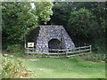
Springs and Holy WellsSite Name: WoodwellCountry: England County: Lancashire Type: Holy Well or Sacred Spring
Nearest Village: Silverdale
Map Ref: SD4674
Latitude: 54.158956N Longitude: 2.828439W
Condition:
| 5 | Perfect |
| 4 | Almost Perfect |
| 3 | Reasonable but with some damage |
| 2 | Ruined but still recognisable as an ancient site |
| 1 | Pretty much destroyed, possibly visible as crop marks |
| 0 | No data. |
| -1 | Completely destroyed |
| 5 | Superb |
| 4 | Good |
| 3 | Ordinary |
| 2 | Not Good |
| 1 | Awful |
| 0 | No data. |
| 5 | Can be driven to, probably with disabled access |
| 4 | Short walk on a footpath |
| 3 | Requiring a bit more of a walk |
| 2 | A long walk |
| 1 | In the middle of nowhere, a nightmare to find |
| 0 | No data. |
| 5 | co-ordinates taken by GPS or official recorded co-ordinates |
| 4 | co-ordinates scaled from a detailed map |
| 3 | co-ordinates scaled from a bad map |
| 2 | co-ordinates of the nearest village |
| 1 | co-ordinates of the nearest town |
| 0 | no data |
Internal Links:
External Links:
I have visited· I would like to visit
MicheleW visited on 1st Jan 2017 - their rating: Cond: 3 Amb: 4 Access: 5
FrothNinja visited - their rating: Access: 5
Average ratings for this site from all visit loggers: Access: 5
")
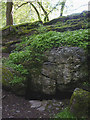
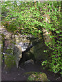
A beautiful well with water issuing from a rockface and into a basin. It then flows into a large square pool originally used to water cattle.
Yew and other trees growing above the rockface and the area is surrounded by trees and woodland. Other small basins to left of the well, the specific use of which I do not know. I feel it is a very spiritual place. Several other wells in the area (an AONB).
You may be viewing yesterday's version of this page. To see the most up to date information please register for a free account.
")
Do not use the above information on other web sites or publications without permission of the contributor.
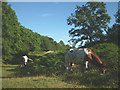
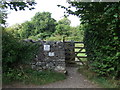
Nearby Images from Geograph Britain and Ireland:
©2014(licence)
©2015(licence)
©2015(licence)
©2015(licence)
©2015(licence)
The above images may not be of the site on this page, they are loaded from Geograph.
Please Submit an Image of this site or go out and take one for us!
Click here to see more info for this site
Nearby sites
Key: Red: member's photo, Blue: 3rd party photo, Yellow: other image, Green: no photo - please go there and take one, Grey: site destroyed
Download sites to:
KML (Google Earth)
GPX (GPS waypoints)
CSV (Garmin/Navman)
CSV (Excel)
To unlock full downloads you need to sign up as a Contributory Member. Otherwise downloads are limited to 50 sites.
Turn off the page maps and other distractions
Nearby sites listing. In the following links * = Image available
2.1km ESE 117° Ings Point Natural Stone / Erratic / Other Natural Feature (SD479730)
2.5km ESE 117° Badger Hole (Lancashire)* Cave or Rock Shelter (SD48187285)
2.5km ESE 112° Dog Holes* Cave or Rock Shelter (SD48337303)
3.0km SE 133° Cote Stones Cairn (SD482719)
3.1km NNE 28° Bowk Stone Natural Stone / Erratic / Other Natural Feature (SD475767)
3.4km ESE 111° Warton Crag* Hillfort (SD492727)
3.5km NNE 32° Haweswater Cairns and Propped Stone Cairn (SD479769)
3.5km NNE 30° Haweswater Stones* Misc. Earthwork (SD478770)
3.5km E 97° The Three brothers* Natural Stone / Erratic / Other Natural Feature (SD495735)
4.0km ESE 102° Warton Crag giant wall Misc. Earthwork (SD499731)
4.0km E 84° Summerhouse Hill* Modern Stone Circle etc (SD50037437)
4.1km E 85° Summerhouse Hill Cairn* Cairn (SD50147428)
4.2km NNW 340° Grubbins Wood Stone Natural Stone / Erratic / Other Natural Feature (SD446780)
4.5km NNE 16° Hazelslack Stone* Standing Stone (Menhir) (SD473783)
4.5km SE 137° Hunting Hill* Round Barrow(s) (SD49037065)
5.4km E 83° Yealand ancient stone walls or rows 1 Misc. Earthwork (SD514746)
5.4km ENE 76° Yealand ancient stone walls or rows 2 Misc. Earthwork (SD513753)
5.7km NNE 29° The Fairy Steps* Natural Stone / Erratic / Other Natural Feature (SD488790)
6.4km NE 35° The Rent Stone* Natural Stone / Erratic / Other Natural Feature (SD498792)
6.4km NNE 18° Dog Hole possible dolmen/propped stone* Natural Stone / Erratic / Other Natural Feature (SD481801)
6.5km E 100° Manor Farm* Round Barrow(s) (SD52387285)
6.5km NNE 19° The Dog Hole Cave or Rock Shelter (SD482801)
6.5km NNE 17° Haverbrack Cairn Cairn (SD480802)
6.6km SSE 159° St Michael's Well (Lancashire) Holy Well or Sacred Spring (SD4828567831)
6.8km SSE 159° Bolton Le Sands Early Christian Sculptured Stone (SD48336765)
View more nearby sites and additional images


 We would like to know more about this location. Please feel free to add a brief description and any relevant information in your own language.
 Wir möchten mehr über diese Stätte erfahren. Bitte zögern Sie nicht, eine kurze Beschreibung und relevante Informationen in Deutsch hinzuzufügen.
 Nous aimerions en savoir encore un peu sur les lieux. S'il vous plaît n'hesitez pas à ajouter une courte description et tous les renseignements pertinents dans votre propre langue.
 Quisieramos informarnos un poco más de las lugares. No dude en añadir una breve descripción y otros datos relevantes en su propio idioma.