


<< Our Photo Pages >> Stoney Raise - Cairn in England in Yorkshire (North)
Submitted by rich32 on Wednesday, 18 January 2006 Page Views: 7512
Neolithic and Bronze AgeSite Name: Stoney Raise Alternative Name: Stony RaiseCountry: England County: Yorkshire (North) Type: Cairn
Nearest Village: Bainbrisge
Map Ref: SD95068691
Latitude: 54.277808N Longitude: 2.077368W
Condition:
| 5 | Perfect |
| 4 | Almost Perfect |
| 3 | Reasonable but with some damage |
| 2 | Ruined but still recognisable as an ancient site |
| 1 | Pretty much destroyed, possibly visible as crop marks |
| 0 | No data. |
| -1 | Completely destroyed |
| 5 | Superb |
| 4 | Good |
| 3 | Ordinary |
| 2 | Not Good |
| 1 | Awful |
| 0 | No data. |
| 5 | Can be driven to, probably with disabled access |
| 4 | Short walk on a footpath |
| 3 | Requiring a bit more of a walk |
| 2 | A long walk |
| 1 | In the middle of nowhere, a nightmare to find |
| 0 | No data. |
| 5 | co-ordinates taken by GPS or official recorded co-ordinates |
| 4 | co-ordinates scaled from a detailed map |
| 3 | co-ordinates scaled from a bad map |
| 2 | co-ordinates of the nearest village |
| 1 | co-ordinates of the nearest town |
| 0 | no data |
Internal Links:
External Links:
")
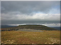
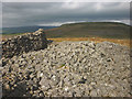
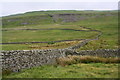
This giant cairn is located on Greenber Edge, nr Bainbridge, North Yorkshire.
Thought to be the largest cairn in the Yorkshire Dales, it measures 34.5 meters in diameter & still stands proudly to a height of 2.4 meters. Although much reduced by heavy stone robbing & some early excavations, it still remains a magnificent site.
50 meters to the east is an early mediaeval settlement.
You may be viewing yesterday's version of this page. To see the most up to date information please register for a free account.
")
")
Do not use the above information on other web sites or publications without permission of the contributor.
Nearby Images from Geograph Britain and Ireland:
©2018(licence)
©2018(licence)
©2007(licence)
©2007(licence)
©2018(licence)
The above images may not be of the site on this page, they are loaded from Geograph.
Please Submit an Image of this site or go out and take one for us!
Click here to see more info for this site
Nearby sites
Key: Red: member's photo, Blue: 3rd party photo, Yellow: other image, Green: no photo - please go there and take one, Grey: site destroyed
Download sites to:
KML (Google Earth)
GPX (GPS waypoints)
CSV (Garmin/Navman)
CSV (Excel)
To unlock full downloads you need to sign up as a Contributory Member. Otherwise downloads are limited to 50 sites.
Turn off the page maps and other distractions
Nearby sites listing. In the following links * = Image available
1.0km NNW 345° Addlebrough Cup-Marked Rock Rock Art (SD948879)
1.3km NNW 327° Devil's Stone (Bainbridge) Natural Stone / Erratic / Other Natural Feature (SD94358799)
1.3km NNW 339° Addlebrough* Cairn (SD94598812)
1.7km ENE 70° Dove Stones (Thornton Rust Moor) Rock Art (SD9663487493)
3.2km E 83° Castle Dykes* Henge (SD9823187289)
4.1km N 356° Askrigg Cross* Ancient Cross (SD9480591026)
5.1km NE 51° Carperby Stone Circle* Stone Circle (SD99009013)
6.2km ENE 63° Carperby Cross* Ancient Cross (SE0063189729)
6.3km ENE 63° St Matthew's Well (Carperby)* Holy Well or Sacred Spring (SE0065689756)
8.1km E 96° Burton Moor* Ancient Village or Settlement (SE03118604)
9.1km SW 214° Yockenthwaite* Ring Cairn (SD8995779376)
10.0km WSW 250° Mêni Mabbin Stone Row / Alignment (SD856835)
11.1km NNW 339° Muker Stone Circle (SD911973)
11.7km SSE 162° Little Hunters Sleets Cairn Cairn (SD98647576)
11.8km SSE 165° Tor Dike Ancient Village or Settlement (SD98137551)
11.8km W 259° Old Wife's Spring (Snaizeholme) Holy Well or Sacred Spring (SD834847)
13.2km NNE 32° Maiden Castle (N Yorks)* Ancient Village or Settlement (SE02189808)
13.4km NNE 33° Maiden Castle Barrow (Yorkshire North) Round Barrow(s) (SE02349814)
13.6km NE 38° Harkerside Moor circle* Stone Circle (SE035976)
14.4km E 79° Holy Trinity (Wensley)* Ancient Cross (SE09228954)
16.0km S 186° Blue Scar (Arncliffe)* Ancient Village or Settlement (SD93237100)
16.5km SW 215° Giant's Graves (Halton Gill) Cairn (SD8564873346)
17.3km E 87° St Alkelda's Holy Well* Holy Well or Sacred Spring (SE124879)
17.5km E 87° St Mary and St Alkelda* Ancient Cross (SE1262887878)
17.6km E 81° Fairy Well (Harmby)* Holy Well or Sacred Spring (SE12448969)
View more nearby sites and additional images


 We would like to know more about this location. Please feel free to add a brief description and any relevant information in your own language.
 Wir möchten mehr über diese Stätte erfahren. Bitte zögern Sie nicht, eine kurze Beschreibung und relevante Informationen in Deutsch hinzuzufügen.
 Nous aimerions en savoir encore un peu sur les lieux. S'il vous plaît n'hesitez pas à ajouter une courte description et tous les renseignements pertinents dans votre propre langue.
 Quisieramos informarnos un poco más de las lugares. No dude en añadir una breve descripción y otros datos relevantes en su propio idioma.