

<< Our Photo Pages >> Addlebrough - Cairn in England in Yorkshire (North)
Submitted by rich32 on Friday, 09 September 2005 Page Views: 8431
Neolithic and Bronze AgeSite Name: AddlebroughCountry: England County: Yorkshire (North) Type: Cairn
Nearest Town: Richmond Nearest Village: Thornton Rust
Map Ref: SD94598812
Latitude: 54.288678N Longitude: 2.084608W
Condition:
| 5 | Perfect |
| 4 | Almost Perfect |
| 3 | Reasonable but with some damage |
| 2 | Ruined but still recognisable as an ancient site |
| 1 | Pretty much destroyed, possibly visible as crop marks |
| 0 | No data. |
| -1 | Completely destroyed |
| 5 | Superb |
| 4 | Good |
| 3 | Ordinary |
| 2 | Not Good |
| 1 | Awful |
| 0 | No data. |
| 5 | Can be driven to, probably with disabled access |
| 4 | Short walk on a footpath |
| 3 | Requiring a bit more of a walk |
| 2 | A long walk |
| 1 | In the middle of nowhere, a nightmare to find |
| 0 | No data. |
| 5 | co-ordinates taken by GPS or official recorded co-ordinates |
| 4 | co-ordinates scaled from a detailed map |
| 3 | co-ordinates scaled from a bad map |
| 2 | co-ordinates of the nearest village |
| 1 | co-ordinates of the nearest town |
| 0 | no data |
Internal Links:
External Links:
I have visited· I would like to visit
virtualsue visited on 1st May 2011 - their rating: Cond: 2 Amb: 5 Access: 3 We live in Aysgarth and have been up Addlebrough a number of times over the years. The setting and views are incredible. The cairn is barely recognisable at this point, though the cup marks are interesting, shame about the partial OS benchmark on the best cup marked slab. I have seen photos of the trig point that used to be on the cairn, which looks as though it was made from stone taken from the cairn itself.
")
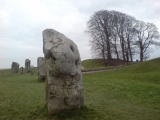
This cairn sits on the NW western edge of Addlebrough, which is a prominent hill SW of Aysgarth.
The cairn has almost been destroyed by stone robbing & the construction of a trig point (no longer extant) at its northern end. It has a diameter of 10.5m and reaches a height of roughly 60cm. Although the monument itself isn’t much to look at, its gradual destruction has exposed 3 cup marked rocks, 2 of which are quite impressive.
You may be viewing yesterday's version of this page. To see the most up to date information please register for a free account.
")
")
")
")
")
Do not use the above information on other web sites or publications without permission of the contributor.
Click here to see more info for this site
Nearby sites
Key: Red: member's photo, Blue: 3rd party photo, Yellow: other image, Green: no photo - please go there and take one, Grey: site destroyed
Download sites to:
KML (Google Earth)
GPX (GPS waypoints)
CSV (Garmin/Navman)
CSV (Excel)
To unlock full downloads you need to sign up as a Contributory Member. Otherwise downloads are limited to 50 sites.
Turn off the page maps and other distractions
Nearby sites listing. In the following links * = Image available
272m WSW 241° Devil's Stone (Bainbridge) Natural Stone / Erratic / Other Natural Feature (SD94358799)
304m SE 136° Addlebrough Cup-Marked Rock Rock Art (SD948879)
1.3km SSE 159° Stoney Raise* Cairn (SD95068691)
2.1km ESE 107° Dove Stones (Thornton Rust Moor) Rock Art (SD9663487493)
2.9km N 4° Askrigg Cross* Ancient Cross (SD9480591026)
3.7km ESE 103° Castle Dykes* Henge (SD9823187289)
4.8km ENE 65° Carperby Stone Circle* Stone Circle (SD99009013)
6.2km ENE 75° Carperby Cross* Ancient Cross (SE0063189729)
6.3km ENE 75° St Matthew's Well (Carperby)* Holy Well or Sacred Spring (SE0065689756)
8.7km ESE 104° Burton Moor* Ancient Village or Settlement (SE03118604)
9.8km NNW 339° Muker Stone Circle (SD911973)
9.9km SSW 208° Yockenthwaite* Ring Cairn (SD8995779376)
10.1km WSW 243° Mêni Mabbin Stone Row / Alignment (SD856835)
11.7km WSW 253° Old Wife's Spring (Snaizeholme) Holy Well or Sacred Spring (SD834847)
12.5km NE 37° Maiden Castle (N Yorks)* Ancient Village or Settlement (SE02189808)
12.6km NE 38° Maiden Castle Barrow (Yorkshire North) Round Barrow(s) (SE02349814)
13.0km NE 43° Harkerside Moor circle* Stone Circle (SE035976)
13.0km SSE 162° Little Hunters Sleets Cairn Cairn (SD98647576)
13.1km SSE 164° Tor Dike Ancient Village or Settlement (SD98137551)
14.7km E 84° Holy Trinity (Wensley)* Ancient Cross (SE09228954)
17.2km S 184° Blue Scar (Arncliffe)* Ancient Village or Settlement (SD93237100)
17.2km NE 44° Whitton Burn(Rock Art) Rock Art (NZ066005)
17.2km SSW 211° Giant's Graves (Halton Gill) Cairn (SD8564873346)
17.8km E 91° St Alkelda's Holy Well* Holy Well or Sacred Spring (SE124879)
17.9km E 85° Fairy Well (Harmby)* Holy Well or Sacred Spring (SE12448969)
View more nearby sites and additional images


 We would like to know more about this location. Please feel free to add a brief description and any relevant information in your own language.
 Wir möchten mehr über diese Stätte erfahren. Bitte zögern Sie nicht, eine kurze Beschreibung und relevante Informationen in Deutsch hinzuzufügen.
 Nous aimerions en savoir encore un peu sur les lieux. S'il vous plaît n'hesitez pas à ajouter une courte description et tous les renseignements pertinents dans votre propre langue.
 Quisieramos informarnos un poco más de las lugares. No dude en añadir una breve descripción y otros datos relevantes en su propio idioma.