 with our Megalithic Portal iPhone app")

<< Our Photo Pages >> Holý vrch II - Standing Stone (Menhir) in Czech Republic in Bohemia
Submitted by ladrin on Sunday, 17 March 2019 Page Views: 581
Neolithic and Bronze AgeSite Name: Holý vrch IICountry: Czech Republic
NOTE: This site is 24.445 km away from the location you searched for.
Region: Bohemia Type: Standing Stone (Menhir)
Nearest Town: Sedlec Prčice Nearest Village: Libenice
Latitude: 49.529789N Longitude: 14.561878E
Condition:
| 5 | Perfect |
| 4 | Almost Perfect |
| 3 | Reasonable but with some damage |
| 2 | Ruined but still recognisable as an ancient site |
| 1 | Pretty much destroyed, possibly visible as crop marks |
| 0 | No data. |
| -1 | Completely destroyed |
| 5 | Superb |
| 4 | Good |
| 3 | Ordinary |
| 2 | Not Good |
| 1 | Awful |
| 0 | No data. |
| 5 | Can be driven to, probably with disabled access |
| 4 | Short walk on a footpath |
| 3 | Requiring a bit more of a walk |
| 2 | A long walk |
| 1 | In the middle of nowhere, a nightmare to find |
| 0 | No data. |
| 5 | co-ordinates taken by GPS or official recorded co-ordinates |
| 4 | co-ordinates scaled from a detailed map |
| 3 | co-ordinates scaled from a bad map |
| 2 | co-ordinates of the nearest village |
| 1 | co-ordinates of the nearest town |
| 0 | no data |
Internal Links:
External Links:
")
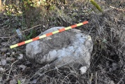
Next stone of the Holý vrch can be found about 50m NE from the "Holý vrch I" menhir. Quite inconspicuous piece of standing granite, hidden in the dense vegetation and in this time almost covered by the fallen tree.
You may be viewing yesterday's version of this page. To see the most up to date information please register for a free account.
")
Do not use the above information on other web sites or publications without permission of the contributor.
Nearby Images from Flickr


The above images may not be of the site on this page, but were taken nearby. They are loaded from Flickr so please click on them for image credits.
Click here to see more info for this site
Nearby sites
Click here to view sites on an interactive map of the areaKey: Red: member's photo, Blue: 3rd party photo, Yellow: other image, Green: no photo - please go there and take one, Grey: site destroyed
Download sites to:
KML (Google Earth)
GPX (GPS waypoints)
CSV (Garmin/Navman)
CSV (Excel)
To unlock full downloads you need to sign up as a Contributory Member. Otherwise downloads are limited to 50 sites.
Turn off the page maps and other distractions
Nearby sites listing. In the following links * = Image available
105m SSW 204° Holý vrch I* Standing Stones
5.5km SSW 209° Jistebnice stones* Standing Stones
5.6km WNW 290° Menhirs of Chlístov* Standing Stones
6.6km NW 313° Kamenný kruh Stuchanov* Modern Stone Circle etc
7.0km WNW 290° Veletín Menhir* Standing Stone (Menhir)
7.1km WNW 297° Buckovna stones* Standing Stones
7.2km W 275° Růžená II* Standing Stones
7.3km W 278° Růžená Menhir* Standing Stone (Menhir)
7.3km WNW 285° Zádvoří II* Standing Stone (Menhir)
7.3km WNW 285° Zádvoří 1* Standing Stone (Menhir)
7.3km WSW 245° Nadějkov stone cross* Ancient Cross
7.5km WNW 294° Sacrificial Stone Veletín* Natural Stone / Erratic / Other Natural Feature
7.7km WNW 296° Myslkov Dolmen* Natural Stone / Erratic / Other Natural Feature
7.9km WSW 247° Křesílko* Standing Stone (Menhir)
8.7km NW 311° Zvěřinec Menhir II.* Standing Stone (Menhir)
8.8km NW 309° Zvěřinec Menhir III* Standing Stone (Menhir)
9.0km NW 311° Zvěřinec Menhir I.* Standing Stone (Menhir)
9.0km NW 304° Celtic Seat* Standing Stone (Menhir)
9.7km WNW 286° Menhir na Homoli* Standing Stone (Menhir)
9.8km W 276° Kozlov 2 Menhir* Standing Stone (Menhir)
9.8km W 274° Kozlov 1 Menhir* Standing Stone (Menhir)
12.2km WNW 288° Ikarta Stone* Standing Stone (Menhir)
12.2km W 277° Králov Menhir* Standing Stone (Menhir)
14.0km WNW 303° Flying Saucer Dolmen* Natural Stone / Erratic / Other Natural Feature
14.1km SSW 213° Sepekov barrow cemetery* Barrow Cemetery
View more nearby sites and additional images


 We would like to know more about this location. Please feel free to add a brief description and any relevant information in your own language.
 Wir möchten mehr über diese Stätte erfahren. Bitte zögern Sie nicht, eine kurze Beschreibung und relevante Informationen in Deutsch hinzuzufügen.
 Nous aimerions en savoir encore un peu sur les lieux. S'il vous plaît n'hesitez pas à ajouter une courte description et tous les renseignements pertinents dans votre propre langue.
 Quisieramos informarnos un poco más de las lugares. No dude en añadir una breve descripción y otros datos relevantes en su propio idioma.