<< Our Photo Pages >> Hokori Kofun - Passage Grave in Japan in Honshū
Submitted by aska on Saturday, 18 April 2015 Page Views: 1437
Iron Age and Later PrehistorySite Name: Hokori Kofun Alternative Name: 保子里古墳Country: Japan
NOTE: This site is 4.504 km away from the location you searched for.
Region: Honshū Type: Passage Grave
Nearest Town: Suzuka (Mie pref.) Nearest Village: Kōchō 国府町
Latitude: 34.858770N Longitude: 136.495070E
Condition:
| 5 | Perfect |
| 4 | Almost Perfect |
| 3 | Reasonable but with some damage |
| 2 | Ruined but still recognisable as an ancient site |
| 1 | Pretty much destroyed, possibly visible as crop marks |
| 0 | No data. |
| -1 | Completely destroyed |
| 5 | Superb |
| 4 | Good |
| 3 | Ordinary |
| 2 | Not Good |
| 1 | Awful |
| 0 | No data. |
| 5 | Can be driven to, probably with disabled access |
| 4 | Short walk on a footpath |
| 3 | Requiring a bit more of a walk |
| 2 | A long walk |
| 1 | In the middle of nowhere, a nightmare to find |
| 0 | No data. |
| 5 | co-ordinates taken by GPS or official recorded co-ordinates |
| 4 | co-ordinates scaled from a detailed map |
| 3 | co-ordinates scaled from a bad map |
| 2 | co-ordinates of the nearest village |
| 1 | co-ordinates of the nearest town |
| 0 | no data |
Internal Links:
External Links:
")
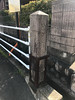
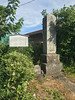
Once there seems that numerous tumuli lay in this area. Now a hospital (Suzuka Kaisei byōin 鈴鹿回生病院) was built and only one tumulus remains in the parking area. This tumulus is regarded as a rare example of the gourd (double round) shaped tumulus along with Kanayama Kofun . It may be 2 round tumuli on a same hill.
You may be viewing yesterday's version of this page. To see the most up to date information please register for a free account.
Do not use the above information on other web sites or publications without permission of the contributor.
Nearby Images from Flickr


The above images may not be of the site on this page, but were taken nearby. They are loaded from Flickr so please click on them for image credits.
Click here to see more info for this site
Nearby sites
Click here to view sites on an interactive map of the areaKey: Red: member's photo, Blue: 3rd party photo, Yellow: other image, Green: no photo - please go there and take one, Grey: site destroyed
Download sites to:
KML (Google Earth)
GPX (GPS waypoints)
CSV (Garmin/Navman)
CSV (Excel)
To unlock full downloads you need to sign up as a Contributory Member. Otherwise downloads are limited to 50 sites.
Turn off the page maps and other distractions
Nearby sites listing. In the following links * = Image available
11.3km SSW 206° Akeai Kofun* Long Barrow
22.1km WSW 243° Shin-Daibutsu-ji temple* Modern Stone Circle etc
28.1km S 191° Tempaku* Stone Circle
29.0km NW 325° Aidani Kumahara* Ancient Village or Settlement
35.0km NW 312° Ishidō-ji temple* Ancient Temple
36.4km WSW 237° Jonokoshi* Holy Well or Sacred Spring
39.6km NW 316° Matsuo Jinja shrine* Modern Stone Circle etc
39.9km NNE 15° Gyōki-ji temple* Modern Stone Circle etc
41.4km NW 310° Kōmyō-ji temple (in Shiga pref.)* Modern Stone Circle etc
41.9km SSW 205° Kitabatake Family Residence garden* Modern Stone Circle etc
43.7km NE 54° Nagoya Port replica Moai* Modern Stone Circle etc
44.3km NW 316° Kannonji-jō* Hillfort
45.3km SW 235° Tōdō Family Residence garden* Modern Stone Circle etc
45.4km NNW 339° Totonomiya Jinja shrine* Stone Circle
46.5km NE 42° Ryōun-ji temple* Modern Stone Circle etc
47.0km WNW 294° ShinZenkō-ji temple* Modern Stone Circle etc
48.8km WNW 291° Wada Kofungun* Passage Grave
49.8km WSW 245° Nabekurakei* Natural Stone / Erratic / Other Natural Feature
51.5km NNW 336° Ryōtan-ji temple (in Shiga pref.)* Modern Stone Circle etc
51.6km NNW 335° RakuRaku-en* Modern Stone Circle etc
51.8km WSW 257° Magai-butsu of Kasagi-dera temple* Carving
51.8km NE 46° Nagoya Castle* Modern Stone Circle etc
51.9km WNW 290° Kusatsu Honjin* Modern Stone Circle etc
53.5km E 92° Kezō-ji temple* Modern Stone Circle etc
53.9km NNW 340° Seigan-ji temple* Modern Stone Circle etc
View more nearby sites and additional images


 We would like to know more about this location. Please feel free to add a brief description and any relevant information in your own language.
 Wir möchten mehr über diese Stätte erfahren. Bitte zögern Sie nicht, eine kurze Beschreibung und relevante Informationen in Deutsch hinzuzufügen.
 Nous aimerions en savoir encore un peu sur les lieux. S'il vous plaît n'hesitez pas à ajouter une courte description et tous les renseignements pertinents dans votre propre langue.
 Quisieramos informarnos un poco más de las lugares. No dude en añadir una breve descripción y otros datos relevantes en su propio idioma.