

<< Our Photo Pages >> Indian Mound Park - Artificial Mound in United States in Great Lakes Midwest
Submitted by bat400 on Monday, 06 September 2010 Page Views: 10025
Date UncertainSite Name: Indian Mound Park Alternative Name: Shoaf Mound(s)Country: United States
NOTE: This site is 8.356 km away from the location you searched for.
Region: Great Lakes Midwest Type: Artificial Mound
Nearest Town: Columbus, OH
Latitude: 39.883000N Longitude: 82.9894W
Condition:
| 5 | Perfect |
| 4 | Almost Perfect |
| 3 | Reasonable but with some damage |
| 2 | Ruined but still recognisable as an ancient site |
| 1 | Pretty much destroyed, possibly visible as crop marks |
| 0 | No data. |
| -1 | Completely destroyed |
| 5 | Superb |
| 4 | Good |
| 3 | Ordinary |
| 2 | Not Good |
| 1 | Awful |
| 0 | No data. |
| 5 | Can be driven to, probably with disabled access |
| 4 | Short walk on a footpath |
| 3 | Requiring a bit more of a walk |
| 2 | A long walk |
| 1 | In the middle of nowhere, a nightmare to find |
| 0 | No data. |
| 5 | co-ordinates taken by GPS or official recorded co-ordinates |
| 4 | co-ordinates scaled from a detailed map |
| 3 | co-ordinates scaled from a bad map |
| 2 | co-ordinates of the nearest village |
| 1 | co-ordinates of the nearest town |
| 0 | no data |
Internal Links:
External Links:
I have visited· I would like to visit
eirrac5 would like to visit
bat400 visited on 1st Oct 2009 - their rating: Cond: 1 Amb: 2 Access: 5
")
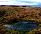
This was farmland under the plow before the public park was created. It contains a much reduced artificial mound, documented by the first European settlers to the area, but with little documentation indicating any study or designation to a particular prehistoric period.
Another low mound can be seen at the north edge of the park at the shared properly line with modern homes. Recently, doubts have been raised on whether these actually are artificially created mounds, but they were identified as such in the 19th century and are still listed as such in many catalogs, books, and websites.
The park is just off of Parsons Avenue in south Columbus.
[Some information from: Indian Mounds of the Middle Ohio Valley, Susan L Woodward and Jerry N McDonald. 2002, the McDonald and Woodward Publishing Company, Blacksburg VA.History of the City of Columbus, Alfred E. Lee. 1892.]
Note: Dirt hills or Indian mounds? "It's a little tough to pinpoint what's there, if they're going to develop the area, it's worth a look."
You may be viewing yesterday's version of this page. To see the most up to date information please register for a free account.
")
")
Do not use the above information on other web sites or publications without permission of the contributor.
Nearby Images from Flickr


The above images may not be of the site on this page, but were taken nearby. They are loaded from Flickr so please click on them for image credits.
Click here to see more info for this site
Nearby sites
Click here to view sites on an interactive map of the areaKey: Red: member's photo, Blue: 3rd party photo, Yellow: other image, Green: no photo - please go there and take one, Grey: site destroyed
Download sites to:
KML (Google Earth)
GPX (GPS waypoints)
CSV (Garmin/Navman)
CSV (Excel)
To unlock full downloads you need to sign up as a Contributory Member. Otherwise downloads are limited to 50 sites.
Turn off the page maps and other distractions
Nearby sites listing. In the following links * = Image available
13.5km N 1° Ohio Historical Center* Museum
14.2km NNW 327° Shrum Mound* Artificial Mound
23.7km N 350° Jeffers Mound* Artificial Mound
27.4km NNW 339° Wright-Holder Works* Misc. Earthwork
28.8km N 353° Highbanks Park Works* Hillfort
29.6km N 354° Highbanks Mound II* Artificial Mound
30.5km N 355° Highbanks Mound I* Artificial Mound
31.5km S 173° Circleville* Misc. Earthwork
34.4km S 173° Luthor List Mound* Artificial Mound
39.7km SSE 154° Tarlton Cross* Artificial Mound
43.4km ENE 69° Infirmary Mound Artificial Mound
46.5km ENE 63° Alligator Mound* Artificial Mound
50.0km ENE 68° Newark Earthworks - Octagon* Misc. Earthwork
50.7km ENE 70° Newark Earthworks - Great Circle* Misc. Earthwork
51.1km ENE 65° Ferris Owen* Artificial Mound
51.6km ENE 69° Newark Earthworks - Wright* Misc. Earthwork
52.2km E 80° Fairmount* Artificial Mound
52.6km ENE 67° Upham* Artificial Mound
53.2km SSE 154° Karshner Mound Artificial Mound
53.6km S 179° Cedar Banks Works* Ancient Village or Settlement
55.2km S 179° Hopeton Earthworks* Artificial Mound
55.3km ENE 78° Tippett Mound Artificial Mound
55.8km SSW 198° Frankfort Works Mound* Ancient Village or Settlement
56.4km S 181° Hopewell Culture National Historic Site* Misc. Earthwork
57.0km NE 44° Dixon Mound* Artificial Mound
View more nearby sites and additional images


 We would like to know more about this location. Please feel free to add a brief description and any relevant information in your own language.
 Wir möchten mehr über diese Stätte erfahren. Bitte zögern Sie nicht, eine kurze Beschreibung und relevante Informationen in Deutsch hinzuzufügen.
 Nous aimerions en savoir encore un peu sur les lieux. S'il vous plaît n'hesitez pas à ajouter une courte description et tous les renseignements pertinents dans votre propre langue.
 Quisieramos informarnos un poco más de las lugares. No dude en añadir una breve descripción y otros datos relevantes en su propio idioma.