<< Our Photo Pages >> Roskruge Beacon - Round Barrow(s) in England in Cornwall
Submitted by maengurta on Monday, 01 September 2008 Page Views: 6319
Neolithic and Bronze AgeSite Name: Roskruge BeaconCountry: England
NOTE: This site is 0.58 km away from the location you searched for.
County: Cornwall Type: Round Barrow(s)
Nearest Town: St Keverne Nearest Village: Porthallow
Map Ref: SW7796623106
Latitude: 50.066527N Longitude: 5.103932W
Condition:
| 5 | Perfect |
| 4 | Almost Perfect |
| 3 | Reasonable but with some damage |
| 2 | Ruined but still recognisable as an ancient site |
| 1 | Pretty much destroyed, possibly visible as crop marks |
| 0 | No data. |
| -1 | Completely destroyed |
| 5 | Superb |
| 4 | Good |
| 3 | Ordinary |
| 2 | Not Good |
| 1 | Awful |
| 0 | No data. |
| 5 | Can be driven to, probably with disabled access |
| 4 | Short walk on a footpath |
| 3 | Requiring a bit more of a walk |
| 2 | A long walk |
| 1 | In the middle of nowhere, a nightmare to find |
| 0 | No data. |
| 5 | co-ordinates taken by GPS or official recorded co-ordinates |
| 4 | co-ordinates scaled from a detailed map |
| 3 | co-ordinates scaled from a bad map |
| 2 | co-ordinates of the nearest village |
| 1 | co-ordinates of the nearest town |
| 0 | no data |
Internal Links:
External Links:
I have visited· I would like to visit
SolarMegalith would like to visit
lucasn visited on 4th May 2019 - their rating: Cond: 4 Amb: 4 Access: 5
")
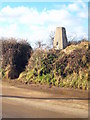
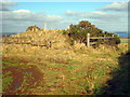
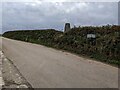
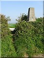
Round barrow in good condition about a mile north-west of St Keverne on the Lizard.
The barrow crowns the top of Roscruge Beacon, with good views over towards the Helford. The hill is most likely named after the barrow with 'crug' being Cornish for tomb or barrow.
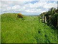
Access There is a stile into the field for access although no footpath marked.
You may be viewing yesterday's version of this page. To see the most up to date information please register for a free account.
")
")
")
Do not use the above information on other web sites or publications without permission of the contributor.
Nearby Images from Geograph Britain and Ireland:
©2010(licence)
©2010(licence)
©2024(licence)
©2015(licence)
©2019(licence)
The above images may not be of the site on this page, they are loaded from Geograph.
Please Submit an Image of this site or go out and take one for us!
Click here to see more info for this site
Nearby sites
Key: Red: member's photo, Blue: 3rd party photo, Yellow: other image, Green: no photo - please go there and take one, Grey: site destroyed
Download sites to:
KML (Google Earth)
GPX (GPS waypoints)
CSV (Garmin/Navman)
CSV (Excel)
To unlock full downloads you need to sign up as a Contributory Member. Otherwise downloads are limited to 50 sites.
Turn off the page maps and other distractions
Nearby sites listing. In the following links * = Image available
1.5km NW 308° Boden Fogou* Souterrain (Fogou, Earth House) (SW768241)
2.1km S 182° Tremenhere Menhir* Standing Stone (Menhir) (SW778210)
2.4km NW 315° Manaccan Well* Holy Well or Sacred Spring (SW763249)
2.5km N 3° St Anthony in Meneage Cross* Ancient Cross (SW782256)
2.6km N 5° St Anthony's Well (St Anthony-in-Meneag)* Holy Well or Sacred Spring (SW783257)
2.6km NNE 13° Little Dennis* Promontory Fort / Cliff Castle (SW7864425648)
3.0km ESE 121° Giant's Quoits* Rock Outcrop (SW80452145)
3.1km S 186° Crousa Common* Standing Stones (SW775200)
3.3km S 188° St Keverne Beacon Tumulus* Chambered Cairn (SW77361987)
3.6km S 187° Little Kistles Kerb Cairn* Cairn (SW77411959)
3.8km SSW 206° Three Brothers of Grugith* Burial Chamber or Dolmen (SW76161978)
4.0km S 186° Crousa Downs Settlement* Ancient Village or Settlement (SW77401916)
4.0km SSW 193° Tide Rock* Rock Outcrop (SW76921923)
4.2km SE 145° Lowland Point* Ancient Village or Settlement (SW80251952)
4.3km N 7° St Mawnan's Well* Holy Well or Sacred Spring (SW7868527385)
4.6km WSW 242° Traboe Barrow Cemetery* Barrow Cemetery (SW7378321099)
5.1km NNE 17° Rosemullion Head* Promontory Fort / Cliff Castle (SW79682788)
5.3km WNW 283° Caervallack Holy Well Holy Well or Sacred Spring (SW7279724512)
5.5km WNW 283° Caervallack Fort* Hillfort (SW7261624555)
5.7km WSW 251° Goonhilly tumuli* Round Barrow(s) (SW725215)
5.7km S 172° Chynhalls Point Fort* Promontory Fort / Cliff Castle (SW785174)
5.7km WSW 248° Dry Tree Menhir* Standing Stone (Menhir) (SW72562116)
6.1km WNW 284° Gear Round (Helston)* Hillfort (SW7209324805)
6.4km SW 232° Croft Pascoe Forrest Barrows* Barrow Cemetery (SW7273819434)
6.7km W 275° Halliggye* Souterrain (Fogou, Earth House) (SW71312394)
View more nearby sites and additional images


 We would like to know more about this location. Please feel free to add a brief description and any relevant information in your own language.
 Wir möchten mehr über diese Stätte erfahren. Bitte zögern Sie nicht, eine kurze Beschreibung und relevante Informationen in Deutsch hinzuzufügen.
 Nous aimerions en savoir encore un peu sur les lieux. S'il vous plaît n'hesitez pas à ajouter une courte description et tous les renseignements pertinents dans votre propre langue.
 Quisieramos informarnos un poco más de las lugares. No dude en añadir una breve descripción y otros datos relevantes en su propio idioma.