


<< Our Photo Pages >> St Naunter's Holy Well Remnant. - Holy Well or Sacred Spring in England in Cornwall
Submitted by hoya105 on Saturday, 20 July 2019 Page Views: 948
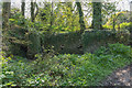
Springs and Holy WellsSite Name: St Naunter's Holy Well Remnant. Alternative Name: Trevillick Farm BarnCountry: England
NOTE: This site is 1.056 km away from the location you searched for.
County: Cornwall Type: Holy Well or Sacred Spring
Nearest Town: St Austell Nearest Village: Grampound
Map Ref: SW938492
Latitude: 50.306608N Longitude: 4.897143W
Condition:
| 5 | Perfect |
| 4 | Almost Perfect |
| 3 | Reasonable but with some damage |
| 2 | Ruined but still recognisable as an ancient site |
| 1 | Pretty much destroyed, possibly visible as crop marks |
| 0 | No data. |
| -1 | Completely destroyed |
| 5 | Superb |
| 4 | Good |
| 3 | Ordinary |
| 2 | Not Good |
| 1 | Awful |
| 0 | No data. |
| 5 | Can be driven to, probably with disabled access |
| 4 | Short walk on a footpath |
| 3 | Requiring a bit more of a walk |
| 2 | A long walk |
| 1 | In the middle of nowhere, a nightmare to find |
| 0 | No data. |
| 5 | co-ordinates taken by GPS or official recorded co-ordinates |
| 4 | co-ordinates scaled from a detailed map |
| 3 | co-ordinates scaled from a bad map |
| 2 | co-ordinates of the nearest village |
| 1 | co-ordinates of the nearest town |
| 0 | no data |
Internal Links:
External Links:
")
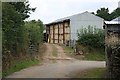
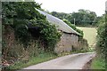
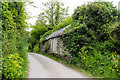
This is a sad remnant of a popular Holy Well and Chapel that stood nearby. It was a place of pilgrimage but when it fell into disrepair some stones were reused in the fabric of the barn. Stone from the well can be seen quite obviously from Pepo Lane that leads northwards out of Grampound - the barn is part of Trevillick Farm and is found on the right hand side just after the small turning to Nantellan.
You may be viewing yesterday's version of this page. To see the most up to date information please register for a free account.
Do not use the above information on other web sites or publications without permission of the contributor.
Nearby Images from Geograph Britain and Ireland:
©2006(licence)
©2020(licence)
©2006(licence)
©2020(licence)
©2020(licence)
The above images may not be of the site on this page, they are loaded from Geograph.
Please Submit an Image of this site or go out and take one for us!
Click here to see more info for this site
Nearby sites
Key: Red: member's photo, Blue: 3rd party photo, Yellow: other image, Green: no photo - please go there and take one, Grey: site destroyed
Download sites to:
KML (Google Earth)
GPX (GPS waypoints)
CSV (Garmin/Navman)
CSV (Excel)
To unlock full downloads you need to sign up as a Contributory Member. Otherwise downloads are limited to 50 sites.
Turn off the page maps and other distractions
Nearby sites listing. In the following links * = Image available
660m NW 318° Ladock Earthworks Promontory Fort / Cliff Castle (SW93384971)
1.8km N 4° Resugga Castle* Ancient Village or Settlement (SW940510)
2.2km WSW 243° Carvossa* Ancient Village or Settlement (SW918483)
2.7km SSW 208° Golden Camp* Hillfort (SW92454685)
3.6km W 271° Ventonglidder Holy Well or Sacred Spring (SW9015149402)
4.3km S 191° St Cuby's Well (Tregony)* Holy Well or Sacred Spring (SW928450)
4.5km NE 35° Langerth Round* Ancient Village or Settlement (SW96515277)
4.7km WNW 300° Fentonladock* Holy Well or Sacred Spring (SW8978851719)
5.7km NNE 19° St Stephens Beacon* Hillfort (SW959545)
5.9km WSW 242° Trelowthas Cross* Ancient Cross (SW885466)
6.3km ENE 62° St Mewan's Well* Holy Well or Sacred Spring (SW995519)
7.7km E 90° Towan* Holy Well or Sacred Spring (SX015489)
8.2km ENE 65° The Mengu Stone* Marker Stone (SX014524)
8.3km SSW 209° St Ruan's Well (Ruan Lanihorne)* Holy Well or Sacred Spring (SW894421)
8.4km ENE 59° Menacuddle* Holy Well or Sacred Spring (SX0118753260)
8.5km NNE 31° Cocksbarrow Timber Circle (SW985563)
8.9km E 85° Castle Gotha* Ancient Village or Settlement (SX027496)
8.9km SSE 152° Standing Stone to the East of Porthluney Bay* Standing Stone (Menhir) (SW97654114)
9.0km NNW 327° St Enoder Cross* Ancient Cross (SW892569)
9.2km N 6° St Dennis Hill Fort* Hillfort (SW951583)
9.2km N 6° St Dennis Churchyard Cross* Ancient Cross (SW95155835)
9.6km ENE 70° Gwallon Longstone* Standing Stone (Menhir) (SX02965212)
9.9km S 191° Veryan Well* Holy Well or Sacred Spring (SW9157839571)
10.0km SW 235° St Clement's Well* Holy Well or Sacred Spring (SW853438)
10.1km E 95° Black Head* Promontory Fort / Cliff Castle (SX039480)
View more nearby sites and additional images


 We would like to know more about this location. Please feel free to add a brief description and any relevant information in your own language.
 Wir möchten mehr über diese Stätte erfahren. Bitte zögern Sie nicht, eine kurze Beschreibung und relevante Informationen in Deutsch hinzuzufügen.
 Nous aimerions en savoir encore un peu sur les lieux. S'il vous plaît n'hesitez pas à ajouter une courte description et tous les renseignements pertinents dans votre propre langue.
 Quisieramos informarnos un poco más de las lugares. No dude en añadir una breve descripción y otros datos relevantes en su propio idioma.