


<< Our Photo Pages >> St Enoder Cross - Ancient Cross in England in Cornwall
Submitted by lucasn on Saturday, 07 July 2018 Page Views: 1024
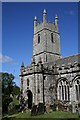
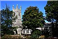
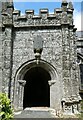
Early Medieval (Dark Age)Site Name: St Enoder Cross Alternative Name: St Enoder Church CrossCountry: England County: Cornwall Type: Ancient Cross
Nearest Town: Newquay Nearest Village: Summercourt
Map Ref: SW892569
Latitude: 50.374136N Longitude: 4.96596W
Condition:
| 5 | Perfect |
| 4 | Almost Perfect |
| 3 | Reasonable but with some damage |
| 2 | Ruined but still recognisable as an ancient site |
| 1 | Pretty much destroyed, possibly visible as crop marks |
| 0 | No data. |
| -1 | Completely destroyed |
| 5 | Superb |
| 4 | Good |
| 3 | Ordinary |
| 2 | Not Good |
| 1 | Awful |
| 0 | No data. |
| 5 | Can be driven to, probably with disabled access |
| 4 | Short walk on a footpath |
| 3 | Requiring a bit more of a walk |
| 2 | A long walk |
| 1 | In the middle of nowhere, a nightmare to find |
| 0 | No data. |
| 5 | co-ordinates taken by GPS or official recorded co-ordinates |
| 4 | co-ordinates scaled from a detailed map |
| 3 | co-ordinates scaled from a bad map |
| 2 | co-ordinates of the nearest village |
| 1 | co-ordinates of the nearest town |
| 0 | no data |
Internal Links:
External Links:
I have visited· I would like to visit
lucasn visited on 7th Jul 2018 - their rating: Cond: 4 Amb: 3 Access: 5
")
An ancient cross next to the gate in the grounds of St Enoder Church
You may be viewing yesterday's version of this page. To see the most up to date information please register for a free account.
Do not use the above information on other web sites or publications without permission of the contributor.
Nearby Images from Geograph Britain and Ireland:
©2006(licence)
©2006(licence)
©2010(licence)

©2023(licence)
©2023(licence)
The above images may not be of the site on this page, they are loaded from Geograph.
Please Submit an Image of this site or go out and take one for us!
Click here to see more info for this site
Nearby sites
Key: Red: member's photo, Blue: 3rd party photo, Yellow: other image, Green: no photo - please go there and take one, Grey: site destroyed
Download sites to:
KML (Google Earth)
GPX (GPS waypoints)
CSV (Garmin/Navman)
CSV (Excel)
To unlock full downloads you need to sign up as a Contributory Member. Otherwise downloads are limited to 50 sites.
Turn off the page maps and other distractions
Nearby sites listing. In the following links * = Image available
3.3km NE 45° Indian Queens inscribed stone* Early Christian Sculptured Stone (SW91625912)
3.3km WNW 287° Dairyland Farm World* Modern Stone Circle etc (SW861580)
4.1km NW 326° Our Lady of Nance* Holy Well or Sacred Spring (SW870604)
4.9km NE 39° St Columba Holy Well* Holy Well or Sacred Spring (SW925606)
5.2km S 171° Fentonladock* Holy Well or Sacred Spring (SW8978851719)
5.5km SW 235° Warren's Barrow* Barrow Cemetery (SW846539)
5.9km NNE 30° Devil's Quoit (St Columb Major)* Burial Chamber or Dolmen (SW9234161952)
6.0km ENE 74° St Dennis Hill Fort* Hillfort (SW951583)
6.1km ENE 74° St Dennis Churchyard Cross* Ancient Cross (SW95155835)
6.3km NW 325° St. Pedyr's Well* Holy Well or Sacred Spring (SW8579462245)
6.3km NE 51° Deep Tye Farm Henge (SW943607)
6.7km NW 316° Rialton Manor* Holy Well or Sacred Spring (SW847619)
7.1km ESE 107° St Stephens Beacon* Hillfort (SW959545)
7.6km S 171° Ventonglidder Holy Well or Sacred Spring (SW9015149402)
7.6km SE 139° Resugga Castle* Ancient Village or Settlement (SW940510)
7.6km NE 42° Castle an Dinas (St Columb)* Hillfort (SW94556236)
8.3km SSE 148° Ladock Earthworks Promontory Fort / Cliff Castle (SW93384971)
8.4km ESE 117° Langerth Round* Ancient Village or Settlement (SW96515277)
8.6km NNW 344° St James's Well, Ball* Holy Well or Sacred Spring (SW8709865269)
8.9km WNW 291° Treringey Round* Ancient Village or Settlement (SW810604)
9.0km SSE 147° St Naunter's Holy Well Remnant.* Holy Well or Sacred Spring (SW938492)
9.0km NW 317° Zachry's Barrows* Barrow Cemetery (SW83356371)
9.0km SSE 161° Carvossa* Ancient Village or Settlement (SW918483)
9.0km NW 304° Barrowfields* Barrow Cemetery (SW819622)
9.1km NW 311° Trevelgue* Barrow Cemetery (SW825631)
View more nearby sites and additional images


 We would like to know more about this location. Please feel free to add a brief description and any relevant information in your own language.
 Wir möchten mehr über diese Stätte erfahren. Bitte zögern Sie nicht, eine kurze Beschreibung und relevante Informationen in Deutsch hinzuzufügen.
 Nous aimerions en savoir encore un peu sur les lieux. S'il vous plaît n'hesitez pas à ajouter une courte description et tous les renseignements pertinents dans votre propre langue.
 Quisieramos informarnos un poco más de las lugares. No dude en añadir una breve descripción y otros datos relevantes en su propio idioma.