


<< Our Photo Pages >> Thurba Fort - Hillfort in Wales in West Glamorgan
Submitted by vicky on Wednesday, 25 February 2004 Page Views: 8770
Iron Age and Later PrehistorySite Name: Thurba FortCountry: Wales
NOTE: This site is 0.749 km away from the location you searched for.
County: West Glamorgan Type: Hillfort
Nearest Town: Bishopston Nearest Village: Rhossili
Map Ref: SS42148704 Landranger Map Number: 159
Latitude: 51.560088N Longitude: 4.278681W
Condition:
| 5 | Perfect |
| 4 | Almost Perfect |
| 3 | Reasonable but with some damage |
| 2 | Ruined but still recognisable as an ancient site |
| 1 | Pretty much destroyed, possibly visible as crop marks |
| 0 | No data. |
| -1 | Completely destroyed |
| 5 | Superb |
| 4 | Good |
| 3 | Ordinary |
| 2 | Not Good |
| 1 | Awful |
| 0 | No data. |
| 5 | Can be driven to, probably with disabled access |
| 4 | Short walk on a footpath |
| 3 | Requiring a bit more of a walk |
| 2 | A long walk |
| 1 | In the middle of nowhere, a nightmare to find |
| 0 | No data. |
| 5 | co-ordinates taken by GPS or official recorded co-ordinates |
| 4 | co-ordinates scaled from a detailed map |
| 3 | co-ordinates scaled from a bad map |
| 2 | co-ordinates of the nearest village |
| 1 | co-ordinates of the nearest town |
| 0 | no data |
Be the first person to rate this site - see the 'Contribute!' box in the right hand menu.
Internal Links:
External Links:
I have visited· I would like to visit
PAB visited on 3rd Jul 2011 - their rating: Cond: 2 Amb: 4 Access: 3
")
Have you visited this site? Please add a comment below.
You may be viewing yesterday's version of this page. To see the most up to date information please register for a free account.
")
")
")
Do not use the above information on other web sites or publications without permission of the contributor.
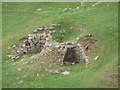
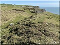
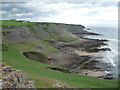
Nearby Images from Geograph Britain and Ireland:

©2024(licence)

©2012(licence)
©2012(licence)
©2021(licence)
©2012(licence)
The above images may not be of the site on this page, they are loaded from Geograph.
Please Submit an Image of this site or go out and take one for us!
Click here to see more info for this site
Nearby sites
Key: Red: member's photo, Blue: 3rd party photo, Yellow: other image, Green: no photo - please go there and take one, Grey: site destroyed
Download sites to:
KML (Google Earth)
GPX (GPS waypoints)
CSV (Garmin/Navman)
CSV (Excel)
To unlock full downloads you need to sign up as a Contributory Member. Otherwise downloads are limited to 50 sites.
Turn off the page maps and other distractions
Nearby sites listing. In the following links * = Image available
305m NNE 30° Mewslade Caves* Cave or Rock Shelter (SS423873)
580m ESE 115° Red Fescue Hole Cave or Rock Shelter (SS42668678)
1.1km NNW 337° Rhossili millenium stone* Modern Stone Circle etc (SS41738811)
1.2km ESE 121° The Knave* Hillfort (SS43188637)
1.3km ESE 123° Cwtch Cave Cave or Rock Shelter (SS432863)
1.3km NW 323° Rhossili Visitor Centre* Museum (SS414881)
1.4km ESE 121° Deborah's Hole Cave or Rock Shelter (SS433863)
1.5km NW 306° Old Castle Camp* Promontory Fort / Cliff Castle (SS40938799)
1.6km SE 128° Horse Cliff Hillfort (SS434860)
1.7km N 355° Rhossili Down Cairn 4* Cairn (SS42048877)
1.8km N 354° The Beacon (West Glamorgan)* Cairn (SS42008886)
1.9km N 0° Rhossili Down South 12* Ring Cairn (SS422889)
1.9km N 356° Rhossili Down Cairn 3* Cairn (SS42068894)
1.9km ESE 121° Yellow Top, Paviland Camp* Promontory Fort / Cliff Castle (SS43758600)
1.9km SE 125° Hound's Hole Cave Cave or Rock Shelter (SS43698589)
1.9km SE 125° Goat's Cave, Paviland* Cave or Rock Shelter (SS43718588)
2.0km ESE 119° Foxhole Slade Cave* Cave or Rock Shelter (SS43848601)
2.0km N 356° Rhossili Down Cairn 2* Ring Cairn (SS42078903)
2.1km N 355° Rhossili Down Cairn 1 * Cairn (SS42028918)
2.2km N 359° Rhossili Down ring cairn* Ring Cairn (SS42178929)
2.3km N 1° Rhossili Down Cairn 5* Ring Cairn (SS42278938)
2.7km N 358° Sweyne's Howse ring cairn* Ring Cairn (SS42148977)
2.8km N 2° Rhosili Down Settlement Ancient Village or Settlement (SS42328980)
2.8km N 357° Sweyne's Howes South* Chambered Tomb (SS42108982)
2.8km W 279° Worms Head, Promontary Fort* Promontory Fort / Cliff Castle (SS39378757)
View more nearby sites and additional images


 We would like to know more about this location. Please feel free to add a brief description and any relevant information in your own language.
 Wir möchten mehr über diese Stätte erfahren. Bitte zögern Sie nicht, eine kurze Beschreibung und relevante Informationen in Deutsch hinzuzufügen.
 Nous aimerions en savoir encore un peu sur les lieux. S'il vous plaît n'hesitez pas à ajouter une courte description et tous les renseignements pertinents dans votre propre langue.
 Quisieramos informarnos un poco más de las lugares. No dude en añadir una breve descripción y otros datos relevantes en su propio idioma.