


<< Our Photo Pages >> The Knave - Hillfort in Wales in West Glamorgan
Submitted by vicky on Wednesday, 25 February 2004 Page Views: 6985
Iron Age and Later PrehistorySite Name: The Knave Alternative Name: Deborah's Hole CampCountry: Wales County: West Glamorgan Type: Hillfort
Nearest Town: Swansea Nearest Village: Rhossili
Map Ref: SS43188637 Landranger Map Number: 159
Latitude: 51.554359N Longitude: 4.263392W
Condition:
| 5 | Perfect |
| 4 | Almost Perfect |
| 3 | Reasonable but with some damage |
| 2 | Ruined but still recognisable as an ancient site |
| 1 | Pretty much destroyed, possibly visible as crop marks |
| 0 | No data. |
| -1 | Completely destroyed |
| 5 | Superb |
| 4 | Good |
| 3 | Ordinary |
| 2 | Not Good |
| 1 | Awful |
| 0 | No data. |
| 5 | Can be driven to, probably with disabled access |
| 4 | Short walk on a footpath |
| 3 | Requiring a bit more of a walk |
| 2 | A long walk |
| 1 | In the middle of nowhere, a nightmare to find |
| 0 | No data. |
| 5 | co-ordinates taken by GPS or official recorded co-ordinates |
| 4 | co-ordinates scaled from a detailed map |
| 3 | co-ordinates scaled from a bad map |
| 2 | co-ordinates of the nearest village |
| 1 | co-ordinates of the nearest town |
| 0 | no data |
Internal Links:
External Links:
I have visited· I would like to visit
PAB has visited here
")
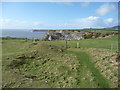
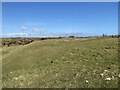
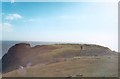
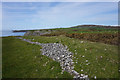
From PAB: This Iron Age hillfort is perched on the edge of cliffs 60 metres high, with magnificent views along the Gower coastline.
Much of the central area has been eroded, and this can be very well seen in the series of aerial photos on Coflein site no.301326.
The RCAHMW describes the site and finds as follows:
"The Knave promontory fort is a bivallate defended enclosure, c.52m by 44m internally, with the outer defences set 14-20m from the inner circuit, resting on 60m cliffs to the S. Excavations (1938) showed the inner rampart to have been internally revetted & fronted by a ditch, the outer line being boulder-kerbed internally & also ditched; an internal structure, 3.7m in diameter, was examined; the ceramic assemblage was thought to be of c.50BC-50AD."
You may be viewing yesterday's version of this page. To see the most up to date information please register for a free account.
")
")
Do not use the above information on other web sites or publications without permission of the contributor.
Nearby Images from Geograph Britain and Ireland:
©2011(licence)
©2021(licence)
©2012(licence)
©2006(licence)
©2016(licence)
The above images may not be of the site on this page, they are loaded from Geograph.
Please Submit an Image of this site or go out and take one for us!
Click here to see more info for this site
Nearby sites
Key: Red: member's photo, Blue: 3rd party photo, Yellow: other image, Green: no photo - please go there and take one, Grey: site destroyed
Download sites to:
KML (Google Earth)
GPX (GPS waypoints)
CSV (Garmin/Navman)
CSV (Excel)
To unlock full downloads you need to sign up as a Contributory Member. Otherwise downloads are limited to 50 sites.
Turn off the page maps and other distractions
Nearby sites listing. In the following links * = Image available
73m SSE 162° Cwtch Cave Cave or Rock Shelter (SS432863)
139m ESE 119° Deborah's Hole Cave or Rock Shelter (SS433863)
430m SSE 148° Horse Cliff Hillfort (SS434860)
661m NW 307° Red Fescue Hole Cave or Rock Shelter (SS42668678)
678m ESE 121° Yellow Top, Paviland Camp* Promontory Fort / Cliff Castle (SS43758600)
699m SE 132° Hound's Hole Cave Cave or Rock Shelter (SS43698589)
720m SE 131° Goat's Cave, Paviland* Cave or Rock Shelter (SS43718588)
750m ESE 117° Foxhole Slade Cave* Cave or Rock Shelter (SS43848601)
1.2km WNW 301° Thurba Fort* Hillfort (SS42148704)
1.3km NW 315° Mewslade Caves* Cave or Rock Shelter (SS423873)
2.3km NW 318° Rhossili millenium stone* Modern Stone Circle etc (SS41738811)
2.4km ESE 120° Long Hole* Cave or Rock Shelter (SS452851)
2.5km NW 312° Rhossili Visitor Centre* Museum (SS414881)
2.7km NNW 333° Rhossili Down Cairn 4* Cairn (SS42048877)
2.7km NNW 337° Rhossili Down South 12* Ring Cairn (SS422889)
2.8km NNW 333° The Beacon (West Glamorgan)* Cairn (SS42008886)
2.8km NW 304° Old Castle Camp* Promontory Fort / Cliff Castle (SS40938799)
2.8km NNW 335° Rhossili Down Cairn 3* Cairn (SS42068894)
2.9km NNW 336° Rhossili Down Cairn 2* Ring Cairn (SS42078903)
3.0km NNW 336° Rhossili Down Cairn 1 * Cairn (SS42028918)
3.1km NNW 339° Rhossili Down ring cairn* Ring Cairn (SS42178929)
3.1km NNW 341° Rhossili Down Cairn 5* Ring Cairn (SS42278938)
3.5km N 350° Rhossili Down Standing Stone* Standing Stone (Menhir) (SS4267189839)
3.5km NNW 344° Rhosili Down Settlement Ancient Village or Settlement (SS42328980)
3.6km NNW 341° Sweyne's Howse ring cairn* Ring Cairn (SS42148977)
View more nearby sites and additional images


 We would like to know more about this location. Please feel free to add a brief description and any relevant information in your own language.
 Wir möchten mehr über diese Stätte erfahren. Bitte zögern Sie nicht, eine kurze Beschreibung und relevante Informationen in Deutsch hinzuzufügen.
 Nous aimerions en savoir encore un peu sur les lieux. S'il vous plaît n'hesitez pas à ajouter une courte description et tous les renseignements pertinents dans votre propre langue.
 Quisieramos informarnos un poco más de las lugares. No dude en añadir una breve descripción y otros datos relevantes en su propio idioma.