<< Text Pages >> Broadwoodwidger Cross - Ancient Cross in England in Devon
Submitted by lucasn on Wednesday, 24 October 2018 Page Views: 814
Early Medieval (Dark Age)Site Name: Broadwoodwidger Cross Alternative Name: Broadwoodwidger Church CrossCountry: England
NOTE: This site is 1.15 km away from the location you searched for.
County: Devon Type: Ancient Cross
Nearest Town: Launceston Nearest Village: Broadwoodwidger
Map Ref: SX4112589159
Latitude: 50.680344N Longitude: 4.250152W
Condition:
| 5 | Perfect |
| 4 | Almost Perfect |
| 3 | Reasonable but with some damage |
| 2 | Ruined but still recognisable as an ancient site |
| 1 | Pretty much destroyed, possibly visible as crop marks |
| 0 | No data. |
| -1 | Completely destroyed |
| 5 | Superb |
| 4 | Good |
| 3 | Ordinary |
| 2 | Not Good |
| 1 | Awful |
| 0 | No data. |
| 5 | Can be driven to, probably with disabled access |
| 4 | Short walk on a footpath |
| 3 | Requiring a bit more of a walk |
| 2 | A long walk |
| 1 | In the middle of nowhere, a nightmare to find |
| 0 | No data. |
| 5 | co-ordinates taken by GPS or official recorded co-ordinates |
| 4 | co-ordinates scaled from a detailed map |
| 3 | co-ordinates scaled from a bad map |
| 2 | co-ordinates of the nearest village |
| 1 | co-ordinates of the nearest town |
| 0 | no data |
Internal Links:
External Links:
I have visited· I would like to visit
lucasn visited on 24th Oct 2018 - their rating: Cond: 4 Amb: 4 Access: 5
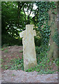
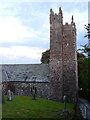
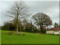
Ancient cross in front of the porch of St Nicholas' Church at Broadwoodwidger. The cross is a crucifix cross, probably Early Christian, which overlooks the valley towards Dartmoor. It is approximately 5.7 feet high.
For more information see Pastscape Monument NO. 438107 and Historic England List ID 1164985.
You may be viewing yesterday's version of this page. To see the most up to date information please register for a free account.
Do not use the above information on other web sites or publications without permission of the contributor.
Nearby Images from Geograph Britain and Ireland:
©2019(licence)
©2006(licence)
©2014(licence)
©2016(licence)
©2008(licence)
The above images may not be of the site on this page, they are loaded from Geograph.
Please Submit an Image of this site or go out and take one for us!
Click here to see more info for this site
Nearby sites
Key: Red: member's photo, Blue: 3rd party photo, Yellow: other image, Green: no photo - please go there and take one, Grey: site destroyed
Download sites to:
KML (Google Earth)
GPX (GPS waypoints)
CSV (Garmin/Navman)
CSV (Excel)
To unlock full downloads you need to sign up as a Contributory Member. Otherwise downloads are limited to 50 sites.
Turn off the page maps and other distractions
Nearby sites listing. In the following links * = Image available
4.9km SSW 205° Lifton Holy Well Holy Well or Sacred Spring (SX389848)
5.6km ESE 122° Lewtrenchard Holy Well* Holy Well or Sacred Spring (SX458861)
8.5km E 99° Burley Wood Hillfort Hillfort (SX49548754)
9.3km WSW 240° Maiden's Well (Launceston) Holy Well or Sacred Spring (SX32858477)
9.7km WSW 247° St Stephen's Well* Holy Well or Sacred Spring (SX320857)
10.0km NNE 34° Three Barrows, Patchacott* Barrow Cemetery (SX4693097301)
10.0km E 88° Bridestowe Holy Well Holy Well or Sacred Spring (SX512892)
10.1km SSW 207° Longstone Farm* Stone Row / Alignment (SX36218033)
10.4km N 7° Halwill Village Cross* Ancient Cross (SX4275199393)
10.4km N 7° Halwill Churchyard Cross* Ancient Cross (SX4272799412)
10.4km SE 136° North Brentor Well* Holy Well or Sacred Spring (SX4813881440)
10.6km SE 144° Brent Tor* Hillfort (SX4709780392)
10.8km ESE 112° Lydford Anglo Saxon Defences* Misc. Earthwork (SX51088487)
11.3km SSW 211° St Brigid's Well Holy Well or Sacred Spring (SX350796)
11.6km NNE 15° Halwill Great Barrows* Barrow Cemetery (SS4449200306)
12.1km SE 132° Gibbett Hill Ring Cairn (SX49958084)
12.3km E 83° Sourton Green Saxon Cross* Ancient Cross (SX534903)
12.3km SW 214° St Michael's Well (Lezant)* Holy Well or Sacred Spring
12.6km SSW 202° Rezare Holy Well* Holy Well or Sacred Spring (SX3607977615)
12.7km ESE 118° Ring of Bells* Ring Cairn (SX5214082873)
12.8km NW 307° St Denis Well, Holy Well, Sacred Spring* Holy Well or Sacred Spring (SX3109797178)
12.8km E 96° Great Nodden* Cist (SX5387487416)
13.0km W 272° St Paternus's Well* Holy Well or Sacred Spring (SX2813889895)
13.0km ESE 113° White Hill South* Ring Cairn (SX5294283680)
13.2km E 96° Little Links Tor* Stone Row / Alignment (SX5428587463)
View more nearby sites and additional images


 We would like to know more about this location. Please feel free to add a brief description and any relevant information in your own language.
 Wir möchten mehr über diese Stätte erfahren. Bitte zögern Sie nicht, eine kurze Beschreibung und relevante Informationen in Deutsch hinzuzufügen.
 Nous aimerions en savoir encore un peu sur les lieux. S'il vous plaît n'hesitez pas à ajouter une courte description et tous les renseignements pertinents dans votre propre langue.
 Quisieramos informarnos un poco más de las lugares. No dude en añadir una breve descripción y otros datos relevantes en su propio idioma.