<< Our Photo Pages >> Clach-na-Crudainn - Standing Stone (Menhir) in Scotland in Highlands
Submitted by howar on Wednesday, 13 February 2008 Page Views: 8322
Neolithic and Bronze AgeSite Name: Clach-na-Crudainn Alternative Name: Clachnacrudain, Clach na crudainn, Stone of the TuCountry: Scotland County: Highlands Type: Standing Stone (Menhir)
Nearest Town: Inverness
Map Ref: NH66684521
Latitude: 57.477476N Longitude: 4.225017W
Condition:
| 5 | Perfect |
| 4 | Almost Perfect |
| 3 | Reasonable but with some damage |
| 2 | Ruined but still recognisable as an ancient site |
| 1 | Pretty much destroyed, possibly visible as crop marks |
| 0 | No data. |
| -1 | Completely destroyed |
| 5 | Superb |
| 4 | Good |
| 3 | Ordinary |
| 2 | Not Good |
| 1 | Awful |
| 0 | No data. |
| 5 | Can be driven to, probably with disabled access |
| 4 | Short walk on a footpath |
| 3 | Requiring a bit more of a walk |
| 2 | A long walk |
| 1 | In the middle of nowhere, a nightmare to find |
| 0 | No data. |
| 5 | co-ordinates taken by GPS or official recorded co-ordinates |
| 4 | co-ordinates scaled from a detailed map |
| 3 | co-ordinates scaled from a bad map |
| 2 | co-ordinates of the nearest village |
| 1 | co-ordinates of the nearest town |
| 0 | no data |
Internal Links:
External Links:
I have visited· I would like to visit
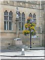
absynthia01 visited on 1st Jan 0007 - their rating: Cond: 3 Amb: 4 Access: 5 This stone is now part of the Merkat Cross which stands outside the townhowse on the corner of Bridge Street and Castle Street, Inverness. Acecss for disabled folk is superb.
livingstone visited - their rating: Cond: 4 Amb: 2 Access: 4 I pass this site regularly. If one dosn't mind fighting the crowds of shoppers, workers and tourists it makes interesting viewing in the middle of a busy town center. Incidently the stone is just a few yards from the excellent inverness museum
Average ratings for this site from all visit loggers: Condition: 3.5 Ambience: 3 Access: 4.5
")
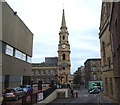
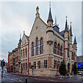
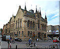
NMRS record no. NH64NE 11 is a rough parallelogram of bluish sandstone measuring 1m by 80cm, presently in front of Inverness Town Hall partially under the left-hand pillar by the High Street entrance. The English translation refers to its use as a resting place by wifeys bringing up water from the river {pehaps a later folk etymology ?] One author believes it to have been a standing stone but it is more usually credited as a former rocking stone traditionally brought here from a location west of Inverness where it had been a coronation stone for the Lords of the Isles. According to a seer, who used it as a seat, as long as it stayed here Inverness was safe, and it survived the sacking of the town by Donald of the Isles. At one time it was the base for the Old Market Cross. After Culloden a Highlander hanged from an apple-tree nearby. Latterly it was built into Forbes Fountain in front of what was then called the Exchange.
You may be viewing yesterday's version of this page. To see the most up to date information please register for a free account.
")
")
Do not use the above information on other web sites or publications without permission of the contributor.
coldrum has found this location on Google Street View:
Nearby Images from Geograph Britain and Ireland:
©2013(licence)
©2017(licence)
©2013(licence)
©2013(licence)
©2013(licence)
The above images may not be of the site on this page, they are loaded from Geograph.
Please Submit an Image of this site or go out and take one for us!
Click here to see more info for this site
Nearby sites
Key: Red: member's photo, Blue: 3rd party photo, Yellow: other image, Green: no photo - please go there and take one, Grey: site destroyed
Download sites to:
KML (Google Earth)
GPX (GPS waypoints)
CSV (Garmin/Navman)
CSV (Excel)
To unlock full downloads you need to sign up as a Contributory Member. Otherwise downloads are limited to 50 sites.
Turn off the page maps and other distractions
Nearby sites listing. In the following links * = Image available
20m S 178° Inverness Museum* Museum (NH66684519)
604m ESE 119° Broad Stone Early Christian Sculptured Stone (NH672449)
630m SW 228° Knocknagael* Class I Pictish Symbol Stone (NH662448)
2.1km E 92° Raigmore* Clava Cairn (NH6878445083)
2.4km E 89° Beechwood Farm Site Ancient Mine, Quarry or other Industry (NH6908045190)
2.4km ESE 104° Essich House Class I Pictish Symbol Stone (NH69004456)
2.7km W 268° Craig Phadraig* Vitrified Fort (NH640452)
3.7km SSE 149° Druidtemple* Stone Circle (NH685420)
3.9km WSW 252° Leachkin* Chambered Cairn (NH62964416)
4.3km ENE 65° Milton Stone Row Stone Row / Alignment (NH70704690)
4.9km WSW 245° Ladystone Farm* Stone Row / Alignment (NH62204330)
5.3km SSW 204° Torbreck* Stone Circle (NH64384039)
5.5km ENE 62° Allanfearn* Chambered Cairn (NH716476)
5.6km E 87° St Mary's Well (Culloden)* Holy Well or Sacred Spring (NH723453)
6.3km ENE 65° Cullearnie* Stone Circle (NH72504768)
7.1km ESE 110° Forrest Cottage* Chambered Cairn (NH733426)
7.1km SSW 193° Essich Moor* Chambered Cairn (NH649383)
7.3km ESE 122° Daviot Ring Cairn* Stone Circle (NH727411)
7.6km E 96° Culchunaig* Stone Circle (NH74194416)
7.6km ENE 62° Newton Of Petty Ring Cairn (NH73484858)
7.6km E 90° The Well of The Dead* Holy Well or Sacred Spring (NH7431844971)
7.6km E 94° Leanach Stone Circle (NH743444)
7.7km E 94° Leanach NE Chambered Cairn (NH74344444)
7.7km SW 214° Kinchyle Of Dores* Stone Circle (NH62153898)
7.9km S 170° Tomfat Plantation* Chambered Cairn (NH678374)
View more nearby sites and additional images


 We would like to know more about this location. Please feel free to add a brief description and any relevant information in your own language.
 Wir möchten mehr über diese Stätte erfahren. Bitte zögern Sie nicht, eine kurze Beschreibung und relevante Informationen in Deutsch hinzuzufügen.
 Nous aimerions en savoir encore un peu sur les lieux. S'il vous plaît n'hesitez pas à ajouter une courte description et tous les renseignements pertinents dans votre propre langue.
 Quisieramos informarnos un poco más de las lugares. No dude en añadir una breve descripción y otros datos relevantes en su propio idioma.