<< Our Photo Pages >> Queen's Well - Holy Well or Sacred Spring in Scotland in Angus
Submitted by KiwiBetsy on Wednesday, 24 January 2007 Page Views: 11915
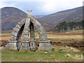
Springs and Holy WellsSite Name: Queen's Well Alternative Name: Well of the White Stone, Tobar na Clachan GealaichCountry: Scotland
NOTE: This site is 6.959 km away from the location you searched for.
County: Angus Type: Holy Well or Sacred Spring
Nearest Town: Edzell Nearest Village: Kirkton
Map Ref: NO419829
Latitude: 56.933722N Longitude: 2.95633W
Condition:
| 5 | Perfect |
| 4 | Almost Perfect |
| 3 | Reasonable but with some damage |
| 2 | Ruined but still recognisable as an ancient site |
| 1 | Pretty much destroyed, possibly visible as crop marks |
| 0 | No data. |
| -1 | Completely destroyed |
| 5 | Superb |
| 4 | Good |
| 3 | Ordinary |
| 2 | Not Good |
| 1 | Awful |
| 0 | No data. |
| 5 | Can be driven to, probably with disabled access |
| 4 | Short walk on a footpath |
| 3 | Requiring a bit more of a walk |
| 2 | A long walk |
| 1 | In the middle of nowhere, a nightmare to find |
| 0 | No data. |
| 5 | co-ordinates taken by GPS or official recorded co-ordinates |
| 4 | co-ordinates scaled from a detailed map |
| 3 | co-ordinates scaled from a bad map |
| 2 | co-ordinates of the nearest village |
| 1 | co-ordinates of the nearest town |
| 0 | no data |
Internal Links:
External Links:
")
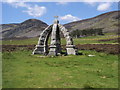
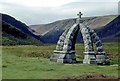
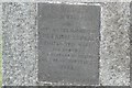
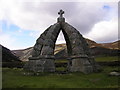
The Queen's Well is to be found in Glen Mark, which lies at the head of Glen Esk and to the north of Loch Lee. After staying at the nearby Invermark Lodge in September 1861, Queen Victoria and Prince Albert stopped at the spring, then known as White Well, to drink of it's refreshing waters before travelling further on up Glen Mark and on to their home at Balmoral Castle.
You may be viewing yesterday's version of this page. To see the most up to date information please register for a free account.
")
Do not use the above information on other web sites or publications without permission of the contributor.
Nearby Images from Geograph Britain and Ireland:
©2010(licence)
©2016(licence)
©2009(licence)
©2009(licence)
©2013(licence)
The above images may not be of the site on this page, they are loaded from Geograph.
Please Submit an Image of this site or go out and take one for us!
Click here to see more info for this site
Nearby sites
Key: Red: member's photo, Blue: 3rd party photo, Yellow: other image, Green: no photo - please go there and take one, Grey: site destroyed
Download sites to:
KML (Google Earth)
GPX (GPS waypoints)
CSV (Garmin/Navman)
CSV (Excel)
To unlock full downloads you need to sign up as a Contributory Member. Otherwise downloads are limited to 50 sites.
Turn off the page maps and other distractions
Nearby sites listing. In the following links * = Image available
6.3km E 91° Baillies White Cairn* Cairn (NO48248273)
13.3km NE 54° Ballochan Hut Circles Ancient Village or Settlement (NO528905)
13.5km NNW 332° Scurriestone* Standing Stone (Menhir) (NO357949)
14.7km N 349° Braehead Farm* Souterrain (Fogou, Earth House) (NO393974)
14.9km NNW 348° Tullich* Class I Pictish Symbol Stone (NO390975)
15.3km ESE 107° Colmeallie* Stone Circle (NO565781)
15.7km NNW 337° Abergairn Castle Ruins* Stone Fort or Dun (NO35869741)
16.1km N 8° Kinord earth house* Souterrain (Fogou, Earth House) (NO444988)
16.5km SSW 196° Whitehillock* Rock Art (NO37016716)
16.7km SSW 196° Whitehillocks Farm Stone Circle* Stone Circle (NO370669)
16.8km N 7° Loch Kinord Crannog* Crannog (NO443995)
17.0km N 6° Loch Kinord Cross Slab* Class III Pictish Cross Slab (NO44009978)
17.0km NNE 22° Ferrar Ancient Village or Settlement (NO485986)
17.4km N 6° Old Kinord Ancient Village or Settlement (NJ441002)
17.5km N 7° Hut Circles at Old Kinord* Ancient Village or Settlement (NJ444002)
17.7km NNE 14° Knockenzie Ancient Village or Settlement (NJ465000)
17.7km N 10° Monandavan Ring Cairn (NJ453003)
17.8km NW 317° Ballater-St.Manire* Standing Stone (Menhir) (NO300962)
18.2km SE 137° Newbigging Ring Cairn (NO541693)
18.8km NE 36° Waterside Hut Circles Ancient Village or Settlement (NO533979)
18.9km NNE 17° Balnacraig Cairn Aberdeenshire Chambered Cairn (NJ47830082)
19.1km NNE 21° Blue Cairn (Cairn)* Cairn (NJ49070059)
19.2km NNE 32° Image Wood* Stone Circle (NO524990)
19.8km NE 43° Birse* Class I Pictish Symbol Stone (NO555973)
20.0km ESE 122° Dalbog Stone Circle (NO587719)
View more nearby sites and additional images

")
 We would like to know more about this location. Please feel free to add a brief description and any relevant information in your own language.
 Wir möchten mehr über diese Stätte erfahren. Bitte zögern Sie nicht, eine kurze Beschreibung und relevante Informationen in Deutsch hinzuzufügen.
 Nous aimerions en savoir encore un peu sur les lieux. S'il vous plaît n'hesitez pas à ajouter une courte description et tous les renseignements pertinents dans votre propre langue.
 Quisieramos informarnos un poco más de las lugares. No dude en añadir una breve descripción y otros datos relevantes en su propio idioma.