<< Our Photo Pages >> Loch Kinord Crannog - Crannog in Scotland in Aberdeenshire
Submitted by cosmic on Sunday, 27 March 2005 Page Views: 9380
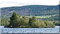
Iron Age and Later PrehistorySite Name: Loch Kinord CrannogCountry: Scotland County: Aberdeenshire Type: Crannog
Nearest Town: Aboyne Nearest Village: Dinet
Map Ref: NO443995
Latitude: 57.083119N Longitude: 2.920575W
Condition:
| 5 | Perfect |
| 4 | Almost Perfect |
| 3 | Reasonable but with some damage |
| 2 | Ruined but still recognisable as an ancient site |
| 1 | Pretty much destroyed, possibly visible as crop marks |
| 0 | No data. |
| -1 | Completely destroyed |
| 5 | Superb |
| 4 | Good |
| 3 | Ordinary |
| 2 | Not Good |
| 1 | Awful |
| 0 | No data. |
| 5 | Can be driven to, probably with disabled access |
| 4 | Short walk on a footpath |
| 3 | Requiring a bit more of a walk |
| 2 | A long walk |
| 1 | In the middle of nowhere, a nightmare to find |
| 0 | No data. |
| 5 | co-ordinates taken by GPS or official recorded co-ordinates |
| 4 | co-ordinates scaled from a detailed map |
| 3 | co-ordinates scaled from a bad map |
| 2 | co-ordinates of the nearest village |
| 1 | co-ordinates of the nearest town |
| 0 | no data |
Internal Links:
External Links:
I have visited· I would like to visit
pawel visited on 15th Dec 2019 - their rating: Cond: -1 Amb: 5 Access: 3 Tiny island covered in trees that was was a cannog or a house built on stilts over the water. There is pictish cross nearby, and hut cirles and old kinord. To see it all, park your car at Burn o'Vat Visitors Centre, grab a map and follow Little Ord Trail. On a good weather day, it is a lovely 1.5 hour walk.
")
You may be viewing yesterday's version of this page. To see the most up to date information please register for a free account.
Do not use the above information on other web sites or publications without permission of the contributor.
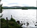
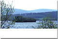
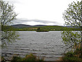
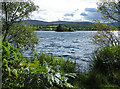
Nearby Images from Geograph Britain and Ireland:
©2005(licence)
©2005(licence)
©2009(licence)
©2011(licence)
©2011(licence)
The above images may not be of the site on this page, they are loaded from Geograph.
Please Submit an Image of this site or go out and take one for us!
Click here to see more info for this site
Nearby sites
Key: Red: member's photo, Blue: 3rd party photo, Yellow: other image, Green: no photo - please go there and take one, Grey: site destroyed
Download sites to:
KML (Google Earth)
GPX (GPS waypoints)
CSV (Garmin/Navman)
CSV (Excel)
To unlock full downloads you need to sign up as a Contributory Member. Otherwise downloads are limited to 50 sites.
Turn off the page maps and other distractions
Nearby sites listing. In the following links * = Image available
409m NW 312° Loch Kinord Cross Slab* Class III Pictish Cross Slab (NO44009978)
706m S 171° Kinord earth house* Souterrain (Fogou, Earth House) (NO444988)
706m N 7° Hut Circles at Old Kinord* Ancient Village or Settlement (NJ444002)
727m NNW 343° Old Kinord Ancient Village or Settlement (NJ441002)
1.3km NE 51° Monandavan Ring Cairn (NJ453003)
2.2km ENE 76° Knockenzie Ancient Village or Settlement (NJ465000)
3.8km ENE 69° Balnacraig Cairn Aberdeenshire Chambered Cairn (NJ47830082)
4.3km ESE 101° Ferrar Ancient Village or Settlement (NO485986)
4.9km ENE 76° Blue Cairn (Cairn)* Cairn (NJ49070059)
5.4km NNW 330° Milton of Whitehouse* Souterrain (Fogou, Earth House) (NJ417042)
5.4km WSW 246° Braehead Farm* Souterrain (Fogou, Earth House) (NO393974)
5.5km NNE 19° Corrachree* Class I Pictish Symbol Stone (NJ46160470)
5.6km WSW 249° Tullich* Class I Pictish Symbol Stone (NO390975)
5.9km NE 47° Tomnaverie* Stone Circle (NJ48650348)
6.2km NNE 14° Logie Coldstone Stone Circle (NJ459055)
6.3km NNE 25° Melgum Centre* Stone Circle (NJ471052)
6.4km NE 56° North Gellan Ancient Village or Settlement (NJ497030)
6.4km NNE 30° Waulkmill* Stone Circle (NJ47630500)
6.4km NNE 25° Melgum NW Stone Circle (NJ471053)
7.2km N 2° Milton of Migvie* Souterrain (Fogou, Earth House) (NJ44600668)
7.3km N 355° Migvie Cupmarked Stone* Rock Art (NJ4369606817)
7.3km N 354° Migvie Stone* Class II Pictish Symbol Stone (NJ4364706823)
7.5km NNE 29° Doune Hill Stone Circle (NJ480060)
7.5km NNW 334° Blue Cairn Circle* Stone Circle (NJ411063)
8.1km E 93° Image Wood* Stone Circle (NO524990)
View more nearby sites and additional images


 We would like to know more about this location. Please feel free to add a brief description and any relevant information in your own language.
 Wir möchten mehr über diese Stätte erfahren. Bitte zögern Sie nicht, eine kurze Beschreibung und relevante Informationen in Deutsch hinzuzufügen.
 Nous aimerions en savoir encore un peu sur les lieux. S'il vous plaît n'hesitez pas à ajouter une courte description et tous les renseignements pertinents dans votre propre langue.
 Quisieramos informarnos un poco más de las lugares. No dude en añadir una breve descripción y otros datos relevantes en su propio idioma.