<< Our Photo Pages >> Langourla menhir - Standing Stone (Menhir) in France in Bretagne:Côtes-D'Armor (22)
Submitted by Ben_Blackshaw on Sunday, 19 December 2004 Page Views: 3880
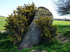
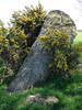
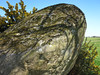
Neolithic and Bronze AgeSite Name: Langourla menhir Alternative Name: Menhir de la CoudreCountry: France
NOTE: This site is 1.586 km away from the location you searched for.
Département: Bretagne:Côtes-D'Armor (22) Type: Standing Stone (Menhir)
Nearest Town: Lamballe Nearest Village: Langourla
Latitude: 48.283400N Longitude: 2.4381W
Condition:
| 5 | Perfect |
| 4 | Almost Perfect |
| 3 | Reasonable but with some damage |
| 2 | Ruined but still recognisable as an ancient site |
| 1 | Pretty much destroyed, possibly visible as crop marks |
| 0 | No data. |
| -1 | Completely destroyed |
| 5 | Superb |
| 4 | Good |
| 3 | Ordinary |
| 2 | Not Good |
| 1 | Awful |
| 0 | No data. |
| 5 | Can be driven to, probably with disabled access |
| 4 | Short walk on a footpath |
| 3 | Requiring a bit more of a walk |
| 2 | A long walk |
| 1 | In the middle of nowhere, a nightmare to find |
| 0 | No data. |
| 5 | co-ordinates taken by GPS or official recorded co-ordinates |
| 4 | co-ordinates scaled from a detailed map |
| 3 | co-ordinates scaled from a bad map |
| 2 | co-ordinates of the nearest village |
| 1 | co-ordinates of the nearest town |
| 0 | no data |
Internal Links:
External Links:
I have visited· I would like to visit
johnstone visited on 4th Jun 2004 - their rating: Cond: 3 Amb: 3 Access: 4
")
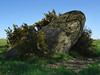
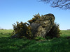
According to a nearby sign, the reason it leans to the side is that at the end of the 19th Century, "men dug to a depth of two metres in the hope of discovering treasure".
There appear to be other smaller stones of interest close by, but an electric fence (and bulls on my visit) may perturb one from closer inspection.
IMPORTANT NOTE: Positional co-ordinates scaled from a map source
You may be viewing yesterday's version of this page. To see the most up to date information please register for a free account.
")
")
Do not use the above information on other web sites or publications without permission of the contributor.
Nearby Images from Flickr
The above images may not be of the site on this page, but were taken nearby. They are loaded from Flickr so please click on them for image credits.
Click here to see more info for this site
Nearby sites
Click here to view sites on an interactive map of the areaKey: Red: member's photo, Blue: 3rd party photo, Yellow: other image, Green: no photo - please go there and take one, Grey: site destroyed
Download sites to:
KML (Google Earth)
GPX (GPS waypoints)
CSV (Garmin/Navman)
CSV (Excel)
To unlock full downloads you need to sign up as a Contributory Member. Otherwise downloads are limited to 50 sites.
Turn off the page maps and other distractions
Nearby sites listing. In the following links * = Image available
1.2km SSW 209° Menhir de Brigneul* Standing Stone (Menhir)
1.8km SW 227° Menhir de Perfaux E* Standing Stone (Menhir)
1.8km SW 226° Menhir de Perfaux A* Standing Stone (Menhir)
1.9km SW 220° Menhir de Perfaux D* Standing Stone (Menhir)
2.1km SW 227° Menhir de Perfaux C* Standing Stone (Menhir)
2.3km SW 229° Menhir de Perfaux B* Standing Stone (Menhir)
2.6km WSW 245° Martinais* Standing Stone (Menhir)
3.2km W 263° Allée couverte du Rocher (Saint-Jacut-du-Mené) Passage Grave
5.0km NNE 24° Roche aux Fées de la Brousse* Passage Grave
6.5km W 266° Allée Couverte de La Hautière Passage Grave
6.9km NW 325° Allée couverte des Meurtiaux* Passage Grave
7.4km N 349° Saint-Mirel deux menhirs* Standing Stone (Menhir)
7.6km NW 305° Pierres de Crokélien* Rock Outcrop
9.6km NW 304° Dolmen de Saint-Maudez Burial Chamber or Dolmen
10.8km WNW 304° Dolmen du Carouge* Burial Chamber or Dolmen
11.9km ESE 106° Menhir de la Glinaie Standing Stone (Menhir)
12.1km E 92° Allée Couverte du Bois de la Rabasse* Passage Grave
12.9km SSW 192° Pellionnaie menhir* Standing Stone (Menhir)
14.4km SSW 198° Allée Couverte de Ville-Menot* Passage Grave
15.8km SSW 199° Menhir de Bos Calers* Standing Stone (Menhir)
15.8km SSW 191° Menhir de Camblot* Standing Stone (Menhir)
16.0km S 186° Menhir de Chauchix* Standing Stone (Menhir)
16.2km W 272° Tumulus dit la Bosse du Diable Hillfort
16.4km S 181° Menhir de Bellouan* Standing Stone (Menhir)
17.1km W 266° Menhir du Saut Thébault* Standing Stone (Menhir)
View more nearby sites and additional images


 We would like to know more about this location. Please feel free to add a brief description and any relevant information in your own language.
 Wir möchten mehr über diese Stätte erfahren. Bitte zögern Sie nicht, eine kurze Beschreibung und relevante Informationen in Deutsch hinzuzufügen.
 Nous aimerions en savoir encore un peu sur les lieux. S'il vous plaît n'hesitez pas à ajouter une courte description et tous les renseignements pertinents dans votre propre langue.
 Quisieramos informarnos un poco más de las lugares. No dude en añadir una breve descripción y otros datos relevantes en su propio idioma.