


<< Text Pages >> Allée couverte du Rocher (Saint-Jacut-du-Mené) - Passage Grave in France in Bretagne:Côtes-D'Armor (22)
Submitted by TheCaptain on Sunday, 19 December 2004 Page Views: 2997
Neolithic and Bronze AgeSite Name: Allée couverte du Rocher (Saint-Jacut-du-Mené) Alternative Name: Le RocherCountry: France Département: Bretagne:Côtes-D'Armor (22) Type: Passage Grave
Nearest Town: Lamballe Nearest Village: Saint-Jacut-du-Mené
Latitude: 48.280000N Longitude: 2.4807W
Condition:
| 5 | Perfect |
| 4 | Almost Perfect |
| 3 | Reasonable but with some damage |
| 2 | Ruined but still recognisable as an ancient site |
| 1 | Pretty much destroyed, possibly visible as crop marks |
| 0 | No data. |
| -1 | Completely destroyed |
| 5 | Superb |
| 4 | Good |
| 3 | Ordinary |
| 2 | Not Good |
| 1 | Awful |
| 0 | No data. |
| 5 | Can be driven to, probably with disabled access |
| 4 | Short walk on a footpath |
| 3 | Requiring a bit more of a walk |
| 2 | A long walk |
| 1 | In the middle of nowhere, a nightmare to find |
| 0 | No data. |
| 5 | co-ordinates taken by GPS or official recorded co-ordinates |
| 4 | co-ordinates scaled from a detailed map |
| 3 | co-ordinates scaled from a bad map |
| 2 | co-ordinates of the nearest village |
| 1 | co-ordinates of the nearest town |
| 0 | no data |
Be the first person to rate this site - see the 'Contribute!' box in the right hand menu.
Internal Links:
External Links:
Allée Couverte in Côtes-d'Armor
You may be viewing yesterday's version of this page. To see the most up to date information please register for a free account.
Do not use the above information on other web sites or publications without permission of the contributor.
Nearby Images from Flickr
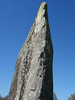
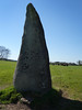
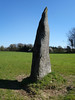
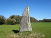

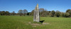
The above images may not be of the site on this page, but were taken nearby. They are loaded from Flickr so please click on them for image credits.
Click here to see more info for this site
Nearby sites
Click here to view sites on an interactive map of the areaKey: Red: member's photo, Blue: 3rd party photo, Yellow: other image, Green: no photo - please go there and take one, Grey: site destroyed
Download sites to:
KML (Google Earth)
GPX (GPS waypoints)
CSV (Garmin/Navman)
CSV (Excel)
To unlock full downloads you need to sign up as a Contributory Member. Otherwise downloads are limited to 50 sites.
Turn off the page maps and other distractions
Nearby sites listing. In the following links * = Image available
1.1km SE 131° Martinais* Standing Stone (Menhir)
1.8km SE 127° Menhir de Perfaux B* Standing Stone (Menhir)
1.9km ESE 123° Menhir de Perfaux C* Standing Stone (Menhir)
2.0km ESE 115° Menhir de Perfaux E* Standing Stone (Menhir)
2.0km ESE 116° Menhir de Perfaux A* Standing Stone (Menhir)
2.2km ESE 119° Menhir de Perfaux D* Standing Stone (Menhir)
2.7km ESE 104° Menhir de Brigneul* Standing Stone (Menhir)
3.2km E 83° Langourla menhir* Standing Stone (Menhir)
3.4km W 268° Allée Couverte de La Hautière Passage Grave
5.6km NNW 326° Pierres de Crokélien* Rock Outcrop
6.1km N 352° Allée couverte des Meurtiaux* Passage Grave
7.2km NE 46° Roche aux Fées de la Brousse* Passage Grave
7.5km NW 320° Dolmen de Saint-Maudez Burial Chamber or Dolmen
7.9km NNE 13° Saint-Mirel deux menhirs* Standing Stone (Menhir)
8.6km NW 318° Dolmen du Carouge* Burial Chamber or Dolmen
12.2km S 178° Pellionnaie menhir* Standing Stone (Menhir)
13.0km W 275° Tumulus dit la Bosse du Diable Hillfort
13.3km S 186° Allée Couverte de Ville-Menot* Passage Grave
14.0km W 267° Menhir du Saut Thébault* Standing Stone (Menhir)
14.7km S 188° Menhir de Bos Calers* Standing Stone (Menhir)
14.9km ESE 102° Menhir de la Glinaie Standing Stone (Menhir)
15.2km S 180° Menhir de Camblot* Standing Stone (Menhir)
15.2km E 90° Allée Couverte du Bois de la Rabasse* Passage Grave
15.6km S 175° Menhir de Chauchix* Standing Stone (Menhir)
16.2km S 170° Menhir de Bellouan* Standing Stone (Menhir)
View more nearby sites and additional images


 We would like to know more about this location. Please feel free to add a brief description and any relevant information in your own language.
 Wir möchten mehr über diese Stätte erfahren. Bitte zögern Sie nicht, eine kurze Beschreibung und relevante Informationen in Deutsch hinzuzufügen.
 Nous aimerions en savoir encore un peu sur les lieux. S'il vous plaît n'hesitez pas à ajouter une courte description et tous les renseignements pertinents dans votre propre langue.
 Quisieramos informarnos un poco más de las lugares. No dude en añadir una breve descripción y otros datos relevantes en su propio idioma.