


<< Our Photo Pages >> Saint-Mirel deux menhirs - Standing Stone (Menhir) in France in Bretagne:Côtes-D'Armor (22)
Submitted by TheCaptain on Sunday, 19 December 2004 Page Views: 3294
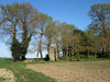
Neolithic and Bronze AgeSite Name: Saint-Mirel deux menhirsCountry: France Département: Bretagne:Côtes-D'Armor (22) Type: Standing Stone (Menhir)
Nearest Town: Lamballe Nearest Village: Plénée-Jugon
Latitude: 48.349000N Longitude: 2.4574W
Condition:
| 5 | Perfect |
| 4 | Almost Perfect |
| 3 | Reasonable but with some damage |
| 2 | Ruined but still recognisable as an ancient site |
| 1 | Pretty much destroyed, possibly visible as crop marks |
| 0 | No data. |
| -1 | Completely destroyed |
| 5 | Superb |
| 4 | Good |
| 3 | Ordinary |
| 2 | Not Good |
| 1 | Awful |
| 0 | No data. |
| 5 | Can be driven to, probably with disabled access |
| 4 | Short walk on a footpath |
| 3 | Requiring a bit more of a walk |
| 2 | A long walk |
| 1 | In the middle of nowhere, a nightmare to find |
| 0 | No data. |
| 5 | co-ordinates taken by GPS or official recorded co-ordinates |
| 4 | co-ordinates scaled from a detailed map |
| 3 | co-ordinates scaled from a bad map |
| 2 | co-ordinates of the nearest village |
| 1 | co-ordinates of the nearest town |
| 0 | no data |
Internal Links:
External Links:
I have visited· I would like to visit
johnstone visited on 4th Jun 2004 - their rating: Cond: 4 Amb: 3 Access: 3
JohnGinny have visited here
")
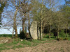
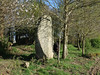
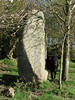
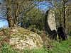
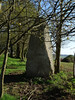
The first one (48.349N 2.45765W) measures 3.85 x 2.15 m.
The second one, south-east of number 1 (48.3482N 2.4555W) is called "La Pierre Longue", 4.45 x 2.5 m
Base Mérimée (Historic Monument)
IMPORTANT NOTE: Positional co-ordinates scaled from a map source
You may be viewing yesterday's version of this page. To see the most up to date information please register for a free account.
")
")
")
Do not use the above information on other web sites or publications without permission of the contributor.
Nearby Images from Flickr
The above images may not be of the site on this page, but were taken nearby. They are loaded from Flickr so please click on them for image credits.
Click here to see more info for this site
Nearby sites
Click here to view sites on an interactive map of the areaKey: Red: member's photo, Blue: 3rd party photo, Yellow: other image, Green: no photo - please go there and take one, Grey: site destroyed
Download sites to:
KML (Google Earth)
GPX (GPS waypoints)
CSV (Garmin/Navman)
CSV (Excel)
To unlock full downloads you need to sign up as a Contributory Member. Otherwise downloads are limited to 50 sites.
Turn off the page maps and other distractions
Nearby sites listing. In the following links * = Image available
3.0km WSW 238° Allée couverte des Meurtiaux* Passage Grave
4.4km SE 128° Roche aux Fées de la Brousse* Passage Grave
5.7km WSW 239° Pierres de Crokélien* Rock Outcrop
6.8km WSW 254° Dolmen de Saint-Maudez Burial Chamber or Dolmen
7.4km S 169° Langourla menhir* Standing Stone (Menhir)
7.6km W 260° Dolmen du Carouge* Burial Chamber or Dolmen
7.9km SSW 193° Allée couverte du Rocher (Saint-Jacut-du-Mené) Passage Grave
8.4km S 174° Menhir de Brigneul* Standing Stone (Menhir)
8.4km S 186° Martinais* Standing Stone (Menhir)
8.5km S 179° Menhir de Perfaux E* Standing Stone (Menhir)
8.6km S 179° Menhir de Perfaux A* Standing Stone (Menhir)
8.7km S 181° Menhir de Perfaux C* Standing Stone (Menhir)
8.7km S 179° Menhir de Perfaux D* Standing Stone (Menhir)
8.8km S 182° Menhir de Perfaux B* Standing Stone (Menhir)
9.3km SSW 213° Allée Couverte de La Hautière Passage Grave
12.0km NNE 16° Allée Couverte des Jeannetières* Passage Grave
12.1km NNE 25° Saint-Maleu menhir Standing Stone (Menhir)
13.5km NW 316° Allée Couverte du Champs des Caves* Passage Grave
13.6km NW 317° Allée Couverte dite de la Chaise-à-Margot Passage Grave
13.6km NW 317° Allée couverte dite de la Chaise-à-Margot* Passage Grave
13.6km NW 317° Menhir dit la Chaise-à-Margot* Standing Stone (Menhir)
13.8km NW 315° Allée couverte de la Bourdonnais* Passage Grave
14.4km N 9° Guihallon Menhir* Standing Stone (Menhir)
15.2km NNE 13° Allée Couverte des Kerves* Passage Grave
15.3km NNE 14° Alignement de la Forêt de Saint-Aubin Standing Stones
View more nearby sites and additional images


 We would like to know more about this location. Please feel free to add a brief description and any relevant information in your own language.
 Wir möchten mehr über diese Stätte erfahren. Bitte zögern Sie nicht, eine kurze Beschreibung und relevante Informationen in Deutsch hinzuzufügen.
 Nous aimerions en savoir encore un peu sur les lieux. S'il vous plaît n'hesitez pas à ajouter une courte description et tous les renseignements pertinents dans votre propre langue.
 Quisieramos informarnos un poco más de las lugares. No dude en añadir una breve descripción y otros datos relevantes en su propio idioma.