<< Other Photo Pages >> Kingsmead Quarry - Ancient Village or Settlement in England in Berkshire
Submitted by Andy B on Thursday, 08 February 2018 Page Views: 9788
Neolithic and Bronze AgeSite Name: Kingsmead QuarryCountry: England
NOTE: This site is 0.998 km away from the location you searched for.
County: Berkshire Type: Ancient Village or Settlement
Nearest Town: Windsor Nearest Village: Horton
Map Ref: TQ01707520
Latitude: 51.466641N Longitude: 0.537318W
Condition:
| 5 | Perfect |
| 4 | Almost Perfect |
| 3 | Reasonable but with some damage |
| 2 | Ruined but still recognisable as an ancient site |
| 1 | Pretty much destroyed, possibly visible as crop marks |
| 0 | No data. |
| -1 | Completely destroyed |
| 5 | Superb |
| 4 | Good |
| 3 | Ordinary |
| 2 | Not Good |
| 1 | Awful |
| 0 | No data. |
| 5 | Can be driven to, probably with disabled access |
| 4 | Short walk on a footpath |
| 3 | Requiring a bit more of a walk |
| 2 | A long walk |
| 1 | In the middle of nowhere, a nightmare to find |
| 0 | No data. |
| 5 | co-ordinates taken by GPS or official recorded co-ordinates |
| 4 | co-ordinates scaled from a detailed map |
| 3 | co-ordinates scaled from a bad map |
| 2 | co-ordinates of the nearest village |
| 1 | co-ordinates of the nearest town |
| 0 | no data |
Internal Links:
External Links:
I have visited· I would like to visit
Andy B has visited here

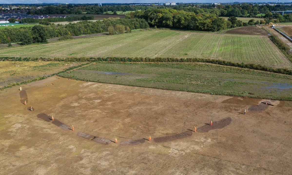
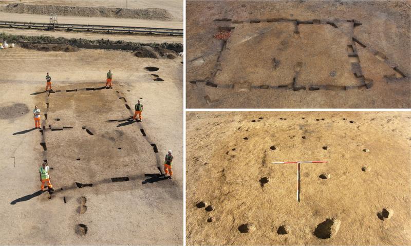
Previous news from this site: October 2013: Four early Neolithic houses, dated to 3700 BC, have been unearthed by archaeologists at Kingsmead Quarry, Horton in Berkshire. The discovery is unprecedented on a single site in England and challenges current understanding of how people lived more than 5,700 years ago. This rare find gives a unique opportunity to learn more about the earliest permanent settlements in prehistoric Britain and how such sites developed. At this time new practices were being adopted with people switching lifestyle from hunter-gather to settled farmer.
Few houses of this date have been found in England and rarely has more than one been found on a single site. These discoveries by excavators from Wessex Archaeology are key to enhancing the knowledge and understanding of this period nationally, and at a local level tell us more about the history of the area around the Rivers Colne and Thames near Windsor.
“Unfortunately only the ground plans have survived as any timber would have rotted away long age”. “However, we have a good idea of what these structures may have looked like from the many house finds in Ireland, from experimental work reconstructing prehistoric buildings, and (for wood working techniques) from timber-built walkways of the same date, such as the Sweet Track, that were found preserved in the peat deposits of the Somerset Levels”.
All the houses were rectangular in shape with the largest being 15 x 7 metres. Two were constructed out of upright oak planks set into foundation trenches, whilst the others were built using wooden posts.
Investigations at Kingsmead Quarry, Horton, Berkshire, operated by CEMEX have revealed a complex archaeological landscape and that people had used the area since the end of the last Ice Age, a period of over 12,000 years.
An excavation team from Wessex Archaeology has been investigating the site since 2003, with further excavation planned for the next two years. To date, over 28 hectares of the quarry have been examined.
Read more at Wessex Archaeology and also this page.
Note: Causewayed enclosure found in quarry near Windsor. Not sure if it's exactly this quarry but one in the close vicinity of this location. See the most recent comment on our page for more.
You may be viewing yesterday's version of this page. To see the most up to date information please register for a free account.

Do not use the above information on other web sites or publications without permission of the contributor.
Nearby Images from Geograph Britain and Ireland:

©2006(licence)

©2015(licence)

©2011(licence)

©2015(licence)

©2013(licence)
The above images may not be of the site on this page, they are loaded from Geograph.
Please Submit an Image of this site or go out and take one for us!
Click here to see more info for this site
Nearby sites
Key: Red: member's photo, Blue: 3rd party photo, Yellow: other image, Green: no photo - please go there and take one, Grey: site destroyed
Download sites to:
KML (Google Earth)
GPX (GPS waypoints)
CSV (Garmin/Navman)
CSV (Excel)
To unlock full downloads you need to sign up as a Contributory Member. Otherwise downloads are limited to 50 sites.
Turn off the page maps and other distractions
Nearby sites listing. In the following links * = Image available
788m NNW 331° Kingsmead Quarry Ancient Village or Settlement (TQ01307588)
2.7km SSE 166° Staines Enclosure* Causewayed Enclosure (TQ024726)
3.3km E 83° Heathrow* Cursus (TQ050757)
3.6km E 101° Stanwell Cursus* Cursus (TQ053746)
3.7km NE 48° Stanwell Cursus* Cursus (TQ044777)
4.0km SSE 162° Negen Stones Standing Stones (TQ030714)
4.0km ESE 106° St. Anne's Well (Stanwell)* Holy Well or Sacred Spring (TQ056742)
5.2km SE 136° Ashford Henge* Henge (TQ054715)
6.0km ESE 105° Bedfont Cursus (TQ075738)
7.0km NW 315° Montem mound Artificial Mound (SU9665880045)
7.5km S 175° The Nun's Well (Surrey)* Holy Well or Sacred Spring (TQ0247767756)
7.7km S 174° St Ann's Hill* Hillfort (TQ026676)
8.1km SSW 208° Leptis Magna (Virginia Waters)* Ancient Temple (SU980680)
8.4km NNW 328° Stoke Park Bowl Barrow* Round Barrow(s) (SU97038222)
8.5km SSE 166° Chertsey Museum Museum (TQ040670)
9.1km SE 140° Shepperton Henge* Henge (TQ07686832)
9.9km SSW 198° Barrowhills Round Barrow(s) (SU98866567)
10.3km SSW 195° Flutters Hill Barrow* Round Barrow(s) (SU99206516)
10.8km SSW 195° Longcross Barrow* Round Barrow(s) (SU99126466)
10.9km SW 218° Sunningdale Barrows Round Barrow(s) (SU952664)
11.4km WNW 291° Weir Bank Stud Farm Ancient Village or Settlement (SU90957900)
11.5km SSW 193° Chobham Common (1)* Misc. Earthwork (SU994639)
11.7km SSW 203° Albury Bottom Enclosure* Misc. Earthwork (SU97426430)
11.7km NW 325° Seven Ways Plain* Hillfort (SU94718466)
12.2km WSW 239° Bowledge Hill Bell Barrow* Round Barrow(s) (SU91336872)
View more nearby sites and additional images


 We would like to know more about this location. Please feel free to add a brief description and any relevant information in your own language.
 Wir möchten mehr über diese Stätte erfahren. Bitte zögern Sie nicht, eine kurze Beschreibung und relevante Informationen in Deutsch hinzuzufügen.
 Nous aimerions en savoir encore un peu sur les lieux. S'il vous plaît n'hesitez pas à ajouter une courte description et tous les renseignements pertinents dans votre propre langue.
 Quisieramos informarnos un poco más de las lugares. No dude en añadir una breve descripción y otros datos relevantes en su propio idioma.