Featured: Current Archaeology Book of the Year 2019!

Current Archaeology Book of the Year 2019!

Random Image


Heraclea

Explore Cornwall with the amazing Megalithic Portal smartphone app

Explore Cornwall with the amazing Megalithic Portal smartphone app

Who's Online

There are currently, 352 guests and 2 members online.

You are a guest. To join in, please register for free by clicking here

Sponsors

<< Our Photo Pages >> St Ann's Hill - Hillfort in England in Surrey

Submitted by SolarMegalith on Sunday, 21 July 2002  Page Views: 13147

Iron Age and Later PrehistorySite Name: St Ann's Hill Alternative Name: Oldbury Hill, Eldebury Hill
Country: England County: Surrey Type: Hillfort

Map Ref: TQ026676  Landranger Map Number: 176
Latitude: 51.398166N  Longitude: 0.526565W
Condition:
5Perfect
4Almost Perfect
3Reasonable but with some damage
2Ruined but still recognisable as an ancient site
1Pretty much destroyed, possibly visible as crop marks
0No data.
-1Completely destroyed
2 Ambience:
5Superb
4Good
3Ordinary
2Not Good
1Awful
0No data.
4 Access:
5Can be driven to, probably with disabled access
4Short walk on a footpath
3Requiring a bit more of a walk
2A long walk
1In the middle of nowhere, a nightmare to find
0No data.
4 Accuracy:
5co-ordinates taken by GPS or official recorded co-ordinates
4co-ordinates scaled from a detailed map
3co-ordinates scaled from a bad map
2co-ordinates of the nearest village
1co-ordinates of the nearest town
0no data
3

Internal Links:
External Links:

I have visited· I would like to visit

SolarMegalith visited on 1st Mar 2011 - their rating: Cond: 2 Amb: 4 Access: 4

St Ann's Hill
St Ann's Hill submitted by SolarMegalith : View for remains of the rampart and ditch (photo taken on March 2011). (Vote or comment on this photo)
Hillfort in Surrey

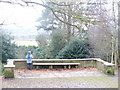
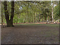
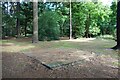
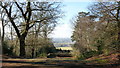
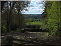
From SolarMegalith: Only western part of the hillfort on St Ann's Hill is in reasonable condition - the rampart, traces of the ditch and outer bank are still distinguishable. Various footpaths lead through this part of the hill, while on the Northern slope there's a holy well called The Nun's Well. Beside the Iron Age artefacts the excavations on top of the hill unearthed traces of Mesolithic occupation.
You may be viewing yesterday's version of this page. To see the most up to date information please register for a free account.


St Ann's Hill
St Ann's Hill submitted by SolarMegalith : Distinguishable line of the outer bank in western part of the hillfort (photo taken on March 2011). (Vote or comment on this photo)

St Ann's Hill
St Ann's Hill submitted by SolarMegalith : View from the rampart into remains of the ditch, with visible outer bank - view from the NE (photo taken on March 2011). (Vote or comment on this photo)

St Ann's Hill
St Ann's Hill submitted by SolarMegalith : View from the hillfort towards the North (photo taken on March 2011). (Vote or comment on this photo)

St Ann's Hill
St Ann's Hill submitted by SolarMegalith : Rampart and remains of the ditch in Western part of the hillfort - view from the SW (photo taken on March 2011). (Vote or comment on this photo)

Do not use the above information on other web sites or publications without permission of the contributor.

Nearby Images from Geograph Britain and Ireland:
TQ0267 : St Ann's Hill Viewpoint by Colin Smith
by Colin Smith
©2009(licence)
TQ0267 : St Ann's Hill by Alan Hunt
by Alan Hunt
©2012(licence)
TQ0267 : Platform near the Viewpoint by Des Blenkinsopp
by Des Blenkinsopp
©2023(licence)
TQ0267 : Trees on St.Ann's Hill by Peter Trimming
by Peter Trimming
©2009(licence)
TQ0267 : St Ann's Hill by Alan Hunt
by Alan Hunt
©2012(licence)

The above images may not be of the site on this page, they are loaded from Geograph.
Please Submit an Image of this site or go out and take one for us!


Click here to see more info for this site

Nearby sites

Click here to view sites on an interactive OS map

Key: Red: member's photo, Blue: 3rd party photo, Yellow: other image, Green: no photo - please go there and take one, Grey: site destroyed

Download sites to:
KML (Google Earth)
GPX (GPS waypoints)
CSV (Garmin/Navman)
CSV (Excel)

To unlock full downloads you need to sign up as a Contributory Member. Otherwise downloads are limited to 50 sites.


Turn off the page maps and other distractions

Nearby sites listing. In the following links * = Image available
 198m NW 323° The Nun's Well (Surrey)* Holy Well or Sacred Spring (TQ0247767756)
 1.5km ESE 114° Chertsey Museum Museum (TQ040670)
 3.8km N 7° Negen Stones Standing Stones (TQ030714)
 4.2km SW 235° Flutters Hill Barrow* Round Barrow(s) (SU99206516)
 4.2km WSW 244° Barrowhills Round Barrow(s) (SU98866567)
 4.5km SW 231° Longcross Barrow* Round Barrow(s) (SU99126466)
 4.6km W 276° Leptis Magna (Virginia Waters)* Ancient Temple (SU980680)
 4.8km NE 37° Ashford Henge* Henge (TQ054715)
 4.9km SW 222° Chobham Common (1)* Misc. Earthwork (SU994639)
 5.0km N 359° Staines Enclosure* Causewayed Enclosure (TQ024726)
 5.1km E 83° Shepperton Henge* Henge (TQ07686832)
 6.1km WSW 239° Albury Bottom Enclosure* Misc. Earthwork (SU97426430)
 7.2km NNE 26° St. Anne's Well (Stanwell)* Holy Well or Sacred Spring (TQ056742)
 7.5km W 262° Sunningdale Barrows Round Barrow(s) (SU952664)
 7.5km NNE 22° Stanwell Cursus* Cursus (TQ053746)
 7.7km N 354° Kingsmead Quarry* Ancient Village or Settlement (TQ01707520)
 7.8km SSE 167° Jack Temple Healing Centre* Modern Stone Circle etc (TQ045600)
 7.9km S 190° Horsell Common W* Barrow Cemetery (TQ01405980)
 7.9km S 188° Horsell Common E* Round Barrow(s) (TQ01615977)
 7.9km NE 39° Bedfont Cursus (TQ075738)
 8.3km SE 136° St George's Hill* Hillfort (TQ085618)
 8.4km N 352° Kingsmead Quarry Ancient Village or Settlement (TQ01307588)
 8.4km NNE 18° Heathrow* Cursus (TQ050757)
 8.9km SSW 206° Horsell Birch Natural Stone / Erratic / Other Natural Feature (SU98805956)
 8.9km S 173° Pyrford Stone* Marker Stone (TQ0382258782)
View more nearby sites and additional images

<< Drove Cottage Henge

Devil's Humps Barrows >>

Please add your thoughts on this site

Cures and Curses, Ritual and cult at holy wells

Cures and Curses, Ritual and cult at holy wells

Sponsors

Auto-Translation (Google)

Translate from English into:

"St Ann's Hill" | Login/Create an Account | 5 News and Comments
  
Go back to top of page    Comments are owned by the poster. We aren't responsible for their content.
Re: St Anne's Hill by Anonymous on Sunday, 18 June 2023
This is the sacred heart of The Great Hound in Mary Caine's Kingston Zodiac (her short documentary is on Youtube and easily found: this figure begins after her short intro. She was lovely, and would have enjoyed, I think, knowing that Her Late Majesty's Trainer of The Corgidom & world-famous Canine Psychologist Dr Roger Mugson is atop the hill, and the National Police Dog Training Centre halfway down. Avalon by Roxy Music was written here. The Temple of Friendship (listed) is here. The terraced landscaping is Georgian and awesome (and includes lovely American Redwood trees). The Druids clearly planted it back in the day: too many curious combinations to note, but noteworthy (e.g. Yew right next to other trees: a poisonous tree normally growing alone). Stones wonderful, too. Well worth the stop; hidden from The Madding Crowd by Merlin, I imagine, considering its power and centrality. Much more besides... Enjoy! Wonderful in the evenings, too: very, very friendly vibes. xjx
[ Reply to This ]

Re: St Anne's Hill by Andy B on Thursday, 18 August 2022
(User Info | Send a Message)
Lidar shading animation:

https://twitter.com/efpeeles/status/1559913639850680322
[ Reply to This ]

A good guide to visiting St. Ann's Hill by Andy B on Saturday, 07 August 2010
(User Info | Send a Message)
A good guide to visiting St. Ann's Hill
http://colintellsyouwheretogo.blog.co.uk/2005/08/11/st_ann_s_hill/

St. Ann's is a wooded hill of great beauty. It is almost 250 feet high and at one time had commanding views over the surrounding countryside. It is said that, on a clear day you could see St. Paul's Cathedral and, of course, the much closer Windsor Castle. Today many of the views are obscured by trees, but there is a good lookout from the beacon, where you can see aircraft taking off from Heathrow - and the new Terminal 5 and control tower.

The hill takes its name from a chapel built in 1334 and dedicated to St.Ann. Its original name was Eldebury (Oldbury) Hill and it is the site of a Bronze Age fort (around 300 BC). There are traces of old earthen defences. Unfortunately, the chapel became a ruin and almost all of it is now buried. A single wall remains, but that is within the private grounds of Reservoir Cottage.

One interesting feature that you can still see is the "Nun's Well", which is a spring emerging from under a brick arch. It is said that it never freezes, even in the coldest winter. There is also another spring in Monk's Grove, on the east side of the hill (towards Thorpe Road) - but I have not visited it.

His blog also has lots of other interesting walks in the area
http://colintellsyouwheretogo.blog.co.uk/2005/8/
[ Reply to This ]

Re: St Anne's Hill by Anonymous on Friday, 07 December 2007
I visit St Annes Hill on a very regular basis, and the whole site has some very interesting area's and a very dramatic history behind it. The energies there are dramatic, but good and the area known as the Dingle is especially so.

The whole hill is well worth a visit at any time of year, but remember to take only photographs and leave only footprints.

Blessings
Sian
[ Reply to This ]

Re: St Anne's Hill by Anonymous on Wednesday, 16 March 2005
I've visitted this place a couple of times.The atmosphere and energy there are very good and it is obviously a place of considerable power and significance At the foot of the hill is a pub called the Golden grove. I personally would not be surprised if the druids of the golden grove still inhabit the top of the hill which is an ideal place for a druid grove. I could almost see the spectral robed figures drifting ethereally amongst the trees. The well is a little neglected and not that easy to find. It's on the slopes on the western side of the hill. It's a domed brick structure which appears strangely womb like from the front. The waters are a little murky though the energy there is fine and there is evidence that a few people still come to light candles and honour the spirit of the holy waters. Well worth a visit. Take some flowers as an offering. chris street. 16.3.2005. starman@earth-stars.com
[ Reply to This ]

Your Name: Anonymous [ Register Now ]
Subject:


Add your comment or contribution to this page. Spam or offensive posts are deleted immediately, don't even bother

<<< What is five plus one as a number? (Please type the answer to this question in the little box on the left)
You can also embed videos and other things. For Youtube please copy and paste the 'embed code'.
For Google Street View please include Street View in the text.
Create a web link like this: <a href="https://www.megalithic.co.uk">This is a link</a>  

Allowed HTML is:
<p> <b> <i> <a> <img> <em> <br> <strong> <blockquote> <tt> <li> <ol> <ul> <object> <param> <embed> <iframe>

We would like to know more about this location. Please feel free to add a brief description and any relevant information in your own language.
Wir möchten mehr über diese Stätte erfahren. Bitte zögern Sie nicht, eine kurze Beschreibung und relevante Informationen in Deutsch hinzuzufügen.
Nous aimerions en savoir encore un peu sur les lieux. S'il vous plaît n'hesitez pas à ajouter une courte description et tous les renseignements pertinents dans votre propre langue.
Quisieramos informarnos un poco más de las lugares. No dude en añadir una breve descripción y otros datos relevantes en su propio idioma.