<< Our Photo Pages >> Taramakau Pa - Ancient Village or Settlement in New Zealand
Submitted by DrewParsons on Thursday, 25 June 2020 Page Views: 1205
Other ArchaeologySite Name: Taramakau PaCountry: New Zealand
NOTE: This site is 18.057 km away from the location you searched for.
Type: Ancient Village or Settlement
Nearest Town: Greymouth Nearest Village: Camerons
Latitude: 42.56026S Longitude: 171.143960E
Condition:
| 5 | Perfect |
| 4 | Almost Perfect |
| 3 | Reasonable but with some damage |
| 2 | Ruined but still recognisable as an ancient site |
| 1 | Pretty much destroyed, possibly visible as crop marks |
| 0 | No data. |
| -1 | Completely destroyed |
| 5 | Superb |
| 4 | Good |
| 3 | Ordinary |
| 2 | Not Good |
| 1 | Awful |
| 0 | No data. |
| 5 | Can be driven to, probably with disabled access |
| 4 | Short walk on a footpath |
| 3 | Requiring a bit more of a walk |
| 2 | A long walk |
| 1 | In the middle of nowhere, a nightmare to find |
| 0 | No data. |
| 5 | co-ordinates taken by GPS or official recorded co-ordinates |
| 4 | co-ordinates scaled from a detailed map |
| 3 | co-ordinates scaled from a bad map |
| 2 | co-ordinates of the nearest village |
| 1 | co-ordinates of the nearest town |
| 0 | no data |
Internal Links:
External Links:
I have visited· I would like to visit
DrewParsons has visited here
")
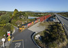
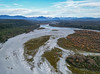
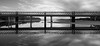
The Taramakau river estuary is the location of an ancient Māori pa site which was washed away in floods. The location given is for the descriptive sign by the Taramakau bridge half way from Greymouth to Hokitika.
You may be viewing yesterday's version of this page. To see the most up to date information please register for a free account.
")
")
Do not use the above information on other web sites or publications without permission of the contributor.
Nearby Images from Flickr


The above images may not be of the site on this page, but were taken nearby. They are loaded from Flickr so please click on them for image credits.
Click here to see more info for this site
Nearby sites
Click here to view sites on an interactive map of the areaKey: Red: member's photo, Blue: 3rd party photo, Yellow: other image, Green: no photo - please go there and take one, Grey: site destroyed
Download sites to:
KML (Google Earth)
GPX (GPS waypoints)
CSV (Garmin/Navman)
CSV (Excel)
To unlock full downloads you need to sign up as a Contributory Member. Otherwise downloads are limited to 50 sites.
Turn off the page maps and other distractions
Nearby sites listing. In the following links * = Image available
161.8km SE 132° Canterbury Museum* Museum
172.6km SE 133° Ōhinehou* Ancient Village or Settlement
192.5km NNE 25° Whakapoāi* Ancient Village or Settlement
200.2km SE 130° Okains Bay Maori and Colonial Museum* Museum
233.4km NE 36° Te Waikoropupu Springs* Holy Well or Sacred Spring
257.0km S 189° Takiroa Rock Art Site* Cave or Rock Shelter
258.5km S 188° Maerewhenua* Rock Art
310.8km S 185° Moeraki Beach Boulders (Otago)* Natural Stone / Erratic / Other Natural Feature
401.6km ENE 68° Stonehenge Aotearoa* Modern Stone Circle etc
420.5km ENE 65° Wairarapa Stone Circle Modern Stone Circle etc
424.5km NE 39° Te Uma a Tongahake Pa* Hillfort
424.8km NE 39° Turuturu Mokai Pa* Hillfort
425.6km NE 40° Tawhiti Museum* Museum
457.6km NNE 33° Whakawhitiwhiti Pā* Hillfort
460.9km NNE 33° Te Punga a Matori* Sculptured Stone
481.4km SSW 206° Southland Museum and Art Gallery* Museum
584.4km NE 48° Kaimanawa Wall* Natural Stone / Erratic / Other Natural Feature
602.3km NNE 32° Ruapuke Pa* Standing Stone (Menhir)
618.8km NE 43° Pohaturoa* Hillfort
697.0km NNE 28° Mangere Mountain Pa* Hillfort
699.0km NNE 27° Puketapapa Pa* Hillfort
700.9km NNE 28° Otahuhu Pa* Hillfort
702.0km NNE 27° Maungakiekie Pa* Hillfort
702.5km NNE 28° Cornwall Park Rongo Stone* Standing Stone (Menhir)
702.9km NNE 27° Epsom Modern Megalith* Modern Stone Circle etc
View more nearby sites and additional images


 We would like to know more about this location. Please feel free to add a brief description and any relevant information in your own language.
 Wir möchten mehr über diese Stätte erfahren. Bitte zögern Sie nicht, eine kurze Beschreibung und relevante Informationen in Deutsch hinzuzufügen.
 Nous aimerions en savoir encore un peu sur les lieux. S'il vous plaît n'hesitez pas à ajouter une courte description et tous les renseignements pertinents dans votre propre langue.
 Quisieramos informarnos un poco más de las lugares. No dude en añadir una breve descripción y otros datos relevantes en su propio idioma.