[< Gallery Home | Latest Images | Top 100 | Submit Picture >]
258331 Pictures
|
<< Previous Picture | Next Picture >>

| Submitted by | soulsurfer |
| Added | Sep 17 2012 |
| Hits | 502 |
| Votes | 0 |
Description
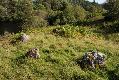
Difficult to find across boggy ground. Not even sure if this is it. can anyone confirm?
Posted Comments:
golux (2012-09-18)
According to RCAHMS, there are 2 possible circle here, both questionable.
One at NC 5822 0493 is described thus:
1. "The northern half of a stone circle measuring about 13 to 14ft in diameter the rest of which has been eroded by a burn. Four stones remain in situ, on the W, NW, NE and E, and range in height from 1ft 3ins to 2ft 3ins, standing with their faces along the line of the circumference. (OS (RDL) 2 July 1963)"
2. "Two of the stones are upright, but the other two are mere boulders, which may not have been set up. One of the uprights and one of the boulders are somewhat loose. There is some doubt that this is a pre-historic stone circle, and it may be a natural formation, wholly or in part. (OS (N K B) 28 July 1981)".
The other at NC 5824 0490 is described thus:
"The date and purpose of this structure remains uncertain. Of the stones shown in situ on the plan by Thom and Burl all are small and lack the "monolithic" appearance of a stone circle. They occur in the body of a wall ignored by Thom and Burl, which itself is very slight for a hut circle. It is overgrown with heather. The surrounding area shows no evidence of associated cultivation and it would appear to be generally unsuitable. (OS (N K B) 28 July 1981)".
I have marked the two locations on Google's aerial view, perhaps this will help match the photograph?
http://maps.google.co.uk/maps?q=58.010573,-4.400904&hl=en&num=1&t=h&z=18
http://maps.google.co.uk/maps?q=58.010846,-4.401264&hl=en&num=1&t=h&z=18
And the location given by The Portal is here -
http://maps.google.co.uk/maps?q=58.010852,-4.402449&hl=en&num=1&t=h&z=18
soulsurfer (2012-12-19)
Burl describes them as being 'within 6 metres' of the river. And these were the only stones I could find that close to river that resembled anything like a circle.
Maybe there would be more evidence in the winter when the grass isn't so tall.
Maybe there would be more evidence in the winter when the grass isn't so tall.
golux (2012-12-20)
"Maybe there would be more evidence in the winter when the grass isn't so tall." Time and again I have made the same comment when defeated by long grass/heather/gorse/etc, only to return in the winter and find it made even worse by the addition of standing water/snow/mud/etc!!!
To post comments first you must Register!
