| Author | Free LIDAR mapping data for England |
Andy B

Joined:
13-02-2001
Messages: 12302
from Surrey, UK
 OFF-Line OFF-Line
|  Posted 04-09-2015 at 22:34 Posted 04-09-2015 at 22:34
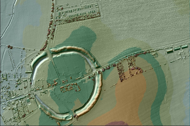
Dr Alison Matthew from the Environment Agency writes: For the past 17 years we have been capturing LIDAR (Light Detection & Ranging) data in England. LIDAR uses a laser to scan and map the landscape from above and is widely considered to be the best method for collecting very dense and accurate elevation data across the landscape.
[For the uninitiated, this LIDAR data can be used to spot previously unrecorded earthworks - or well known ones as seen below - but requires some Geo-hacking to get your head around - MegP Ed]
We use LIDAR to help the work of the Environment Agency in many ways, including creating flood models, assessing coastal change and analysing how land is used.
We now have an extensive archive of aerial LIDAR data covering nearly three quarters (72%) of England – the data mainly covers flood plains, coastal zones and urban areas. As technology has improved and costs have fallen, LIDAR data is now being used by just about everybody who works with maps. From local planners to archaeologists, farmers to ecologists, LIDAR data can inform their work.
In 2013, we made the data available for free for the first time for non-commercial use to anybody who wanted it. In that time more than one million km2 of data has been downloaded.
Following the Winter Floods 2014, we committed to ensuring our information is available, by publishing as much of it as possible as Open Data – free of charge and restrictions. From September 2015 all our LIDAR data will become Open Data and everyone will be able to use it for free.
We are releasing two LIDAR products under the Open Government Licence and you will be able to access these through Datashare.
http://www.geostore.com/environment-agency/WebStore?xml=environment-agency/xml/application.xml
By making the LIDAR data open to all, users will be able to access it free of charge, even for commercial use. We hope that by removing any cost barriers, our data will improve the quality of flood risk modelling and allow for the development of innovative tools and techniques to further benefit the environment.
[ This message was edited by: Andy B on 2015-09-04 22:39 ]
 Profile Profile
 Email Email
 Reply Reply
|
juamei

Joined:
28-11-2002
Messages: 47
from Buxton
OFF-Line
| Posted 05-09-2015 at 13:21
Is there a simple (or not so simple) how to?
Profile
Reply
|
Andy B
Joined:
13-02-2001
Messages: 12302
from Surrey, UK
OFF-Line
| Posted 05-09-2015 at 18:01
Hello Juamei, I've not tried this but apparently you can use a combination of QGIS (open-source GIS software)
http://www.qgis.org
and the Relief Visualisation toolbox
http://iaps.zrc-sazu.si/en/rvt#v
Relief Visualization Toolbox is a free application for computation of elevation data visualizations. The range of methods has been narrowed to include only the ones proven effective for detection of small scale features. It is easy to use and does not need installation or external software. Simplified results can be viewed in non-GIS software, e.g. in Windows Photo Viewer or in Preview for Mac users. The tool also supports elevation raster file data conversion. It is possible to convert all frequently used single band raster formats into GeoTIFF, ASCII gridded XYZ, Erdas Imagine file and ENVI file formats.
Info via http://www.pushingthesensors.com who are running a course on it next month in Swindon.
While searching I also found this
http://sourceforge.net/projects/livt/
Lidar Visualisation Toolbox provides an easy-to-use, stand-alone application to create visualisations from high-resolution airborne LIDAR-based digital elevation data. LiVT also includes tools like raster file creation from xyz point clouds. A few mouse clicks and some processing time should be enough to go from an xyz ASCII file to a grey-scale SVF image, an LRM map or a percentage map of cumulative visibility.
If anyone fancies having a go with this please share how you get on... Loads of previously unrecognised prehistoric earthworks have been discovered in this way.
One example (not added to the Portal as yet)
http://www.bbc.co.uk/news/uk-england-surrey-26006992
another one also called Black Down but in Somerset
http://www.forestry.gov.uk/fr/infd-7p6eyz
[ This message was edited by: Andy B on 2015-09-05 18:13 ]
Profile
Email
Reply
|
juamei
Joined:
28-11-2002
Messages: 47
from Buxton
OFF-Line
| Posted 05-09-2015 at 19:34
Cheers Andy. I think a night or two of intense reading is in order so I can understand the tech before trying to use the tools. I'll let you know how I get on!
[ This message was edited by: juamei on 2015-09-05 19:35 ]
Profile
Reply
|
ermine

Joined:
10-09-2002
Messages: 66
from Somerset
OFF-Line
| Posted 30-10-2015 at 23:40
Wow. That makes the old hamster in the computer spin the treadmill something rotten  QGIS will see some of that, I don't have the horsepower for the Slovenian visualisation stuff. QGIS will see some of that, I don't have the horsepower for the Slovenian visualisation stuff.
Still, I gave it a spin on Stonehenge

and it sort of works - interesting that the LIDAR picks up some of the punters, the stones and the cars
[ This message was edited by: ermine on 2015-10-30 23:42 ]
Profile
Reply
|
ermine
Joined:
10-09-2002
Messages: 66
from Somerset
OFF-Line
| Posted 31-10-2015 at 00:05
and indeed the Slovenian guys do show more archaeological features

at the cost of a less 3D effect to my eyes. The trick is don't install it in Program Files else it can't update its config file and barfs accordingly. Still makes the hamster sweat...
Profile
Reply
|
Andy B
Joined:
13-02-2001
Messages: 12302
from Surrey, UK
OFF-Line
| Posted 31-10-2015 at 15:51
Good stuff - thanks and welcome back Richard - good to hear from you!
[ This message was edited by: Andy B on 2015-10-31 16:24 ]
Profile
Email
Reply
|
ermine
Joined:
10-09-2002
Messages: 66
from Somerset
OFF-Line
| Posted 01-11-2015 at 14:44
Thanks, it's good to be back
That LIDAR stuff is really quite awesome, many thanks for the heads up - I chuntered though a few tiles of it for Avebury and it brings out the whole ritual landscape thing with the barrows - particularly at The Sanctuary - going for intervisibility with Avebury through what looks like a valley
Aerial images as such just don't really bring this out for me in the way this sort of processing does. The whole GIS thing seems to have come on a long way since I last looked at it. I'm impressed by the visualisation possibilities - may try it on the Stonehenge area sometime.
Profile
Reply
|
ainsloch

Joined:
04-08-2012
Messages: 177
from Belfast
OFF-Line
| Posted 02-11-2015 at 12:51
Now that is impressive, good work ermine! 
Profile
Reply
|
Orpbit

Joined:
24-06-2012
Messages: 1580
from Shropshire
OFF-Line
| Posted 03-11-2015 at 00:47
For those in the Marches border area (Shropshire/Powys) there's an online facility here:
http://www.aocarchaeology.com/openhills/lidar/viewer.html
Click the "+" button at top right to select base layers. you can also download a kml file to use with Google Earth. However, the opacity feature does not work using this route.
The LiDAR survey was undertaken as part of the Landscape Partnership Scheme, which holds a variety of events, including archaeology investigation with volunteers, led by archaeologists from Shropshire Council and CPAT (Clwyd-Powys Archaeology Trust). We've discovered some interesting features as a result!
The LiDAR base is very useful for creating presentation slides:

Profile
Reply
|
sem

Joined:
12-11-2003
Messages: 2819
from Bridgend,S.Wales
OFF-Line
| Posted 07-11-2015 at 18:55
Wales released it's own version on Monday and is available here -
http://lle.gov.wales/home?lang=en
To use on-line click on 'LiDAR Data Now Available' followed by the link to 'lle download portal" and finally on 'Preview'. Navigate the map as per Google and use the 'blue thingy' in the top right of the map to choose your base map and detail.
Looks good but it doesn't include in full localities I'm interested in (eg Carmarthan Fans) GGRRRRRRR!!
Profile
Reply
|
juamei
Joined:
28-11-2002
Messages: 47
from Buxton
OFF-Line
| Posted 26-12-2015 at 07:45
Us at the HJ have used the original set to create our Xmas competition this year:
https://heritageaction.wordpress.com/2015/12/23/christmas-competition/
Profile
Reply
|
Orpbit
Joined:
24-06-2012
Messages: 1580
from Shropshire
OFF-Line
| Posted 09-01-2016 at 11:46
Tim Daw has posted re - LiDAR. Don't want to steal his thunder so here's the link:
http://www.sarsen.org/2016/01/simple-how-to-view-free-lidar-mapping.html
Cheers,
Richard
Profile
Reply
|
TimDaw

Joined:
01-06-2013
Messages: 1
from United Kingdom
OFF-Line
| Posted 10-01-2016 at 09:57
Thanks for the link - I have borrowed it to update my simple guide, linked below. Cheers Tim
Profile
Reply
|
Orpbit
Joined:
24-06-2012
Messages: 1580
from Shropshire
OFF-Line
| Posted 15-03-2016 at 01:42
Stonehenge:
I've uploaded three files to Google Drive on this link:
https://drive.google.com/folderview?id=0B8iJm9sKwoLhSVF6STVsUzFZNTA&usp=sharing
All are from the DSM 1m tile set for 2006. Two are 3D verticals a little over 3MB each, one at vertical exaggeration (VE) x1, the other at VE x 2. These are just to get a feel for the relief of the wider landscape.
The third is pretty large at over 32MB, and as detailed as I can get it for such a large area with just one set of angles - azimuth 275° and vertical 0°.2. You can increase its resolution to a certain extent on line but you will need to download it to get the full res. and bigger - you can enlarge to 200% and more while retaining most of the detail.
I used QGIS. The images are for grid square SU14 only.
I downloaded the files from this link:
http://environment.data.gov.uk/ds/survey/#/survey
Click on the map for the OS grid square, and the available sets appear below, including the coverage within each square by clicking the "on/off" button.
2006 was a good year for DSM retrieval because of the drought conditions. I've compared a small area with other years and DTM renders. Unfortunately much of grid square is not available in DTM.
Does anyone know if any of the area has been surveyed at greater than 1m resolution?
I haven't bothered with any fancy colouring, as the 3D images are more than adequate for my purposes - for which you need a pair of red/cyan 3D glasses, although red/blue should work almost as fine.
Enjoy!
Richard
Profile
Reply
|
Energyman

Joined:
16-08-2004
Messages: 801
from Forest of Dean
OFF-Line
| Posted 15-03-2016 at 06:39

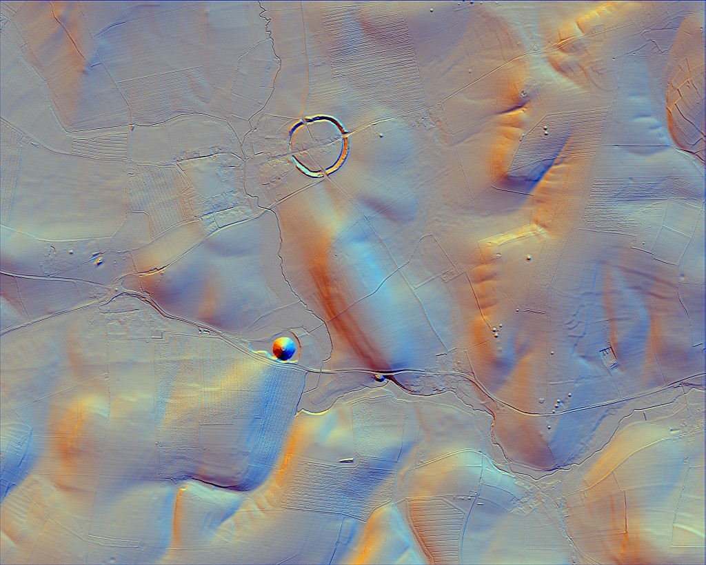
This is one I did of the Longstone area, Staunton at 1m tiles resolution, with hillshade and contours layers added.
Profile
Reply
|
Energyman
Joined:
16-08-2004
Messages: 801
from Forest of Dean
OFF-Line
| Posted 15-03-2016 at 06:56

And this is the same with road maps superimposed, at 50% transparency.
Profile
Reply
|
Energyman
Joined:
16-08-2004
Messages: 801
from Forest of Dean
OFF-Line
| Posted 15-03-2016 at 08:18
Actually, I should have said interpolation, not hillshade. You can tell it colour in the different contour heights. Very useful for working out sightlines in dense woodland, for instance.
The Welsh site is fantastic, Sem. Thanks for the link
Profile
Reply
|
Orpbit
Joined:
24-06-2012
Messages: 1580
from Shropshire
OFF-Line
| Posted 15-03-2016 at 16:44
Correction:
Apologies, the uploaded DSM files are actually for 2001. I annotated the images incorrectly, and never noticed. I've uploaded with corrected details!
Still working on Avebury.
Cheers,
Richard
Profile
Reply
|


