| Author | Preseli: A view from a satellite |
jonm

Joined:
12-07-2011
Messages: 2410
from UK
 OFF-Line OFF-Line
|  Posted 22-05-2015 at 14:53 Posted 22-05-2015 at 14:53
View from a satellite looking roughly westwards over a computer simulated landscape of the Preseli Mountains:

View from a satellite looking roughly eastwards over a computer simulated landscape of the Preseli Mountains:

Both of these pictures look fairly ordinary. But one of the two must be looking down: Feddau is below Eryr in the first picture and Eryr is below Feddau in the second picture. But if one is looking down, where is the horizon?
A while ago, I was asked if you can see the curvature of the Earth from a mountain?
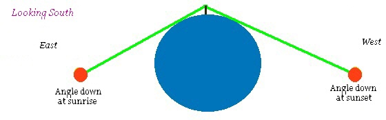
You can see a disk shape, but the disk you can see is not necessarily the curvature of the Earth: You could be on a flat disk. However, from two tall mountains of the same height, you can prove that the Earth is curved if you can see the horizon (below the slope of the other mountain) at sunrise: Sunrise or sunset is the time that the horizon can be precisely seen.
The angles involved are tiny: This experiment with mountain peaks only seems to work at a place called Preseli in Wales where two high mountain peaks are approximately of the same height, are aligned approximately east-west and have no obscured views for a long distance in either direction: The angles to the horizon at this particular height would show that Ireland and England would not exist if you are on a flat disk.
Any thoughts welcome!
 Profile Profile
 Email Email
 Reply Reply
|
aknifethatfellfromthesky

Joined:
01-05-2008
Messages: 175
from within and without
OFF-Line
| Posted 22-05-2015 at 16:50
the conspiracy sites on t'interweb are going crazy at the moment with flat earth stuff..apparantly (for no reason i can fathom) the powers that be! have decided to delude mankind with the idea of a speroidal earth in a heliocentric solar system
Profile
Reply
|
jonm
Joined:
12-07-2011
Messages: 2410
from UK
OFF-Line
| Posted 22-05-2015 at 17:44
Quote:
| the conspiracy sites on t'interweb are going crazy at the moment with flat earth stuff |
|
Simon Mayo asked me the question about whether you could see curvature from a tall mountain. He didn't sound convinced by the answer. Mind you, I didn't explain it well.
Perhaps the flat-earthers will have to ban Preseli as a holiday destination? Especially around about mid September: You should be able to see the effect in one day by starting at the neolithic mound placed on the top of Eryr (for sunrise) and then doing the short walk along the old path on the ridgeway to see sunset from the other neolithic mound placed at the high point of Feddau.
I was thinking of going myself: From Feddau you can follow the old path down past Carn Geodog and then a short walk north to a place called Castell Mawr. Just over the road, at a place called Rhos-y-Felin, there's the potential quarry that some archaeologists think may be the source for the bluestones of Stonehenge.
Jon
Profile
Email
Reply
|
sem

Joined:
12-11-2003
Messages: 2855
from Bridgend,S.Wales
OFF-Line
| Posted 23-05-2015 at 23:25
Hi Jon
Its an interesting idea that to my limited scientific knowledge could work, but...
How would the viewer know the mountains were the same height without more modern maps/GPS etc? It is possible to look "down" on something a mile away that is actually 100ft higher than you and this is only partly due to the earth's curvature. The brain's interpretation of "your" view is heavily modified by numerous other factors.
Best wishes
Sem
Profile
Reply
|
jonm
Joined:
12-07-2011
Messages: 2410
from UK
OFF-Line
| Posted 24-05-2015 at 14:43
Hi Sem
Quote:
| Its an interesting idea that to my limited scientific knowledge could work, but... How would the viewer know the mountains were the same height? |
|
Aha.. good point: They wouldn't! At low level, in places that you can see the horizon, the world appears to be a flat plane so high things are always above the horizon.
If a viewer were sitting on Foel Eryr at dawn during Autumn or Spring, she would see that the peak of Foel Feddau is above the rising sun.
If she then walked to Foel Feddau to see the setting sun, she would see that the sun sets below Foel Eryr.
Once she has seen this, she has a conundrum: How can two mountains both be higher than the other: Nearby, Foel Cwmcerwyn is obviously above both of them: She can see both Eryr and Feddau from Cwmcerwyn and can also check that there is nothing unusual about the horizon in either direction.
Because the two peaks are aligned roughly east-west, she can take others to see the same thing on the next few days.
It wouldn't take long before someone proposes that the world is not endless and instead a flat disc: But the disc idea is easily disproved because the angles down, although small, are too steep for the Earth to be a disk. If someone proposed that the world might be round like an apple, then that idea fits what can be observed at this one particular place.
Jon
(edit fixed the foel/carn error)
[ This message was edited by: jonm on 2015-05-25 07:30 ]
Profile
Email
Reply
|
jonm
Joined:
12-07-2011
Messages: 2410
from UK
OFF-Line
| Posted 25-05-2015 at 18:18
It's been pointed out to me that this curious and unlikely combination (two tall hills of the same height and with un-obscured views east and west over lower lying countryside) does exist at one other location:
Milk Hill (51° 22′ 47″N, 1°51′07″W) and Tan Hill (51° 22′ 47″ N, 1° 53′ 7″ W)
These hills are between Stonehenge and Avebury; just south of East Kennet long barrow. It is not known whether or not the summit of one or both of these hills is naturally created. These two hills are the highest points of the North Wessex Downs.
Many thanks to Harriet Vered for letting me know and Mick Harper for noticing the arrangement
[ This message was edited by: jonm on 2015-05-26 07:26 ]
Profile
Email
Reply
|
jonm
Joined:
12-07-2011
Messages: 2410
from UK
OFF-Line
| Posted 30-05-2015 at 10:07
Thought I'd add to this we've as discussed off-forum whether you could find the size of the earth at the two hills near Avebury: I don't think you can do it at that location so have put together a short summary of thoughts. Some of it has already been discussed on the forum but thought it worth the repeat:
Imagine you're standing on a hill looking over the world:
But at the high hills close to Avebury, the line of sight will graze the (shorter) hills of middle England (and also the hills of south west England):
This means that the estimate of the Earth's size will be too large:
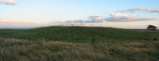
However, it might work in Preseli because there are views west over sea. The problem with Preseli is that the Feddau is slightly lower than Eryr. However, there's an old Neolithic mound on Eryr which is now about 15m diameter:
On Feddau, there's the remains of a much larger mound.
So it's possible that if these were re-built to their original sizes, or some other way made so that they were level, you could measure the size of the world from this location. (Looking from Eryr to Feddau, the lower parts of the Cambrian mountains get in the way so the back-sight method can't be used)
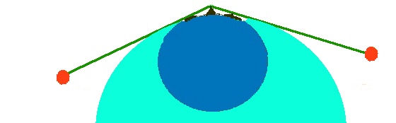
One way of measuring the size of the world more accurately is to use the 'back-sight' method. In this, clear views over sea (at least 60km) are needed in two opposing directions.
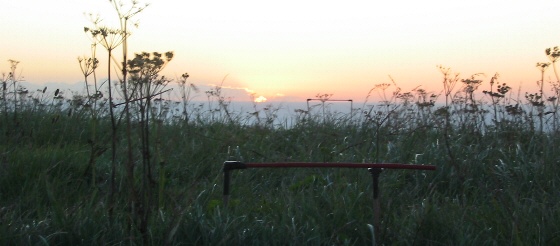
Here's a picture of how I did it: In this particular case, I found the ideal topographical spot and then did the experiment near to equinox. Using this method I could find the angle using sunrise (from one set) and then the angle to sunset looking back from the other bar: By measuring the height difference that the 'distant' bar is above the first, when the eye is level with the far bar and the horizon, the angle down can be found.
However, ideally a flat topped circular platform would work better: The 'platform' method doesn't need it to be done at equinox.
From the high point, it is then possible to work towards the coast using a water level and poles. For this 'station points' are needed along the route: Each one inter-visible from the other and with a relatively small level difference. From this, the height above sea level can be found (this how modern level surveys are done).
Once the angles down to sea level and the height are known, finding out the size of the world is a very simple calculation. My measurement using this system was about 5% out from what the size really is. Having said that, I didn't do it as accurately as it could have been done.
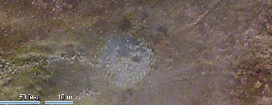
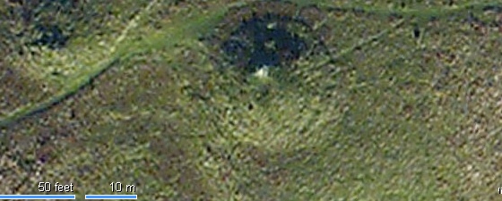
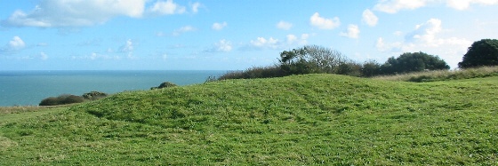
The place I did this experiment is the ideal topographical spot at the far end of the South Downs. This happens to have a very large flat topped circular Neolithic mound, about 2m high, with views over sea east and west:
Along that track-way to the coast, there are a series of smaller Neolithic platforms, each inter-visible with the next and each less than a 20m level difference (which happens to be nearly as high as the max height of trees that grow in this area):
These platforms work their way right to the coast (near Beachy Head)
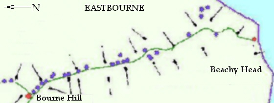
There's similar places along the south coast that you can do this if anyone tried to argue that the world is a weird curvy disk. The best locations for this also happen to have large diameter Neolithic mounds on top, so they are easy to find if you aren't using a GPS and topography maps.
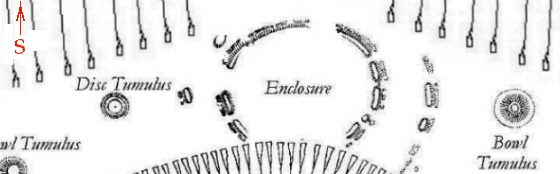
If the concept is difficult to get, an old Neolithic enclosure on the next hill along from Bourne Hill happens to have a few features that can be adapted to explain how all this works (and the maths) just by wandering about a bit:
(edit: added a forgotten graphic)
[ This message was edited by: jonm on 2015-05-30 11:23 ]
Profile
Email
Reply
|
DavidK

Joined:
17-10-2014
Messages: 1329
from Derbyshire
OFF-Line
| Posted 30-05-2015 at 18:33
Hi Jon
However, it might work in Preseli because there are views west over sea. The problem with Preseli is that the Feddau is slightly lower than Eryr. However, there's an old Neolithic mound on Eryr which is now about 15m diameter:
have you read Robin Heath's latest book? 'Proto Stonehenge in Wales'
The connection between Preseli and Avebury would appear to be very significant. Of course this is another post about the work of Professor Alexander Thom.
To understand what they were doing all roads lead back to Professor Thom and Knight and Butler and Robin Heath, and your work too!!, and of course Hewpop
To really understand what they were doing you need to walk the last two miles of the Ridgeway with binoculars focussed on Silbury hill. They did not need binoculars because Silbury hill was pure white.
read Thom, understand Megalithic
this helps
https://www.youtube.com/watch?v=ySKX0HOc7Zc
cheers
davek
[ This message was edited by: DavidK on 2015-05-30 18:34 ]
[ This message was edited by: DavidK on 2015-05-30 19:15 ]
[ This message was edited by: DavidK on 2015-05-30 19:17 ]
[ This message was edited by: DavidK on 2015-05-30 19:22 ]
[ This message was edited by: DavidK on 2015-05-30 20:34 ]
Profile
Reply
|
sem
Joined:
12-11-2003
Messages: 2855
from Bridgend,S.Wales
OFF-Line
| Posted 30-05-2015 at 22:52
Hi David
Could you explain what you mean by "To really understand what they were doing you need to walk the last two miles of the Ridgeway with binoculars focussed on Silbury hill."
I walked this for the first time last year and was totally puzzled by this conical thing sticking up over the horizon with no obvious alignments... until you get to The Sanctuary. Here it sits in a lovely 'V' on the horizon.
The Sanctuary is older than Silbury Hill, the ridgeway is older than The Sanctuary and the geological 'V' is older again. Such a conundrum eh?
Best wishes.
Profile
Reply
|
DavidK
Joined:
17-10-2014
Messages: 1329
from Derbyshire
OFF-Line
| Posted 31-05-2015 at 12:46
Hi Sem
thanks for asking this question. I read the thread you posted about Silbury Hill from the Ridgeway and last week we managed to get away for a few days. Since I read your thread I have been itching to go and see for myself and we walked from Barbury Castle. This is the last bit of the Ridgeway the sacred pathway. Just for the record it is a must do walk even if you are not interested in this stuff, it is spectacular from start to finish.
To put things in context I read 'A Lady in Waiting' by Roy Goutte, 'Avebury Cosmos' by Nicholas Mann and tried to read John North's book 'Stonehenge a New Interpretation' but just scanned the Avebury bits. Also Robin Heath's 'Proto SH in Wales'.
It was a mixed sunny n cloudy day and we had binoculars to see the red kites in particular. Once we got to Hackpen hill and could see Silbury the light on it was constantly changing and it is sandwiched between two hills just like the moon between two clouds. If it was white the effect would be quite stunning to anyone walking down towards the Sanctuary. Also if it was originally a dome it would appear even more moonlike but either way its position is most definitely influenced by the view from the Ridgeway.
'I walked this for the first time last year and was totally puzzled by this conical thing sticking up over the horizon with no obvious alignments... until you get to The Sanctuary. Here it sits in a lovely 'V' on the horizon.
The Sanctuary is older than Silbury Hill, the ridgeway is older than The Sanctuary and the geological 'V' is older again. Such a conundrum eh? '
You have put this perfectly, archaeologists have worked out the timelines and they are fairly well known based on their excavations but we don't know when the sites were laid out. The Aubrey circle was laid out before the station stone rectangle and that was laid out before the inner circle and there were hundreds of years elapsed between these events. the Cursus at SH has been dated 3600BC as have the Thornborough Henges.
AT SH this weekend I noticed four plastic covers lined up on the old car park, they must be planning to include these. They were dated way back. We don't know when Silbury was planned but it is obviously part of a sacred plan for the whole landscape including the Ridgeway.
The understanding is that you see how all the different sites are working together including WKLB, West Kennett Avenue and the Sanctuary and their relationship with Silbury Hill. There seems to be a unifying purpose behind the overall designs.
Google Earth is the best reference but you really need to go and see the contours to understand how things fit together so well.
On Google Earth to the west of the Ridgeway there is what could be described as a cursus and when you turn down the Wessex Ridgeway the field to the south shows crop markings that could support this idea. What is promising about the layout is that it is almost like the SH greater cursus turned 90 degrees and for Woodhenge substitute the Sanctuary.
When you go to the sites the scale that they were working to really hits you, this is what comes across really well in Professor Thom's books, he writes about it very matter of factly when it is actually quite jaw dropping. When you see the size of the Swindon stone its no wonder 'the vandals couldn't take the handles'.
Not really being into alignments it was necessary to refer to the 'Mann' and his book 'Avebury Cosmos'
On page 52 the azimuths are given and he (and archaaeologists) reckon the Cove at Avebury was built before the actual monument so from the largest stone at the cove to the Avebury cursus take a bearing of 49 degrees to hit the Ridgeway where the summer solstice sunrise occurred. It is marked by a copse of trees and when you get past the copse this is when you first see Silbury.
If you go down to 91 degrees you hit a track marking the equinox sunrise and then down to 129 degrees to hit the Winter solstice sunrise and the end of the cursus. So the two standstill points are at each end of the cursus.
So what you get is the Ridgeway taking you past the point of the Winter standstill of the Sun.
Your website explains this perfectly:
http://www.secretstones.co.uk/Perceptions/Annual-Sun-Movement
This is where the Moon (Silbury) comes in. As you move towards the Sanctuary Silbury just gets bigger and bigger till at the Sanctuary it is framed in all its glory, it is just magnificent.
We took the path off the Ridgeway before the Sanctuary to follow the path at the bottom end of the Cursus. You come out at the start of West Kennett Avenue. Instead of going up the Avenue walk up to the brow of the hill to obtain the most stunning view of Silbury.
My wife commented that the people who put the stones on the avenue were really happy and that there would have been music and children playing. She knows about these things.
Anyway to finish off some numbers to think about. On google measure the distance from just south of the Cove to Silbury Hill centre, it will be 0.92 miles. This is very significant. Soli-lunar time has a 92 beat minute if you have seen some of my other posts it is a 28 hour 52 minute time system based on Knight and Butler's 366x366x366 beat leap year. It is complicated but it mirrors the layout of SH and Avebury. So if Avebury is the Earth mother temple and we have soli-lunar time then Silbury can only represent one thing (actually that is wrong it represents many other things as well, they seem to have been happy and complicated people).
So 0.92 of a mile is 4857.6 feet and this is 92 x 52.8 feet which is 100th of a mile and also 5280 under the code reduced to units of 100th of a foot. It is also 368 x 13.2 feet and this is one megalithic metric foot which is the imperial foot x 11/10, (they were complicated). This all fits in with the idea in John North's book that they were rumoured to have laid out a model of their cosmos on Salisbury Plain. The maths certainly seems to support this idea with Old Sarum at the centre representing the Sun.
For what it is worth i think that there were two factors that led them to plan and build the monuments, one was being able to successfully predict eclipses and the other was a belief in reincarnation, these are not my ideas but they seem to be the best fit. If you believe in reincarnation you would be quite happy to work on multi generational projects. If they could predict eclipses then they could put on some amazing shows producing some very happy people who did not fear death but embraced it.
Perhaps the Ridgeway symbolises the passing through life into death when the departed spirit is picked up by the Moon and spiritual transfer effected at WKLB possibly a crematorium and birthing temple. Much more religion than ritual perhaps with proof of the sacred in the eclipse.
Sorry I have gone on a bit but it was a good holiday.
cheers
davek
[ This message was edited by: DavidK on 2015-06-01 14:54 ]
[ This message was edited by: DavidK on 2015-06-08 15:32 ]
Profile
Reply
|
DavidK
Joined:
17-10-2014
Messages: 1329
from Derbyshire
OFF-Line
| Posted 31-05-2015 at 14:45
Hi Jon
sorry for going off piste on this but having recently read Robin Heath's book your article seems to cover a lot of hot topics.
The distance between Avebury and SH is 91520 feet. Why is this so? Possibly because it represents one minute in time. If it does it sets the circumference of the Earth at 24960 miles.
If you try to wrap a line round the world using google earth it only lets you get halfway to 12430 miles making 24860 miles circumference.
This gives a difference of 100 miles. The question is did they round up the circumference to make it work? Hewpop has already picked up this and he is looking at circa 24900 based on the dimensions of the Great Pyramid.
They definitely hnew how to work it out and that the Earth like the Sun and Moon was a sphere, they were sailors.
It is intriguing that they also knew how to measure point to point distances accurately, we don't know how they did it only that they could do it. It must be fairly simple because they were practical people not prehistoric Einsteins.
Robin Heath seems to think is was trigonometry, using the Sun and Moon. They knew true North easily as you have evidenced, there must be a simple solution to this problem because their sites are laid out so incredibly accurately. It seems to be an engineering problem to solve.
cheers
davek
Profile
Reply
|
Feanor

Joined:
11-05-2011
Messages: 943
from Cape Cod Massachusetts, US
OFF-Line
| Posted 31-05-2015 at 14:53
I think you're on to something.
Once we lift our eyes from studying the minutia of individual sites and start looking at the whole, it's easy to see that those folks were extremely well-centered and had a comprehensive understanding of the world, all of its physical and metaphysical components, and their essential place within it.
Jon's work shows in studious detail the nuts and bolts of how much they knew, and why they needed to know it. Sem's hard work makes the essential connection with Wales, where much the same thing had been going on long before Avebury. Your observations strengthen the argument of how it was all then applied.
My own humble work demonstrates that all of the above was incorporated into one specific monument - which is why it was eventually made so fancy.
Instead of traipsing pupils across far and wide locations, they could simply be brought to Stonehenge where definitive proof of everything they understood could be illustrated in an afternoon.
But Jon's work clearly shows that they weren't just passive participants within these interwoven cosmological wonders. With the literal use of smoke and mirrors, they actually had mastery over it.
I like how all of the above independent presentations are made using at least 3 points of logic - even without the corroborating physical and spatial evidence. They all dovetail, then inexorably funnel to the same conclusion, making it extremely difficult to refute.
Extraordinary ...
We have now annoyed the Aliens. Prepare for invasion!
Best,
Neil
[ This message was edited by: Feanor on 2015-05-31 15:09 ]
Profile
Email
Reply
|
DavidK
Joined:
17-10-2014
Messages: 1329
from Derbyshire
OFF-Line
| Posted 01-06-2015 at 16:22
this is interesting for how they could have been using the amesbury archers protective wristplate and counting without using numbers.
https://www.youtube.com/watch?v=nenYna0jo1w
Profile
Reply
|
DavidK
Joined:
17-10-2014
Messages: 1329
from Derbyshire
OFF-Line
| Posted 02-06-2015 at 11:27
Jon said
'Once the angles down to sea level and the height are known, finding out the size of the world is a very simple calculation. My measurement using this system was about 5% out from what the size really is. Having said that, I didn't do it as accurately as it could have been done.'
This is really impressive again linking the actual sites to the result and using equipment that can only be described as megalithic, very simple and very effective. Thanks Jon another holiday destination on the list, never going abroad again at this rate!!
Extract from Wiki
'From these observations, measurements, and/or "known" facts, Eratosthenes concluded that, since the angular deviation of the sun from the vertical direction at Alexandria was also the angle of the subtended arc (see illustration), the linear distance between Alexandria and Syene was 1/50 of the circumference of the Earth which thus must be 50×5000 = 250,000 stadia or probably 25,000 geographical miles. The circumference of the Earth is 24,902 miles (40,075.16 km). Over the poles it is more precisely 40,008 km or 24,860 statute miles. The actual unit of measure used by Eratosthenes was the stadion. No one knows for sure what his stadion equals in modern units, but some say that it was the Hellenic 185-meter stadion.'
These calculations are intriguing because a stadia is 528 imperial feet based on the above. This is 176 yards
Translating to megalithic units 25000 miles is surprisingly 132000000 imperial feet. This is 4400000 imperial yards and if we multiply by 0.12 we get 5280000.
The numbers in miles for the Earth's circumference above have been confirmed as follows:
24902 in Hewpop's GT Pyramid workings.
24860+100 = 24960 miles is 91520 feet x 1440 this is the unit representing minutes in a circumference of the Earth and is the distance between SH and Avebury.
100 is a sacred number used in the design of Avebury based on Professor Thom's survey and workings.
Also 24960 x 3.66 recurring is 91520.
3.66 feet is 44 inches.
Finally the circumference of the Aubrey Circle is 132 megalithic rods based on a diameter of 42 megalthic rods as measured by Professor Thom.
So it represents the Earth 44 x 3 and the Moon 56.
The Stukeley circle also represents the Earth 52 and the Moon 56.
The diameter of the Stukeley circle is 5.6 feet x 52 = 291.20 imperial feet. Translating to the code where one foot represents 100 this is 29120 and multiplying by Pi 22/7 gives 91520 the distance between SH and Avebury.
Robin Heath has been using the Aubrey circle to predict eclipses at SH for the last 10 years apparently and has not got one wrong yet.
What is so impressive is that they had it more accurate than Eratosthenes, also is the 100 miles a deliberate adjustment.
Also Hewpop pulled me up on this measurement on his Gt Pyramid thread because he has it spot on of course.
As well as Jon's example another answer to how they did it could also be in the distance between the Thornborough Henges and the Lincoln Cathederal and Knight and Butler have done some work on this.
This is the longest flattest stretch of land in the UK.
cheers
davek
Profile
Reply
|
jonm
Joined:
12-07-2011
Messages: 2410
from UK
OFF-Line
| Posted 02-06-2015 at 18:13
Hi David
I don't know hardly anything about Heath, Thom or Knight and Butler's work so it's very difficult to comment.
Hi Neil
Quote:
| I like how all of the above independent presentations are made using at least 3 points of logic - even without the corroborating physical and spatial evidence. They all dovetail, then inexorably funnel to the same conclusion, making it extremely difficult to refute. |
|
Cheers Neil! The method I used to find the size of the Earth was similar to that of Biruni and it's been commented that the maths are quite complex:
http://en.wikipedia.org/wiki/History_of_geodesy#Biruni. Biruni also used relatively complex instruments to work out the size of the world. I'm not entirely sure why he used such complex maths.
However, if you're using the back-sight method, the only equipment needed is a bit of logic, two sticks and the ability to count. Here's how to do it:
Imagine you are looking from the hill downwards: You have what we would call an angle. However the angle is also a 'slope' and we'll call that slope 1/N:
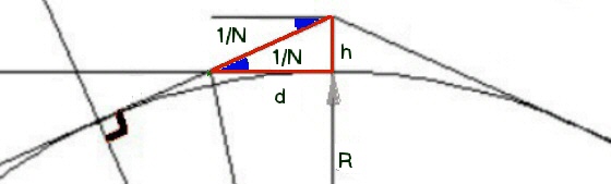
Where the line of sight grazes the earth, there will be a second triangle to the intersection point. This slope we'll also note as 1/N: Because the angles are very small, we can say that the distances along both the horizontal baseline and the sight-line are virtually identical (shown as 'd').
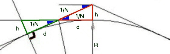
Expanding out, these sets of triangles form a large triangle. This also has the slope of almost exactly 1/N ('almost' because there is a miniscule error introduced by us saying that the lines are identical)
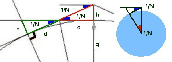
From this, the 'equation' for the size of the world is just a multiple of the slopes:
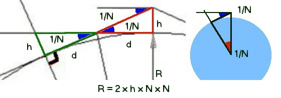
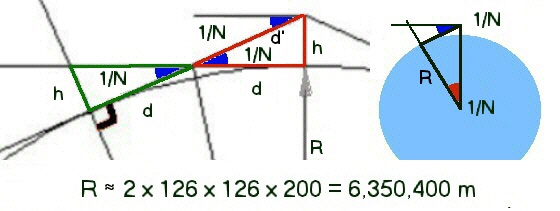
Now looking at our sticks, we have measured two heights A and B. If we put those sticks together and then count how many of them fit into the line D, we will have found N/2. When I did the experiment, N was 130 but if you did it a bit more accurately than I did it, you would get about 126 at Bourne Hill. It doesn't matter what base system you use as any system will do.
It doesn't need any form of measurement scale to do any of this!
Now you feed that into your equation. In this example I've used base 10 because that's what we use today, but any method of counting will do. If you don't know how to multiply numbers, this is what will take the time:
Looking back at the figures I got on the day, I was 6% out. Based on tests on my own eyesight, it should be possible to determine the size of the world to an accuracy of less than 1%. One of the things that would introduce the biggest potential error is the question of whether to do the height measurement (which is the only part that needs some sort of unit of measurement) at high tide, low tide or the average.
Jon
Profile
Email
Reply
|
jonm
Joined:
12-07-2011
Messages: 2410
from UK
OFF-Line
| Posted 03-06-2015 at 09:52
Only realised after writing up the explanation above. All you need to measure the size of the world at Bourne is two sticks. The next hill (Coombe) has the layout with the large circle:
(50° 47' 54"N, 0° 14' 02"E)
The hill after that is Windover Hill. This is the one that has this figure, no-one knows how old, placed on its north face:
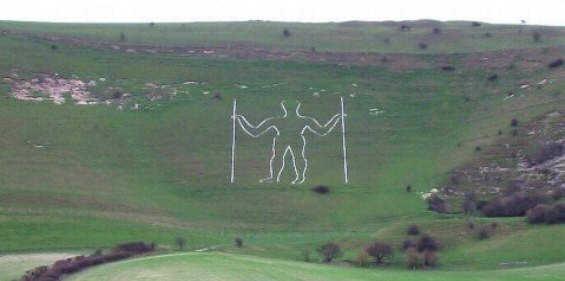
(50° 48' 36"N, 0° 11' 36"E)
Urgent update to book required perhaps?
(edit fixed hilll name)
[ This message was edited by: jonm on 2015-06-03 09:58 ]
Profile
Email
Reply
|
Runemage

Joined:
15-07-2005
Messages: 4009
from UK
OFF-Line
| Posted 03-06-2015 at 11:36
Fabulous, guys!
It's been suggested that the chalk figure called the Long Man of Wilmington was some form of ancient surveyor, maybe you've all now confirmed that and explained what he did.
Rune 
Profile
Reply
|
davidmorgan

Joined:
23-11-2006
Messages: 3123
from UK
OFF-Line
| Posted 03-06-2015 at 16:43
Where are the sticks in the diagram?
Profile
Reply
|
jonm
Joined:
12-07-2011
Messages: 2410
from UK
OFF-Line
| Posted 03-06-2015 at 18:03
Hi David
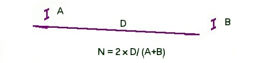
The sticks are used to find dimensions A and B: You get a stick, mark off the height and then do the same at sunset. Join the marked off lengths of the two sticks and you have "A+B". In my case, they were little more than twigs (I just wanted to check that it worked so used a very short baseline).
I've been thinking of putting together an unedited compendium of all the geocentric explanations for Neolithic monuments. One way that's been suggested is to then publish each individual set via peer review. But peer review would be a very slow and cumbersome project: There is a large bulk of coincidences and I am not sure that it would be possible.
In the medium term, it would probably be best to expand the book (no need for the peer review process). But I have a very heavy workload on at the moment and don't like to publish stuff unless it's been through my checking mill. Another good way is to publish ideas as they stand via the blog or the Portal. This has the advantage of getting the ideas out but in a hap-hazard sort of way (still takes quite a bit of time). However, it's exceptionally dis-jointed if you haven't read all the threads (and almost everything needs a graphic to explain it).
Difficult to know what to do with all of this.
Cheers
Jon
Profile
Email
Reply
|
davidmorgan
Joined:
23-11-2006
Messages: 3123
from UK
OFF-Line
| Posted 03-06-2015 at 18:14
Where are A and B in the diagram? I only see h, d, R and 1/N.
Profile
Reply
|

