 with our Megalithic Portal iPhone app")


<< Our Photo Pages >> Devil's Punchbowl - Rock Outcrop in England in Isles of Scilly
Submitted by Bladup on Monday, 30 May 2022 Page Views: 382
Natural PlacesSite Name: Devil's PunchbowlCountry: England County: Isles of Scilly Type: Rock Outcrop
Map Ref: SV88270760
Latitude: 49.887247N Longitude: 6.34147W
Condition:
| 5 | Perfect |
| 4 | Almost Perfect |
| 3 | Reasonable but with some damage |
| 2 | Ruined but still recognisable as an ancient site |
| 1 | Pretty much destroyed, possibly visible as crop marks |
| 0 | No data. |
| -1 | Completely destroyed |
| 5 | Superb |
| 4 | Good |
| 3 | Ordinary |
| 2 | Not Good |
| 1 | Awful |
| 0 | No data. |
| 5 | Can be driven to, probably with disabled access |
| 4 | Short walk on a footpath |
| 3 | Requiring a bit more of a walk |
| 2 | A long walk |
| 1 | In the middle of nowhere, a nightmare to find |
| 0 | No data. |
| 5 | co-ordinates taken by GPS or official recorded co-ordinates |
| 4 | co-ordinates scaled from a detailed map |
| 3 | co-ordinates scaled from a bad map |
| 2 | co-ordinates of the nearest village |
| 1 | co-ordinates of the nearest town |
| 0 | no data |
Internal Links:
External Links:
")
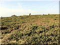
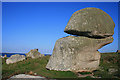
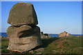
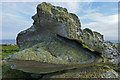
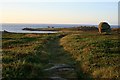
The Devil's Punchbowl, a massive Outcrop on Wingletang Down, I'm sure the Ancient folk would have been fascinated by this amazing outcrop, As the top stone would probably have looked to them like it had been placed there and the bottom stone just doesn't look like it should still be standing at all, It seems that this outcrop was some sort of focal point as there are many cairns to the South and East of it
You may be viewing yesterday's version of this page. To see the most up to date information please register for a free account.
")
")
")
")
Do not use the above information on other web sites or publications without permission of the contributor.
Nearby Images from Geograph Britain and Ireland:
©2012(licence)
©2008(licence)
©2008(licence)
©2013(licence)
©2012(licence)
The above images may not be of the site on this page, they are loaded from Geograph.
Please Submit an Image of this site or go out and take one for us!
Click here to see more info for this site
Nearby sites
Key: Red: member's photo, Blue: 3rd party photo, Yellow: other image, Green: no photo - please go there and take one, Grey: site destroyed
Download sites to:
KML (Google Earth)
GPX (GPS waypoints)
CSV (Garmin/Navman)
CSV (Excel)
To unlock full downloads you need to sign up as a Contributory Member. Otherwise downloads are limited to 50 sites.
Turn off the page maps and other distractions
Nearby sites listing. In the following links * = Image available
104m SSE 160° Wingletang Down* Cairn (SV883075)
301m NW 306° St Warna's Well* Holy Well or Sacred Spring (SV8803707792)
581m WNW 301° The Nag's Head* Rock Outcrop (SV87790793)
657m SSW 201° Curiosities of St Agnes* Natural Stone / Erratic / Other Natural Feature (SV8807)
697m WNW 283° Troy Town Maze* Turf Maze (SV876078)
793m WNW 281° Castella Downs Field System* Ancient Village or Settlement (SV875078)
841m ENE 61° Clapper of Works* Chambered Cairn (SV8903407959)
976m ENE 61° Carn of Works* Chambered Tomb (SV8915408021)
1.0km NNE 31° Carn Valla Chambered Cairn* Chambered Cairn (SV88850846)
1.0km NNE 27° Obadiah's Barrow* Burial Chamber or Dolmen (SV88800850)
1.1km NNE 16° Tol Tuppens Bronze Age Settlement* Ancient Village or Settlement (SV88650867)
1.2km NE 38° Old Man of Gugh* Standing Stone (Menhir) (SV89040848)
1.2km NNE 28° The Bow Chambered Cairn* Chambered Cairn (SV88890861)
1.2km NNE 23° Kittern Hill* Burial Chamber or Dolmen (SV88790867)
1.2km NNE 22° Kittern Rock Chambered Cairn* Chambered Cairn (SV88780868)
1.2km NNE 31° Gugh Chambered Cairn* Chambered Cairn (SV88950859)
1.2km NE 44° Kimbra Cairn* Cairn (SV89160841)
3.3km NE 54° Peninnis Head Settlement* Ancient Village or Settlement (SV91050938)
3.3km NE 51° Peninnis Head Boundary Misc. Earthwork (SV90970952)
3.3km NNE 30° Porthcressa Barrow Cemetery (SV901104)
3.4km NE 53° Peninnis Head* Cairn (SV911095)
3.6km NNE 33° Isles of Scilly Museum* Museum (SV904105)
3.6km NE 37° Buzza Hill* Burial Chamber or Dolmen (SV90601038)
3.6km NE 37° King Edward's Tower Chambered Cairn* Chambered Cairn (SV90631038)
3.8km NE 43° Carn Gwavel Souterrain (Fogou, Earth House) (SV910102)
View more nearby sites and additional images


 We would like to know more about this location. Please feel free to add a brief description and any relevant information in your own language.
 Wir möchten mehr über diese Stätte erfahren. Bitte zögern Sie nicht, eine kurze Beschreibung und relevante Informationen in Deutsch hinzuzufügen.
 Nous aimerions en savoir encore un peu sur les lieux. S'il vous plaît n'hesitez pas à ajouter une courte description et tous les renseignements pertinents dans votre propre langue.
 Quisieramos informarnos un poco más de las lugares. No dude en añadir una breve descripción y otros datos relevantes en su propio idioma.