<< Our Photo Pages >> Arminghall Henge - Henge in England in Norfolk
Submitted by Andy B on Monday, 12 September 2022 Page Views: 36896
Neolithic and Bronze AgeSite Name: Arminghall HengeCountry: England
NOTE: This site is 1.527 km away from the location you searched for.
County: Norfolk Type: Henge
Map Ref: TG240060 Landranger Map Number: 134
Latitude: 52.605571N Longitude: 1.306670E
Condition:
| 5 | Perfect |
| 4 | Almost Perfect |
| 3 | Reasonable but with some damage |
| 2 | Ruined but still recognisable as an ancient site |
| 1 | Pretty much destroyed, possibly visible as crop marks |
| 0 | No data. |
| -1 | Completely destroyed |
| 5 | Superb |
| 4 | Good |
| 3 | Ordinary |
| 2 | Not Good |
| 1 | Awful |
| 0 | No data. |
| 5 | Can be driven to, probably with disabled access |
| 4 | Short walk on a footpath |
| 3 | Requiring a bit more of a walk |
| 2 | A long walk |
| 1 | In the middle of nowhere, a nightmare to find |
| 0 | No data. |
| 5 | co-ordinates taken by GPS or official recorded co-ordinates |
| 4 | co-ordinates scaled from a detailed map |
| 3 | co-ordinates scaled from a bad map |
| 2 | co-ordinates of the nearest village |
| 1 | co-ordinates of the nearest town |
| 0 | no data |
Internal Links:
External Links:
I have visited· I would like to visit
ravinbex would like to visit
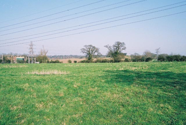
Sus visited on 12th Nov 2022 - their rating: Cond: 1 Amb: 4 Access: 4 It was exciting to stand in the middle and turn around and see it. My husband and mother walked in the opposite direction convinced that this was not the circle, so some imagination required. When I was there the earth had been turned over, possibly from recent excavation but you could make out the slight depression in the landscape and the rings around the ground.
There isn't much parking, we pulled in and parked parallel to the road.
JohnLindsay visited on 1st Jul 2012 - their rating: Cond: 1 Amb: 2 Access: 3 Went past the site in teh 587 bus, two and hour, then got off in Trowse. There isn't much to see in the field but you aren't far from Whitlinghan country park. someone has already mentioned white horse lane, and I'm taken by whit lin ge ham... in the country park there is a thoroughly misleading poster board. One wonders whether something more couldn't be made of all this. Nothing in Norwich Museum which only starts with the Romans from what I can see. The 587 bus continues, or comes from, Caister, so you can add in some Roman stuff. The Pastscape article has bibliography, so to the UEA library for a read.
AngieLake have visited here
Average ratings for this site from all visit loggers: Condition: 1 Ambience: 3 Access: 3.5
The site was visited by O. G. S. Crawford a week later who pronounced it to be the Norwich Woodhenge but it was not until 1935 that it was first excavated, by Grahame Clark.
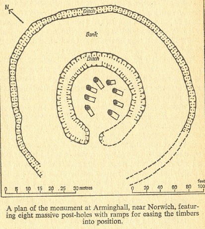
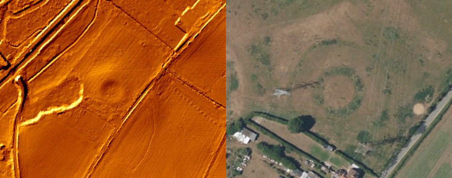
His work established that two circular rings were ditches, the outer one 1.5 m deep and the inner one 2.3 m deep, with indications of a bank that once stood between them. The pits in the middle were postholes for timbers that would have been almost 1 m in diameter. The site dates to the Neolithic, with a radiocarbon date of 3650-2650 Cal BC (4440±150) from charcoal from a post-pit. The henge is orientated on the mid-winter sunset, which when viewed from the henge, sets down the slope of nearby high ground, Chapel Hill.
Fragments from a sacred landscape found in the vicinity, in Ber Street, Norwich - see comment below
Page originally by Vicky.
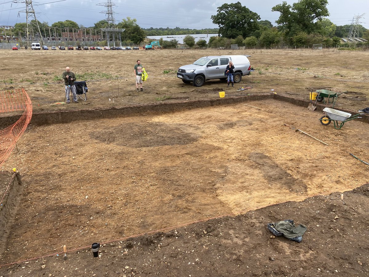
Note: Arminghall Henge is being excavated at present - the photo shows massive post holes being uncovered again for the first time since 1935
You may be viewing yesterday's version of this page. To see the most up to date information please register for a free account.

Do not use the above information on other web sites or publications without permission of the contributor.
Click here to see more info for this site
Nearby sites
Key: Red: member's photo, Blue: 3rd party photo, Yellow: other image, Green: no photo - please go there and take one, Grey: site destroyed
Download sites to:
KML (Google Earth)
GPX (GPS waypoints)
CSV (Garmin/Navman)
CSV (Excel)
To unlock full downloads you need to sign up as a Contributory Member. Otherwise downloads are limited to 50 sites.
Turn off the page maps and other distractions
Nearby sites listing. In the following links * = Image available
2.7km NNW 343° Norwich Castle Museum and Art Gallery* Museum (TG231085)
2.7km W 274° Eaton Heath Barrow Cemetery (TG21280605)
2.8km SSW 204° Venta Icenorum* Ancient Village or Settlement (TG230034)
8.4km NW 304° Roundwell* Holy Well or Sacred Spring (TG168104)
9.1km WNW 290° St Walstan's Well* Holy Well or Sacred Spring (TG15350878)
10.7km SSW 204° Tasburgh Fort* Hillfort (TM201960)
13.0km NNW 338° Horsford Woods Barrow Cemetary* Barrow Cemetery (TG18571780)
14.1km WSW 254° St Thomas's Well (Wymondham)* Holy Well or Sacred Spring (TG10550146)
16.6km NW 320° Alderford Common Barrow Round Barrow(s) (TG12751828)
17.4km NW 316° The Warren Barrow Round Barrow(s) (TG11371798)
18.0km SSE 147° Broome Heath Long Barrow Long Barrow (TM344913)
18.0km SSE 148° Broome Heath Enclosure Ancient Village or Settlement (TM34289115)
18.5km SE 131° Stockton Stone* Standing Stone (Menhir) (TM386946)
18.9km SSE 152° Druid's Stone (Bungay)* Natural Stone / Erratic / Other Natural Feature (TM3366689739)
19.6km NNW 344° Maiden's Head* Holy Well or Sacred Spring (TG178246)
20.7km SSE 165° Flixton Park Quarry Timber Circle (TM303863)
21.9km NNE 32° Devil's Ditch Ancient Trackway (TG347252)
22.9km NW 321° Pettywell* Holy Well or Sacred Spring (TG086230)
23.4km E 97° Burgh Castle Shore Fort Stone Fort or Dun (TG474044)
24.4km ESE 104° Bell Hill Round Barrow(s) (TG480010)
24.4km ESE 104° Mill Hill Round Barrow(s) (TG480010)
26.3km WNW 289° St Withburga's Well* Holy Well or Sacred Spring (TF9865213305)
27.5km WSW 238° Gallows Hill Tumulus Round Barrow(s) (TM01419019)
28.0km SW 232° Vikings Mound* Artificial Mound (TM02678781)
28.1km NNE 15° Knapton* Modern Stone Circle etc (TG3020433448)
View more nearby sites and additional images


 We would like to know more about this location. Please feel free to add a brief description and any relevant information in your own language.
 Wir möchten mehr über diese Stätte erfahren. Bitte zögern Sie nicht, eine kurze Beschreibung und relevante Informationen in Deutsch hinzuzufügen.
 Nous aimerions en savoir encore un peu sur les lieux. S'il vous plaît n'hesitez pas à ajouter une courte description et tous les renseignements pertinents dans votre propre langue.
 Quisieramos informarnos un poco más de las lugares. No dude en añadir una breve descripción y otros datos relevantes en su propio idioma.