<< Text Pages >> Chislehurst Caves - Cave or Rock Shelter in England in Kent
Submitted by coldrum on Thursday, 01 May 2008 Page Views: 8102
Natural PlacesSite Name: Chislehurst CavesCountry: England County: Kent Type: Cave or Rock Shelter
Nearest Town: Chislehurst
Map Ref: TQ433695
Latitude: 51.406428N Longitude: 0.058895E
Condition:
| 5 | Perfect |
| 4 | Almost Perfect |
| 3 | Reasonable but with some damage |
| 2 | Ruined but still recognisable as an ancient site |
| 1 | Pretty much destroyed, possibly visible as crop marks |
| 0 | No data. |
| -1 | Completely destroyed |
| 5 | Superb |
| 4 | Good |
| 3 | Ordinary |
| 2 | Not Good |
| 1 | Awful |
| 0 | No data. |
| 5 | Can be driven to, probably with disabled access |
| 4 | Short walk on a footpath |
| 3 | Requiring a bit more of a walk |
| 2 | A long walk |
| 1 | In the middle of nowhere, a nightmare to find |
| 0 | No data. |
| 5 | co-ordinates taken by GPS or official recorded co-ordinates |
| 4 | co-ordinates scaled from a detailed map |
| 3 | co-ordinates scaled from a bad map |
| 2 | co-ordinates of the nearest village |
| 1 | co-ordinates of the nearest town |
| 0 | no data |
Internal Links:
External Links:
I have visited· I would like to visit
kthdsn visited on 23rd Aug 2015 - their rating: Cond: 5 Amb: 5 Access: 5
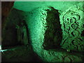
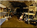
Chalk caves said to have been dug over a period of 8000 years.
There is a well said to have been in use in Roman times deep within the cave network. Visitors will need to take the guided tour of Chiselhurst caves.
Open to the public.
Chislehurst Caves web page
You may be viewing yesterday's version of this page. To see the most up to date information please register for a free account.
Do not use the above information on other web sites or publications without permission of the contributor.
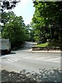
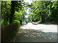
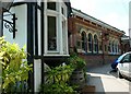
Nearby Images from Geograph Britain and Ireland:
©2010(licence)
©2010(licence)
©2017(licence)
©2017(licence)
©2010(licence)
The above images may not be of the site on this page, they are loaded from Geograph.
Please Submit an Image of this site or go out and take one for us!
Click here to see more info for this site
Nearby sites
Key: Red: member's photo, Blue: 3rd party photo, Yellow: other image, Green: no photo - please go there and take one, Grey: site destroyed
Download sites to:
KML (Google Earth)
GPX (GPS waypoints)
CSV (Garmin/Navman)
CSV (Excel)
To unlock full downloads you need to sign up as a Contributory Member. Otherwise downloads are limited to 50 sites.
Turn off the page maps and other distractions
Nearby sites listing. In the following links * = Image available
1.1km NE 50° Mound Chislehurst Artificial Mound (TQ441702)
2.3km ESE 102° Hobling Well Holy Well or Sacred Spring (TQ456691)
2.5km W 263° St Blaise's well Holy Well or Sacred Spring (TQ40806911)
4.4km SE 135° Bromley Museum Museum (TQ465665)
4.5km SW 225° Hussey Well* Holy Well or Sacred Spring (TQ402662)
5.0km SSW 212° Hayes Common 2 Ancient Village or Settlement (TQ408652)
5.5km SW 221° Hayes Common 1* Ancient Village or Settlement (TQ398652)
5.7km SSW 196° Caesar's Well* Holy Well or Sacred Spring (TQ419640)
5.7km SSW 193° Caesar's Camp (Keston) Hillfort (TQ422639)
5.9km E 81° Chalk Wood Denehole Ancient Mine, Quarry or other Industry (TQ491706)
6.6km SSW 198° Warbank Ancient Village or Settlement (TQ414632)
7.1km ENE 75° Joyden's Wood Ancient Village or Settlement (TQ501715)
7.3km E 81° Stonebill Green Deneholes Ancient Mine, Quarry or other Industry (TQ505709)
7.6km N 6° Shrewsbury Tumulus* Round Barrow(s) (TQ439771)
7.6km ENE 66° Cavey's Springs Deneholes Ancient Mine, Quarry or other Industry (TQ502728)
8.2km NW 316° Hilly Fields Stone Circle* Modern Stone Circle etc (TQ374752)
8.7km NNE 18° Winn's Common Tumulus* Round Barrow(s) (TQ457779)
8.8km NNW 331° Greenwich Park Barrows* Barrow Cemetery (TQ3883677128)
11.3km E 81° Holy well (Hawley) Holy Well or Sacred Spring (TQ545715)
11.4km WSW 238° Croham Hurst* Round Barrow(s) (TQ338632)
11.4km ESE 112° Eynsford Stone* Natural Stone / Erratic / Other Natural Feature (TQ540655)
11.8km ENE 70° Dartford Borough Museum* Museum (TQ5431773920)
12.2km E 92° Sutton At Hone Enclosures Ancient Village or Settlement (TQ555694)
13.0km W 269° Pollards Hill Hillfort (TQ303688)
13.3km SSW 205° Nore Hill Bronze Age Enclosure Misc. Earthwork (TQ380573)
View more nearby sites and additional images


 We would like to know more about this location. Please feel free to add a brief description and any relevant information in your own language.
 Wir möchten mehr über diese Stätte erfahren. Bitte zögern Sie nicht, eine kurze Beschreibung und relevante Informationen in Deutsch hinzuzufügen.
 Nous aimerions en savoir encore un peu sur les lieux. S'il vous plaît n'hesitez pas à ajouter une courte description et tous les renseignements pertinents dans votre propre langue.
 Quisieramos informarnos un poco más de las lugares. No dude en añadir una breve descripción y otros datos relevantes en su propio idioma.