

<< Other Photo Pages >> The Goldstone - Natural Stone / Erratic / Other Natural Feature in England in East Sussex
Submitted by coldrum on Friday, 30 April 2021 Page Views: 11135
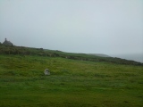
Natural PlacesSite Name: The GoldstoneCountry: England County: East Sussex Type: Natural Stone / Erratic / Other Natural Feature
Nearest Town: Brighton Nearest Village: Hove
Map Ref: TQ2868306021
Latitude: 50.839418N Longitude: 0.173776W
Condition:
| 5 | Perfect |
| 4 | Almost Perfect |
| 3 | Reasonable but with some damage |
| 2 | Ruined but still recognisable as an ancient site |
| 1 | Pretty much destroyed, possibly visible as crop marks |
| 0 | No data. |
| -1 | Completely destroyed |
| 5 | Superb |
| 4 | Good |
| 3 | Ordinary |
| 2 | Not Good |
| 1 | Awful |
| 0 | No data. |
| 5 | Can be driven to, probably with disabled access |
| 4 | Short walk on a footpath |
| 3 | Requiring a bit more of a walk |
| 2 | A long walk |
| 1 | In the middle of nowhere, a nightmare to find |
| 0 | No data. |
| 5 | co-ordinates taken by GPS or official recorded co-ordinates |
| 4 | co-ordinates scaled from a detailed map |
| 3 | co-ordinates scaled from a bad map |
| 2 | co-ordinates of the nearest village |
| 1 | co-ordinates of the nearest town |
| 0 | no data |
Internal Links:
External Links:
I have visited· I would like to visit
lucasn visited on 29th Jan 2022 - their rating: Cond: 4 Amb: 3 Access: 5
stolinskie visited on 1st Jan 2020 - their rating: Cond: 2 Amb: 3 Access: 5
Twistytwirly visited - their rating: Cond: 2 Amb: 3 Access: 5
Average ratings for this site from all visit loggers: Condition: 2.67 Ambience: 3 Access: 5
")
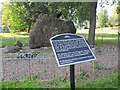
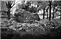
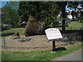
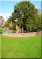
The big stone is set in a smaller ring of stones and was believed to be an ancient druids' meeting point. However, during the early part of the 19th century the contemporary farmer, whose land the stone was on, got so incensed by the continual visits of the 19th century druids and supporters he buried it in a secret location. This remained so until 1900 when it was finally located, dug up, and in 1906 placed in its current spot in the newly opened Hove Park.
Note: Megaliths and Folklore in Brighton and Hove by Kevin Groves: The Goldstone and Hove Circle, see the comments on our page along with more from 3rd Stone Issues 41 and 42 which are now scanned and available to read
You may be viewing yesterday's version of this page. To see the most up to date information please register for a free account.
")
Do not use the above information on other web sites or publications without permission of the contributor.
coldrum has found this location on Google Street View:
Nearby Images from Geograph Britain and Ireland:
©2023(licence)
©2007(licence)
©2009(licence)
©2007(licence)
©2009(licence)
The above images may not be of the site on this page, they are loaded from Geograph.
Please Submit an Image of this site or go out and take one for us!
Click here to see more info for this site
Nearby sites
Key: Red: member's photo, Blue: 3rd party photo, Yellow: other image, Green: no photo - please go there and take one, Grey: site destroyed
Download sites to:
KML (Google Earth)
GPX (GPS waypoints)
CSV (Garmin/Navman)
CSV (Excel)
To unlock full downloads you need to sign up as a Contributory Member. Otherwise downloads are limited to 50 sites.
Turn off the page maps and other distractions
Nearby sites listing. In the following links * = Image available
1.2km SE 141° Hove Barrow* Round Barrow(s) (TQ2948105096)
1.3km SSW 203° Hove Museum and Art Gallery* Museum (TQ282048)
2.3km WSW 251° St. Leonards Church Sarsens Natural Stone / Erratic / Other Natural Feature (TQ26560524)
3.0km SE 126° Brighton Museum and Art Gallery* Museum (TQ312043)
3.1km W 277° Church Hill Standing Stones Natural Stone / Erratic / Other Natural Feature (TQ2554506318)
3.9km ENE 65° Hollingbury* Hillfort (TQ322078)
4.5km ESE 108° Whitehawk* Causewayed Enclosure (TQ33030477)
4.9km WNW 283° Rest And Be Thankful Marker Stone (TQ239070)
5.3km NW 320° Adder Bottom Tumulus Round Barrow(s) (TQ252100)
5.4km NW 311° Tenant Hill Fields System Misc. Earthwork (TQ245095)
5.6km NE 44° Rocky Clump* Natural Stone / Erratic / Other Natural Feature (TQ325101)
5.7km NW 318° Fulking Hill Tumulus 2 Round Barrow(s) (TQ24771011)
5.7km WNW 303° Tenant Hill Tumulus Round Barrow(s) (TQ238090)
5.7km NNW 333° Devil's Dyke (West Sussex)* Hillfort (TQ2597311088)
5.9km NE 46° Pudding Bag Tumuli Barrow Cemetery (TQ328102)
6.1km WNW 292° Thunders Barrow Misc. Earthwork (TQ230082)
6.1km WNW 291° Thunders Barrow Field System Misc. Earthwork (TQ229081)
6.1km NW 322° Fulking Hill Tumulus 1* Round Barrow(s) (TQ248108)
6.2km WNW 293° Thundersbarrow Hill Hillfort (TQ229083)
6.2km NNW 346° North Hill Tumuli Barrow Cemetery (TQ270120)
6.6km NE 48° Stanmer Stones* Natural Stone / Erratic / Other Natural Feature (TQ3350010600)
6.7km NNE 27° Standean* Natural Stone / Erratic / Other Natural Feature (TQ316121)
7.0km NW 317° Edburton Hill Motte and Bailey* Artificial Mound (TQ23771102)
7.2km ENE 70° Stones around Falmer Village Pump Natural Stone / Erratic / Other Natural Feature (TQ354087)
7.3km NW 315° Edburton Hill Tumulus* Round Barrow(s) (TQ23381100)
View more nearby sites and additional images


 We would like to know more about this location. Please feel free to add a brief description and any relevant information in your own language.
 Wir möchten mehr über diese Stätte erfahren. Bitte zögern Sie nicht, eine kurze Beschreibung und relevante Informationen in Deutsch hinzuzufügen.
 Nous aimerions en savoir encore un peu sur les lieux. S'il vous plaît n'hesitez pas à ajouter une courte description et tous les renseignements pertinents dans votre propre langue.
 Quisieramos informarnos un poco más de las lugares. No dude en añadir una breve descripción y otros datos relevantes en su propio idioma.