<< Our Photo Pages >> Grims Mound - Round Barrow(s) in England in Lincolnshire
Submitted by DavidRaven on Thursday, 13 July 2006 Page Views: 9119
Neolithic and Bronze AgeSite Name: Grims Mound Alternative Name: Grim's MoundCountry: England County: Lincolnshire Type: Round Barrow(s)
Nearest Town: Louth Nearest Village: Burgh on Bain
Map Ref: TF23258693
Latitude: 53.364877N Longitude: 0.149247W
Condition:
| 5 | Perfect |
| 4 | Almost Perfect |
| 3 | Reasonable but with some damage |
| 2 | Ruined but still recognisable as an ancient site |
| 1 | Pretty much destroyed, possibly visible as crop marks |
| 0 | No data. |
| -1 | Completely destroyed |
| 5 | Superb |
| 4 | Good |
| 3 | Ordinary |
| 2 | Not Good |
| 1 | Awful |
| 0 | No data. |
| 5 | Can be driven to, probably with disabled access |
| 4 | Short walk on a footpath |
| 3 | Requiring a bit more of a walk |
| 2 | A long walk |
| 1 | In the middle of nowhere, a nightmare to find |
| 0 | No data. |
| 5 | co-ordinates taken by GPS or official recorded co-ordinates |
| 4 | co-ordinates scaled from a detailed map |
| 3 | co-ordinates scaled from a bad map |
| 2 | co-ordinates of the nearest village |
| 1 | co-ordinates of the nearest town |
| 0 | no data |
Internal Links:
External Links:
I have visited· I would like to visit
Catrinm visited on 24th Oct 2021 - their rating: Cond: 5 Amb: 4 Access: 4 Very well defined mound just off the road
Bladup have visited here
")
You may be viewing yesterday's version of this page. To see the most up to date information please register for a free account.
")
")
Do not use the above information on other web sites or publications without permission of the contributor.
coldrum has found this location on Google Street View:
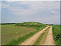
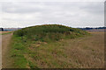
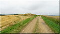
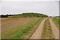
Nearby Images from Geograph Britain and Ireland:
©2008(licence)
©2007(licence)
©2021(licence)
©2007(licence)
©2008(licence)
The above images may not be of the site on this page, they are loaded from Geograph.
Please Submit an Image of this site or go out and take one for us!
Click here to see more info for this site
Nearby sites
Key: Red: member's photo, Blue: 3rd party photo, Yellow: other image, Green: no photo - please go there and take one, Grey: site destroyed
Download sites to:
KML (Google Earth)
GPX (GPS waypoints)
CSV (Garmin/Navman)
CSV (Excel)
To unlock full downloads you need to sign up as a Contributory Member. Otherwise downloads are limited to 50 sites.
Turn off the page maps and other distractions
Nearby sites listing. In the following links * = Image available
2.8km SW 226° Burgh on Bain* Long Barrow (TF21298497)
3.4km SSW 214° Burgh Top* Round Barrow(s) (TF21458406)
7.8km SE 129° Tathwell Long Barrow* Long Barrow (TF29458225)
8.0km NW 313° Bully Hill (Tealby)* Round Barrow(s) (TF17279227)
8.5km N 350° Hoe Hill Long Barrow* Long Barrow (TF215953)
8.8km NW 322° Lud well (Stainton-Le-Vale)* Holy Well or Sacred Spring (TF17629376)
9.5km NNW 347° Ash Hill Long Barrow* Long Barrow (TF20889612)
9.7km E 92° Julian Bower Turf Maze (Louth) Turf Maze (TF32938677)
10.7km ESE 115° Bully Hills* Barrow Cemetery (TF33128272)
10.9km WNW 302° Walesby All Saints church carvings* Sculptured Stone (TF1382892388)
13.5km S 187° Baumber Cursus* Cursus (TF22067350)
13.7km NW 315° Hills Brough* Long Barrow (TF1337396415)
14.4km WSW 257° Wickenby Ancient Village or Settlement (TF0928883432)
14.8km NNW 345° Ash Holt Long Barrow* Long Barrow (TA1898001112)
15.4km S 174° West Ashby Henge (TF25347168)
16.7km SE 125° Beacon Plantation Long Barrow* Long Barrow (TF372776)
17.9km SSE 158° Newell Spring* Holy Well or Sacred Spring (TF3041770472)
18.3km NW 323° Syfer Spring Holy Well or Sacred Spring (TA117012)
18.3km NW 323° Holy Well (Caistor) Holy Well or Sacred Spring (TA1172501229)
19.6km SW 228° Barlings Well* Holy Well or Sacred Spring (TF08937347)
19.7km NNW 328° Fonaby Stone* Standing Stones (TA123033)
22.0km N 6° Toot Hill Round Barrow* Round Barrow(s) (TA24800888)
22.2km NNE 19° Beacon Hill Barrow (Cleethorpes)* Round Barrow(s) (TA2994408098)
22.3km SE 133° Spellow Hills* Long Barrow (TF4014272239)
22.9km N 353° Ragged Spring (Healing) Holy Well or Sacred Spring (TA199096)
View more nearby sites and additional images


 We would like to know more about this location. Please feel free to add a brief description and any relevant information in your own language.
 Wir möchten mehr über diese Stätte erfahren. Bitte zögern Sie nicht, eine kurze Beschreibung und relevante Informationen in Deutsch hinzuzufügen.
 Nous aimerions en savoir encore un peu sur les lieux. S'il vous plaît n'hesitez pas à ajouter une courte description et tous les renseignements pertinents dans votre propre langue.
 Quisieramos informarnos un poco más de las lugares. No dude en añadir una breve descripción y otros datos relevantes en su propio idioma.