<< Our Photo Pages >> Star Carr - Ancient Village or Settlement in England in Yorkshire (North)
Submitted by Andy B on Saturday, 11 April 2020 Page Views: 75762
Mesolithic, Palaeolithic and EarlierSite Name: Star CarrCountry: England County: Yorkshire (North) Type: Ancient Village or Settlement
Nearest Town: Scarborough Nearest Village: Seamer
Map Ref: TA0282181013 Landranger Map Number: 101
Latitude: 54.214543N Longitude: 0.424765W
Condition:
| 5 | Perfect |
| 4 | Almost Perfect |
| 3 | Reasonable but with some damage |
| 2 | Ruined but still recognisable as an ancient site |
| 1 | Pretty much destroyed, possibly visible as crop marks |
| 0 | No data. |
| -1 | Completely destroyed |
| 5 | Superb |
| 4 | Good |
| 3 | Ordinary |
| 2 | Not Good |
| 1 | Awful |
| 0 | No data. |
| 5 | Can be driven to, probably with disabled access |
| 4 | Short walk on a footpath |
| 3 | Requiring a bit more of a walk |
| 2 | A long walk |
| 1 | In the middle of nowhere, a nightmare to find |
| 0 | No data. |
| 5 | co-ordinates taken by GPS or official recorded co-ordinates |
| 4 | co-ordinates scaled from a detailed map |
| 3 | co-ordinates scaled from a bad map |
| 2 | co-ordinates of the nearest village |
| 1 | co-ordinates of the nearest town |
| 0 | no data |
Internal Links:
External Links:
I have visited· I would like to visit
Andy B has visited here
")
A wooden trackway of large split timbers led to a platform by the lake. This platforn was first thought to be a quay for boats, but is now thought to have been used for depositing ritual objects in the lake. The site is to the east of the A64 and access via a farm track. The lake is now carr (waterlogged soil with reeds and alders) and no evidence of occupation is visible.
More at Dot to Domesday
Note: CBA books Star Carr: Life in Britain after the Ice Age, Stonehenge: Making Sense of a Prehistoric Mystery and hundreds more made temporarily available for free download - details in the comments on our page
You may be viewing yesterday's version of this page. To see the most up to date information please register for a free account.
")
")
")
")
")
")
")
")
")
")
Do not use the above information on other web sites or publications without permission of the contributor.
Click here to see more info for this site
Nearby sites
Key: Red: member's photo, Blue: 3rd party photo, Yellow: other image, Green: no photo - please go there and take one, Grey: site destroyed
Download sites to:
KML (Google Earth)
GPX (GPS waypoints)
CSV (Garmin/Navman)
CSV (Excel)
To unlock full downloads you need to sign up as a Contributory Member. Otherwise downloads are limited to 50 sites.
Turn off the page maps and other distractions
Nearby sites listing. In the following links * = Image available
3.0km N 4° Crossgates Stone (Seamer) Natural Stone / Erratic / Other Natural Feature (TA02948398)
3.9km SSE 149° Sharp Howes* Barrow Cemetery (TA049777)
4.0km SSE 161° Elf Howe Round Barrow(s) (TA04227725)
4.4km ESE 122° Spell Howe (Folkton) Cairn (TA06577878)
4.4km SE 138° Folkton Round Barrow* Round Barrow(s) (TA059778)
4.9km SSW 197° Willerby Wold House* Round Barrow(s) (TA015763)
4.9km S 180° Willerby Wold Long Barrow Long Barrow (TA029761)
6.1km NNW 334° East Ayton Long Barrow Long Barrow (TA000864)
6.6km N 1° Falsgrave Park Circle* Modern Stone Circle etc (TA028876)
6.8km ENE 73° Gristhorpe Tumuli* Round Barrow(s) (TA093832)
6.9km NNW 344° Seamer Beacon* Round Barrow(s) (TA008876)
7.4km NNE 13° Rotunda Museum* Museum (TA0432588255)
7.7km WSW 244° St Hilda's Church (Sherburn)* Sculptured Stone (SE9593777433)
8.3km S 170° Wold Newton* Round Barrow(s) (TA04527287)
8.4km NNE 17° Our Lady's Well (Scarborough)* Holy Well or Sacred Spring (TA051891)
8.6km SSE 168° Ba’l Hill* Round Barrow(s) (TA048726)
8.9km E 91° Sailors' Well* Holy Well or Sacred Spring (TA117811)
9.0km E 95° Filey Roman Signal Station* Ancient Village or Settlement (TA1187080412)
9.3km SSE 160° Willy Howe* Round Barrow(s) (TA06167235)
9.3km NW 313° California Belt Round Barrows Barrow Cemetery (SE95808719)
9.4km NW 313° Fox Head Round Barrow* Round Barrow(s) (SE95748723)
9.9km E 88° Carr Naze (Filey) Misc. Earthwork (TA1275581605)
10.3km S 180° Paddock Hill* Henge (TA030707)
10.5km E 90° Spittals, Filey Brigg* Rock Outcrop (TA133813)
10.5km NW 313° Loft Howe* Round Barrow(s) (SE95018804)
View more nearby sites and additional images


 We would like to know more about this location. Please feel free to add a brief description and any relevant information in your own language.
 Wir möchten mehr über diese Stätte erfahren. Bitte zögern Sie nicht, eine kurze Beschreibung und relevante Informationen in Deutsch hinzuzufügen.
 Nous aimerions en savoir encore un peu sur les lieux. S'il vous plaît n'hesitez pas à ajouter une courte description et tous les renseignements pertinents dans votre propre langue.
 Quisieramos informarnos un poco más de las lugares. No dude en añadir una breve descripción y otros datos relevantes en su propio idioma.
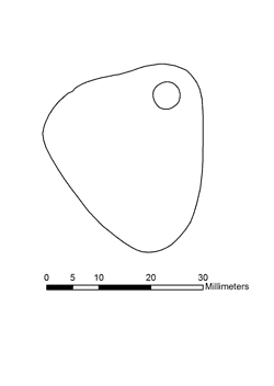